Introduction
 The city of Pathankot previously used to be a tehsil of the Gurdaspur district, Punjab but on 27th July, 2011, Pathankot was officially declared as the District of Punjab. Surrounded by the picturesque Shivalik Mountain Ranges on the south and east, and the snow-capped Himalayas in the north and the Chakki River, Pathankot is situated on the foothills of Kangra and Dalhousie. It stands at an average elevation of 332 metres, while the two main rivers Beas and Ravi passes through this district. The official language spoken here is mainly Punjabi but Dogri is also pretty common. It is known that after the liberalisation of the Indian economy, Pathankot emerged as a commercial centre of wholesalers and distributors of consumer goods and services, catering to Himachal Pradesh, Jammu and Kashmir and northwest Punjab.
History of Pathankot
 The history of Pathankot can be traced back to the ancient period of the great epic, the Mahabharata. It is believed that the city, which was named Prathisthan during that time, was under the kingdom of Audambra. The name Prathisthan meant "the firmly established place". And in the ancient book of Ain-i-Akbari, Pathankot was noted as Pargana Headquarter. The numerous antique coins suggest that the city had a significant place in the past ruled by many rulers. It is said that Pathankot is world famous for its military station known as Mammon Cantonment, which is known to be the biggest Military base in Asia.
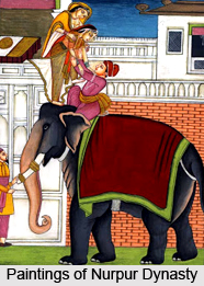
During the 17th century, Pathankot was under the administration of the Pathania Rajputs, who ruled from Nurpur in Himachal Pradesh. The Nurpur state was established by Rana Bhet, a Taur Rajput of Delhi, who was well-known as Jatpal. He established his dynasty at Pathankot and took control of the whole country in the foothills of the Himalayas. Till 1781, the city of Pathankot was ruled by Raja Sayed Khan of Nurpur state, who was one of the Muslim descendants of a Mughal Emperor. By the end of the 17th century, Jatpal shifted his capital to Nurpur. Pathankot"s history is seeped with a long line of generations relating to various religions and royal clans. Thus according to Sikh history, it is believed that, Pathankot was established by the first Sikh Guru, Guru Nanak Dev Ji. During the medieval period, when the Ghilzai tribe of Pathan in Afghanistan came into power, the Pathan tribes of Afghanistan, namely the Marwat, Khattak, Yusufzai and other Pathans moved to India. They settled in places like Pathankot and Hoshiarpur. According to a famous historian named Sir A Cunnigham, the name of Pathankot originated from the word "Pathan". And thus, came forth the name Pathankot. It is also known that between the 17 to 18th century this region was ruled by Rajput rulers.
After the independence of India in 1947, Pathankot developed as an important township in many aspects. The city"s strategic location has prompted the establishment of an army and air force station. And after the partition of India, a huge number of people migrated from West Punjab also known as present day Pakistan, and settled in and around Pathankot. Most of these people started their own trade and contributed to the growth of the city and its surrounding area.
Visiting Information on Pathankot
The domestic civil airport, Pathankot Airport IXP is just 3 km from the main city of Pathankot and is 7 km from the city"s railway station located on the Pathankot to Majra Road under Pathankot Air Force Station. The Pathankot Airport is well connected to major cities like Delhi. The nearest International Airport from Pathankot is Sri Guru Ram Dass Ji International Airport at Amritsar, which is about 119 km from the city.
Geography of Pathankot
 Experts say that Pathankot has drawn the attention of a multitude of tourists and visitors. As far as geography of Pathankot is concerned, it is of immense significance.
It is a conflux of 3 states of North India like Punjab, Himachal Pradesh and Jammu Kashmir. Branches of Indian Army and Indian Air Force also have been established here. Pathankot also has the principal military base in Asian continent.
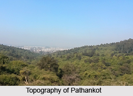
Due to this strategic location and importance Pathankot is popularly called cock neck city. Multiple mountains and mighty rivers form its boundaries, which enrich the geography of Pathankot. It lies at the foothills of Dalhousie and Kangra, and also the river Chakki flows in the vicinity. It is a best stop over before one go for mountains like Dalhousie, Jammu and Kashmir, Chamba, and Kangra. Pathankot rises approximately at 32.28° N 75.65° E. It has an average height of 332 meters or 1089 feet.
No discussion on geography of Pathankot takes a concrete shape without the knowledge of its demographical details. In this regard the census report of India that has been published in the year 2001 deserves special mentioning. According to this report, the total population of Pathankot has shown a measurement of 159,559. Out of it, male populace constitutes 55 % of the population. In comparison, female populace is less thus constituting 45 % only. Information about literacy rate too can be known. Pathankot has shown an average literacy rate of 77 %, which is even higher than that of the entire nation, which constitutes 59.5 %. Specifications about male and female literacy rates too can be inferred. Male literacy rate is 80 %. However the rate of female literacy also is no less insignificant. Thus it constitutes 73 % . In Pathankot, children who are below six years of age constitute 11 % of the total population.
Out of the total population Hindus forms the majority constituting 80 % of the total population . The remaining 15% comprises of Sikh community . Christians constitute 5 %. In Pathankot, languages like Punjabi, Hindi, Dogri, Pashto are widely spoken by the people.
Climatic condition helps any one to know about the geography of Pathankot in much better way. The people of Pathankot witness extreme climatic situation. Summers are hot and humid. Winters are freezing where mercury level drops down to a very low degree. Ample rainfall makes the region fertile and thriving.
Rivers constitute an important aspect of geography of Pathankot. Rivers like Ravi and Chakki flow this region of Pathankot. Badhahi canal, better known as Pathanki, irrigates Pathankot.
Climate of Pathankot
 The average temperature during summer is generally between 34° C to 46° C and during the monsoon season, Pathankot receives moderate to heavy rainfall. Winters are mild but can get quite chilly with the average temperature ranging between 7° C to 15° C with occasional rainfall in between. Pathankot experienced snowfall in 2012 after almost 55 years. Relative humidity is generally high in the mornings, exceeding 70% except during the summer season when it is less than 50%. The humidity is comparatively less in the afternoons. The driest part of the year is the summer season when the relative humidity in the afternoon is about 25% or less.
Demographics of Pathankot
As per the reports of Census India 2011, the total population of the Pathankot district is 1, 48,937 out of which the males and females are 78,117 and 70,820 respectively. The literacy rate was 88.71% and the majority religion here in Pathankot is Hinduism. The city is known to be the 9th most populous city in the state of Punjab.
Culture of Pathankot
 Historians claim that the culture of Pathankot represents the ethnicity, tradition and richness in its true sense. This is evident from its plethora of cultural traits like music, dance, and culinary delights and many more. Fairs and festivals are part and parcel of the culture of Pathankot. Those are the days when the localites get engrossed with the festivity and get respite from the mundane sorrows and hassles.
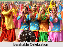
Pathankot is integrated to the Gurdaspur district of Punjab state. It is needless to say that culture of Pathankot too is highly influenced by its cultural heritage. Baisakhi fair is the much-acclaimed fair, which is celebrated in much enthusiasm and vigor. Usually this fair is held for 3 consecutive days, which last from 1st to 3rd Baisakh. It falls under 13 to 15 April. Since a prolonged period of time, a huge Shivratri fair is celebrated annually in the premises of Mahakaleshwar temple on the day of `Shivratri`. Myriads of pilgrims and tourists from various parts of the state throng the place and thus fete Shivratri.
Culture of Pathankot is embellished due to the culinary habits of the people concerned. Due to easy available in the state it is obvious that items like milk, honey, curd are widely savored by all of varied ages starting from five to fifty. The people usually cook dishes adding lots of spices and ghee. Dishes are served with butter and cream as well. For Punjabi foodies, meat, chicken are inevitable.
Dance and Music entertain the lives of people, which enrich the culture of Pathankot in its true sense. For every affair both of joy as well as sadness people love to sing songs. Individual songs are composed for every function like that of marriage, childbirth, death etc. In religious festivals songs form an integral part. Like music, exclusive dance forms are associated with the festivals attuned to their festive mood and vivacity. Usually the dances are performed with lots of vigor and energy in accompaniment of instruments like drums, etc
To know the culture of Pathankot it is a must to know the way the Pathankot people dress up. Following the trend a Punjabi man usually wear kurta, which are cut straight and long and also loose shirt teamed up with pyjamas and loosely fitted salwar, and also a `loongi or tehmat`. To bit the chilly winter days, people wear colorful and bright woolens. They are usually hand woven by females. The typical dresses of women include `salwar` with `kameez` as a top. Kameez is a dress that is loosely fitted similar to a `kurta`. Chunni or duppatta is a rectangular scarf near about 2.5 meters. Although a woman wear sweaters at times of winter she also takes immense pride in displaying her wide collection of woolen shawls.
Tribal communities and their lifestyle too form a part of the culture of Pathankot. The findings of historians have revealed that the ancient most tribes of Himachal region, namely Audumbras reside in the low hilly areas between places like Pathankot and Jwalamukhi.
Education in Pathankot
 To meet the increasing demands of the people, a handful of institutes have developed in the core of Pathankot. All these schools and colleges suffice the requirements of education in Pathankot. Not only that the private educational institutes that have built here facilitate other neighboring states like Himachal Pardesh and Jammu and Kashmir. A huge number of pupils enroll their names in the schools and colleges of Pathankot. Especially they came from the rural areas where educational opportunities are scant. SRPAAB College, SD College, RRMK Arya Mahila Mahavidyalaya, Ptk etc are worth mentioning.
Few colleges are an integral part of education in Pathankot. They offer B-Ed courses. Sri Sai College of Education is one such college which was formed at Badhani( Pathankot). It has got affiliation of Guru Nanak Dev University, Amritsar. Other B-Ed colleges include Army Institute of Higher Education, SMDRSD College of Education, Aman Bhalla College of Education. Proposals are made for starting few more collages in Pathankot.
Schools also are incorporated in the whole system of education in Pathankot. Shri Guru Harikrishan public school, St. Joseph`s Convent School, Kendra Videyalaya 1,2 3 & 4 , St. Thomas Senior Sec School, MCM DAV Public School and Air Force School.
Important Places of Pathankot
 Known to be the meeting point of three northern states, namely Punjab, Jammu and Kashmir, and Himachal Pradesh, the city of Pathankot is surrounded by the picturesque Shivalik Mountain Ranges on the south and east, and the snow-capped Himalayas in the north and the Chakki River. Situated on the foothills of the Kangra and Dalhousie, the district of Pathankot shares international border with Pakistan on its west. Due to its scenic location and a rich cultural heritage, Pathankot has many places of interest which are major tourist attractions. Listed below are some of the important places of Pathankot.
Mukteshwar Temple: Almost over 5,500 years old and located on the banks of the Ravi River, the cave temples of Mukteshwar are situated atop a hill and are dedicated to the Hindu deity, Lord Shiva. Also known as Mukesaran Mandir, the temple contains a marble Shiva Lingam and a copper yoni. The idols of various Hindu deities Lord Brahma, Lord Vishnu, Lord Hanuman, Goddess Parvati and Lord Ganesha surround the Lingam. According to the Hindu mythology, Mahabharata, it is said that the caves were used by the Pandavas as a refuge during their final year in exile.
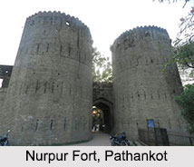
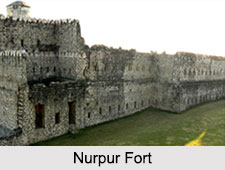
 Nurpur Fort: Built in the 10th century by the Pathania Rajputs, the fortress of Nurpur was formerly known as the Dhameri Fort. Located about 25 km from Pathankot, the Nurpur Fort is quite famous in North India. The fort was destroyed by the British and then by an earthquake in 1905. The Nurpur Fort houses a temple called the Brij Raj Swami Temple, which was built in the 16th century and is known to be one of the only places where both the idols of Lord Krishna and Meerabai are worshipped. This temple attracts a number of tourists from all across the nation.
Ranjit Sagar Dam: Constructed on the Ravi River on the border of the two states of Jammu & Kashmir and Punjab, the Ranjit Sagar Dam is known to be the highest gravity dam in Asia. Also known as the Thien Dam, it is part of a hydroelectric project, which is used for both irrigation and power generation purposes. With 600 megawatt capacity, the Thien Dam is one of the highest earth fill dams in India and has the largest diameter penstock pipes in the country. The lush green surroundings of the area make it a popular place for picnics.
Shahpur Kandi Fort: Located on the foothills of the Himalayas, the Shahpur Kandi Fort is situated on the banks of the Ravi River and is known to be built in 1505 AD by a Rajput chief named Jaspal Singh Pathania. It is said that the fort was named after the great Mughal Emperor Shah Jahan. The fort was strategically located to have control over the Kangra and Nurpur region. Presently, the fort is in complete ruins but a part of it still functions as a resting house, where the tourists come to stay and look at the ancient temples and the amazing view that the place has to offer.
Kathgarh Temple: Located at the confluence of the Beas and Chonch River, the Kathgarh Temple is dedicated to Lord Shiva and Goddess Parvati and is characterized by an ancient lingam of mystical origins. The temple is a marvelous example of Roman architectural style in the region and serves as a resting spot for people before moving up the mountainous trail of Himachal Pradesh and Jammu & Kashmir. Also known as the Pracheen Shiva Mandir, the Kathgarh Temple is one of the more famous temples in the area.
Other than these, there are other places around Pathankot which also serves as major tourist attractions like the scenic locales of Dalhousie and Khajjar, which is described as the Indian Switzerland due its picturesque locality and ample activities like zorbing ball, paragliding, and horseback riding to attract tourists. Religious places like Jwala Ji and the major pilgrimage centre and Shakti Peetha of Chintpurni are also visited by people. Places like Dharamshala, Amritsar, Palampur, Chamba, Jammu, Mukerian, Hoshiarpur, Kangra and Jalandhar are all near or over a 100 km from the city of Pathankot and are known to have a myriad list of tourist attractions.
Visiting Information on Pathankot
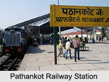
The domestic civil airport, Pathankot Airport IXP is just 3 km from the main city of Pathankot and is 7 km from the Pathankot Railway Station located on the Pathankot to Majra Road under Pathankot Air Force Station. The Pathankot Airport is well connected to major cities like Delhi. The nearest International Airport from Pathankot is Sri Guru Ram Dass Ji International Airport at Amritsar, which is about 119 kms from the city.
Transportation of Pathankot
Good transportation of Pathankot enables the people to remain connected with other places of Indian continent. From Pathankot direct train service was available to various cities like Jammu and also the capital city of Delhi. Many other cities also remain connected with other places of the country as well. From Pathankot, Chandigarh and New Delhi are situated at distances like 269 kms and 513 Kms respectively. Delhi, Shimla, Chandigarh, Jammu, Dharamshala, Dalhousie and Amritsar are significant places that stay connected with Pathankot. Pooja Express from Jammu-Jaipur, Jammu Tawi-Mumbai Express are significant.
Apart from railways, one also can access places via wide network of buses. Bus service is held a key role for creating transportation in Pathankot quite well. These include Punjab, Himachal, Delhi, Haryana, Pepsu, Chandigarh, Jammu and Kashmir.
Visiting Information on Pathankot
The domestic civil airport, Pathankot Airport IXP is just 3 km from the main city of Pathankot and is 7 km from the Pathankot Railway Station located on the Pathankot to Majra Road under Pathankot Air Force Station. The Pathankot Airport is well connected to major cities like Delhi. The nearest International Airport from Pathankot is Sri Guru Ram Dass Ji International Airport at Amritsar, which is about 119 kms from the city.


