Home > Indian History > Geography of India > Chhiplakot Peak
Chhiplakot Peak
Chhiplakot is a Himalayan peak located in Uttarakhand at an altitude of 3290 metres.

Share this Article:

Chhiplakot Peak, Pithoragarh District, Uttarakhand
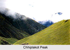
Chhiplakot is a high peak in the Himalayas located in the Uttarakhand state of India. Chipplakot is also referred to as `Najurkot`. The area near the peak is full of alpine flora and vegetation. Trekking, skiing and a tri-annual fair are the other attractions of this peak. Every year, it draws people from various parts of the world.

Location of Chhiplakot Peak
The peak is located in the Pithoragarh district of Uttarakhand. The peak is situated at an altitude of 3290 metres above mean sea level.

Attractions of Chhiplakot Peak
Chipplakot is well known for its lush green alpine meadow called Bugyal. The peak offers exciting trekking opportunities and is a paradise for nature lovers. The slopes of Chipplakot are ideal for skiing. It also has temples around it that are worth visiting. There is a cave at Chhiplakot where a winter fair is organized after every three years.

Connectivity of Chhiplakot Peak
It is well connected via rail, air and road. The city of Uttarakhand comprises of major railway stations like Dehradun, Kathgodam, Kotdwara, Pantnagar and Roorkee. The closest airport is Jolly Grant Airport near Dehradun. Uttarakhand is also well connected to almost all the important places in the state via bus services.

This article is a stub. You can enrich by adding more information to it. Send your Write Up to content@indianetzone.com


Share this Article:

Related Articles

More Articles in Geography of India


Geography of Uttar Pradesh
The fourth largest State in India UP is located in the Northern part of India whose area is 2,36,286 sq Kms.
Geography of Maharashtra
Covering an area of 308,000 sq. km, Maharashtra, the third largest state in India.
Geography of Kerala
Geography of Kerala includes plains, hills, valleys and coasts. With the Arabian Sea in the west, the Western Ghats in the east and networked by several rivers, Kerala enjoys diverse geographical features.
Geography of West Bengal
The geography of West Bengal is unique with high peaks of the Himalayan range in the north, the Bay of Bengal in the south and the remaining region is covered with both plains and plateaus.
Geography of Jharkhand
Geography of Jharkhand is comprised of the rich mineral resources and the highly agricultural prospect in this state.
Geography of Sikkim
Geography of Sikkim is characterised by a vast array of magnificent hillock that extends from one corner of the state to the other.
Geography of Meghalaya
The suitable climate, highland plateaus, rivers and the flora and fauna together forms the geography of Meghalaya.
Geography of Mizoram
Mizoram is surrounded by hills, valleys, rivers, waterfalls and lakes. The hills range from 1000 meters to 2000 meters. Rivers, lakes and waterfalls also play major role in forming the land of Mizoram.
Geography of Jammu & Kashmir
Jammu and Kashmir is encompassed by valleys. Some of the dominant valleys of the state are Kashmir Valley, Tawi Valley, Chenab Valley, Poonch Valley, Sind Valley and Lidder Valley etc. Jhelum River is the only major Himalayan River which flows through the Kashmir valley. Indus, Tawi, Ravi and Chenab Rivers are the major ones flowing through the region.
Geography of Daman and Diu
Daman and Diu is situated on the west coast of India and are the smallest union territories of India.
Geography of Goa
Geography of Goa occupies a prime location along the Konkan coastal belt on the western coast of India. The state is bordered by Maharashtra in the north and Karnataka in the south. The Western Ghats in the east contribute to the flora and fauna of Goa.
Geography of Arunachal Pradesh
Geography of Arunachal Pradesh reveals that it is a hilly tract nestled in the foot of Himalayas.
Geography of Kutch
Geography of Kutch District is covering an area of 45,612 km. Kutch District is the largest district in the state of Gujarat.
Geography of Ladakh
Geography of Ladakh mainly comprises the huge Karakoram Range with long stretch of cold desert which mark the region separately from the rest of the states of Indian subcontinent. Surrounded with the mountain ranges from all corners this small region separates Indian subcontinent from rest of the Asian continent.
Geography of Rajasthan
Geography of Rajasthan defines the dry topography with arid climate of the western mountain region.
Geography of Tamil Nadu
The Indian state of Tamil Nadu is located in the Northern hemisphere in the hot zone.