 Girnar mountain range is one of the exquisite mountain ranges of Gujarat located at an average elevation of 3660 feet above mean sea level. It is located in the outskirts of the Junagadh district in the western state of Gujarat and is the highest peak in the state. Girnar mountain ranges are considered sacred and it`s an important pilgrimage site for both Hindus and Jains, who gather here during the Girnar Parikrama festival.
Attractions of Girnar Mountain Range
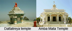
This mountain range has five peaks, which consists of beautifully carved stone temples that are the popular pilgrimage destination among the Jain and Hindu community in the state. The five peaks come in the following order: the Neminath Temple followed by the Amba Mata Temple in the first peak, the second peak is known as the Guru Goraknath peak, and the third peak is known as the Oghad peak. Then is the peak of the Dattatreya temple followed by the peak of Kalika temple. It is believed in Hinduism that if one climbs Girnar hills barefooted, one earns a place in heaven.
The Gir reserved forest is located near the Girnar Hills, which is the home to the Asiatic lions in India. It is located in the east of Junagadh at a distance of 5 km. There is a rock at the foot of the hill, bearing an inscription of Ashoka (2nd century BC). It also has two other inscriptions, which dates back to 150 and 455 AD. For its much acclaimed Kathiawadi culture Girnar is indeed well known.
 The Girnar mountain range has some of the well carved Jain temples. The most popular temples located in this mountain range are temples of `Jatashanker Mahadev` and `Gaumukhi Ganga`. The famous places like `Sheshavan`, `Bharanvan` and `Hanumandhara`, nearer to the temple of `Gaumukhi Ganga` are located near the `Gaumukhi Ganga`. These temples are mainly constructed under the supervision of Gupta dynasty. These shrines add to the beauty of the mountain range which can be viewed from a distance.
Thus, with its look and lush greenery it is one of the most attractive mountain ranges of Gujarat. Located besides the Damodarji temple, this mountain range adds to scenic beauty of the place.
Connectivity of Girnar Mountain Range
Girnar mountain range is accessible by air, trains and roads and state transport are also available. The nearest airport is at Rajkot - about 100 km from Junagadh which is well connected with many major Indian cities. The nearest International airport is in Ahmedabad.


