Introduction
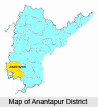 Anatapur is a place that blends history and modernity on one side and pilgrimage and forts on the other-side. Puttaparthi, the home of Sri Satya Sai Baba, believed to be the reincarnation of Shirdi Sai Baba, is located in Anantapur. The 550-year-old banyan tree that is mentioned in the Guiness Book of World Records for its enormous size is found here. Lepakshi temple is the famous tourist attraction of this district. Anantapur is known for its silk trade in the modern industry. Anantapur is the hometown of former President of the Republic of India, Shri Neelam Sanjeeva Reddy.\
Origin of name of Anantapur
It is believed that the place got its name from `Anaatasagaram`, which was a big tank in Ananatapur that means "Endless Ocean". Some assert that the city was named after the queen of Anantarasa Chilkkavodeya, the former ruler while some say that the place has been named after Anantarasa himself.
Geography of Anantapur
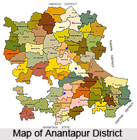 Anantpur district lies between 13`-40` and 15`-15` Northern Latitude and 76`-50` and 78`-30` Eastern Longitude. It is bounded by Bellary district and Kurnool district on the North, by the Cuddapah and Kolar districts of Karnataka on the South-East and North respectively. The district is roughly oblong in shape, the longer side running north to South with a portion of Chitradurg District of Karnataka State intruding into it from west between Kundurpi and Amarapuram Mandals.
The District may be divided into 3 Natural Divisions. They are:
1) Northern Mandal of Rayadurg, Kanekal, Beluguppa, Gooty, Guntakal, Vajrakarur, Uravakonda, Vidapanakal, Yadiki, Tadipatri, Putlur and Yellanur containing larger areas of Black Cotton soils
2) Kalyandurg, Kambadur, Settur, Brahmasamudram, Ramagiri, Kanaganapalli, C.K.Palli, Dharmavaram, Bathalapalli, Tadimarri, Mudigubba, Anantapur, Kudair, Pamidi and Peddavadugur in the centre which are mainly made up of arid, treeless, expanse of poor Red Soil.
3) High Level Land of Penukonda, Roddam, Somandepalli, Hindupur, Lepakshi, Chilamathur, Madakasira, Rolla, Gudibanda and Agali which connects with Mysore plateau at higher elevation of the rest of the district. This part has average sandy red soils of normal productivity.
Running from the North of Gooty town up to the extreme Southern corner of Tadipatri and Yadiki Mandals for a length of about 35 kms are the Muchukota Hills. Another line of hills, the Nagasamudram hills starts from West of Gooty Mandal and runs for a length of 80 kms. The Mallappakonda Range begins at Dharmavaram and runs into Karnataka State. The Penukonda Range which starts in the South of Dharmavaram through Penukonda and Hindupur proceeds to Karnataka State. In Madakasira, the hills divide Rolla and Agali Mandals into Southern and Northern portions. There are numerous isolated Peaks and Rocky Clusters which are devoid of any vegetation. The forests in the Anantpur district are thin and scanty.
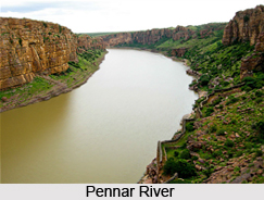
Among the various rivers running in the district the most important is the Pennar River. It has its origins in the Nandi Hills of the state of Karnataka. It enters the Anantpur district from the extreme South of Hindupur Mandal and flows through Parigi, Roddam, Ramagiri, Kambadur, Kalyandurg, Beluguppa, Uravakonda, Vajrakarur, Pamidi, Peddavadugur, Peddapappur and Tadipatri Mandals and finally enters Cuddapah District. The Jayamangala River, which has its origins in Karnataka, enters the district through the Parigi Mandal and joins Pennar River at Sangameswarampalli of Parigi Mandal. Another important river in the district is the Chitravathi, which also originates in Karnataka State. This river enters the District near Kodikonda village of Chilamathur Mandal and flows North over the rocky and hilly upland before falling into the Pennar River at Gandikota in Cuddapah District. The Vedavathi River flows through Gummagatta, Brahmasamudram, Beluguppa, Kanekal and D.Hirehal Mandals and enters Bellary District of Karnataka State. The Bhairavanithippa project has been constructed on this river. Apart from these streams like Kushavathi in Chilamathur Mandal, Swarnamukhi in Agali Mandal, Maddiler in Nallamada, Kadiri and Mudigubba Mandals, Pandameru in Kanaganipalli, Raptadu, Anantapur B.K.Samudram and Singanamala Mandals, Papagni in Tanakal Mandal are important water supply sources to various large and medium irrigation tanks in the district.
 The climate of Anantpur district is tolerable throughout the year, which is a result of the fairly good elevation of the district. The topography of the land is such that it has a gradual fall from the South North towards the valley of the Pennar in Peddavadugur, Peddapappur and Tadipatri Mandals. There is a gradual rise in Hindupur, Parigi, Lepakshi, Chilamathur, Agali, Rolla and Madakasira Mandals in the South to join the Karnataka Plateau where the average elevation is about 2000 feet above the mean sea level. It is about 1100 feet at Anantapur and the lowest 900 feet is at Tadipatri. The geographical position of the peninsula is such that it renders the place as the driest part of the state. As a result of this, agricultural conditions too are rather precarious. Being far from the East coast, it does not enjoy the full benefits of North East Monsoons and being cut off by the high Western Ghats mountain range, the South West Monsoon is also prevented from penetrating these parched soils. It is therefore seen that the district is often deprived of the monsoons and subjected to droughts due to bad seasons. The normal rainfall of the district is 553.0 mms, which means that it secures least rainfall when compared to Rayalaseema and other parts of Andhra Pradesh. The normal rainfall for the South West Monsoon period is 338.0 mms which forms about 61.2% of the total rainfall for the year. The rainfall for North East monsoon period is 156.0 mms only, which forms 28.3% mms of the total rainfall for the year (October to December). The other months are almost dry. March, April and May are warm months when the normal daily maximum temperature ranges between 29.1 C to 40.3 C. November, December and January are cooler months when the temperature falls about 15.7 C, Hindupur, Parigi, Lepakshi, Chilamathur, Agali, Rolla and Madakasira Mandals being at High Elevation are cooler than the rest of the Mandals in the District.
Most of the soil at Anantapur district is Red soil. Exceptions are found at Kanekal, Bommanahal, Vidapanakal, Uravakonda, Vajrakarur, Guntakal, Gooty, Pamidi, Peddavadugur, Yadiki, Tadipatri, Yellanur, Peddapappur and Putlur mandals where red and black soils occur in almost equal proportion.
Among the various mineral resources occurring in the area, the chief resources are gold, diamonds and asbestos. There are however no large sized minerals occurring in the district.
History of Anantapur
As per history, Anantapur was known as "Hande Anantapuram". The word `Hande` means chief. Anantapur and a few other places were gifted by the Vijayanagar rulers to Hanumappa Naidu of the Hande family. Anantarasa Chilkkavodeya, a Vijayanagar ruler constructed the villages of Anaantasagaram and Bukkarayasamudram.
The place came under the Qutub Shahis, the Mughals, and the Nawabs of Cuddapah. Although the Hande chiefs continued to rule as their subordinates, it was occupied by the Palergar of Bellary during the time of Ramappa. But the place was won back by his son, Siddappa. In 1757, Morari Rao Ghorpade attacked Anantapur. It is said that Siddappa bought off the enemy for Rs.50, 000.
 Anantapur then came under the possession of Hyder Ali and Tipu Sultan. It is said that Tipu hanged all the male members of the Siddappa family except Siddappa who escaped from his imprisonment at Srirangapatnam. After Tipu`s death, Anantapur was once again taken back by Siddappa. Siddappa submitted himself to Nizam because of the treaty of 1799, which took the total control of the area. Later he was pensioned off when British occupied the territory.
Culture of Anantapur
At Anantapur, there are thousands of centers, religious or secular where weekly, monthly and annual fairs are held. Every village in Anantapur has a place of worship where religious festivals are held. These places are visited by millions of devotees throughout the year. The rituals celebrated here are traditional, in accordance with the Agamas. The major festivals of Anantapur are Durgamma Festival, Sambhulingeswara Kalyanotsavam, Kotappakonda Temple Fair etc.
Demography of Anatapur
As per the 2001 census, the population of Anantapur is 3,183,781. The total literacy rate of the state is 42.18%. The sex ratio is 952females for 1000 males.
Economy of Anatapur
The major crops cultivated at Anatapur are rice, jowar, cotton, maize, arhar, chillies, sesame, sugarcane. The major mineral stone of Anatapur is limestone.
Temples of Anantapur District
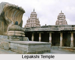
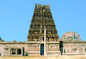 Anantpur is the largest district of Andhra Pradesh, with an economy based on partial industrialisation, but chiefly depending on agriculture. The major cities and villages of the district happen to have a place of pilgrim in almost every corner, evidence of temple architectures. Temples in Anantapur district therefore has become the logo of religiosity of the place. Some of the temple towns and their temples include- the Lepakshi Temple, Veerbhadra temple, the region of Tadipatri temples of Bugga Rama Lingeshwara Swami Temple, Aluru Ranganatha Swamy Temple, Chintala Venkata Ramana Swamy Temple. The famous Hanuman Temple, the 400-year old Lord Lakshmi Narasimha Swami Temple constructed by Raja Krishna Deva Raya. Also the region of Puttaparthi is distinguished as the hometown of Bhagwan Sri Satya Sai Baba, regarded as the holy incarnation of the almighty. Then again the temples around Rayadurg, Dharmavaram, Hemavathi, Atmakur, Bhyravanithippa, Chitrachedu, Penna Ahobilam, Kadiri and Kasapur are worth mentionable too. Almost all of them were built in the pre-historic era (with extravagant handiwork), the structural pattern resembling each other. The temples of Anantapur has also attracted tourist all over the country whilst supporting the tourism industry.
Venkatramana Temple
Location: Tadpatri near Gooty (Anantapur)
Deity: Venkataramana
This temple also belongs to the Vijayanagar period. This 6th century temple has intricate work on the walls and pillars of the Mandapams.
Doddeswara Swamy Aalayam Temples
Location: Hemavati near Madakasira, Anantapur
Deity: Lord Shiva
The village has four famous Sivalayas built and patronised by Pallavas here, where the Nolamba artists made the sculptures. Among the four Siddheswara, Virupaksheswara, Malleswara and Doddeswara temples, the last one is famous for its six-foot-high Sivalinga. The walls are covered with images sculptured that narrate stories from the great epics Mahabharata and Ramayana. This temple was constructed during the eighth century.
Bhogeswaraswamy Aalayam Temple
Location: Pamidi near Gooty-Anantapur
Deity: Lord Shiva
Lord Parasurama built this aalaya at the foot of Simhagiri hill. He installed the idols of Gauri and Shankar along with Kesavaswami. Agasthya, Rishyasringa and Simhagiri Bhat performed penance here. The Shivalinga is about five feet in high and swyambhu. As the serpent entwines the Sivalinga, it was appropriately called Bhogeswaralinga. The temple is adorned with beautiful sculptures representing Nandi, Navagrahas, and Vinayaka etc.
Legend: A cowherd observed one of his cows standing over an anthill and allowing its milk to flow down into it. He tried to break it with an axe - a voice informed him to leave it and to build an aalaya for Lord Bhogeswaraswamy. The next day he removed the anthill and found a big Sivalinga encircled by a serpent. He built an aalaya over it and another one for Goddess Parvati. He was instructed in his dream by Adisesha to build a small hamlet around, and name it Seshagrandhipuram.
 Bugga Ramalingeswara Temple
Location: Tadparti near Anantapur
Deity: Lord Shiva
There are two temples here the Bugga Ramalingeswara Temple and the Chintala Venkataramana Temple. Both are situated on the banks of river Pinakini, which becomes Uttara Vahini, and is considered as a sacred spot.
The Siva temple faces the west and is more ancient. This place was called Bhaskara Kshetras and had plenty of palm trees hence was called Tamlapalli (Tati Vanain) and was renamed as Tadpatri. The icon of the Lord is uncut and roughly formed and hence the popular tradition is that the Linga is Swayambu or self manifested.
Legend: Lord Parashurama lived and performed penance here worshipping Lord Siva. There is an underground water stream that trickles into the Garbha Griha, where the Siva Linga was consecrated.
Ramalingeswara Temple
This temple dates back to the 15th Century Vijayanagar Empire and has elements of Chalukyan, Chola and Vijayanagar art. According to legend the spot where Ramalingeswara temple stands, Lord Parashurama lived and performed penance here. The idol is uncut and roughly formed and hence the popular tradition that the linga is Swayambu.
Veerabhadra Temple (Lepakshi)
The temple is an example of Vijayanagar architecture and was built in the 16th century and is situated on a mound. A huge granite nandi bull stands outside and is carved out of single rock. The ceilings are covered in mural paintings. It is constructed on low rocky hill, which the locals call as Kurmasaila, because it resembles a tortoise.