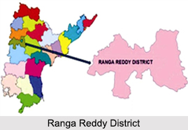
 Ranga Reddy District in Telangana is located in the central part of the Deccan plateau and is among the 23 districts of Telangana. The district has been named after the deputy chief minister of Andhra Pradesh K.V Ranga Reddy. On the 15th of August 1978 the Ranga Reddy district was formed. Ranga Reddy district can be called the rural hinterland of Hyderabad, the capital city of both Andhra Pradesh and Telangana as it feeds the region with its supplies of raw materials.
History of Ranga Reddy District
Under the rule of the Nizams of Hyderabad the district of Ranga Reddy was formed in the year 1948. In the early years, the district was known by the name Hyderabad Rural District. Later on the new district with the name Ranga Reddy was formed by carving out the twin cities of Hyderabad and Secunderabad and some urban areas of Hyderabad district was included within the realm of Ranga Reddy district.
Geography of Ranga Reddy District
Ranga Reddy District is bounded by Medak district in the north; Nalgonda district in the east, on the south of Ranga Reddy district is Mahbubnagar district and is bounded by Gulbarga district of Karnataka towards the south. The district encompasses an area of 7662.71 square kilometers. Ranga Reddy District has been divided into 37 mandals.
The physiology of the district comprises a number of plains which are crisscrossed by small and big rivers and rivulets here and there. The main rivers of the district are Musi River and Kagna River. As far as climate of the region is concerned, the maximum and the minimum temperatures are recorded as 30 degrees and 13.6 degrees respectively. The average rainfall of the region is generally 781.5 mm.
 Demography of Ranga Reddy District
According to the census of 2011, the Ranga Reddy District has a population of 24, 46,265. The density of population in the district is 468 persons per square kilometre and as far as the number of males and females are concerned. The literacy rate in the district is 76 percent according to the census of 2011 among the literate population more number of males are literate than the females.
Culture of Ranga Reddy District
Ranga Reddy District has forever been known as a meeting ground for different civilizations, cultures, languages, religions, traditions and races. This is because the district has been closely influenced by both the districts of Hyderabad and Secunderabad. The predominant culture that is witnessed by the people of the district is mostly a cosmopolitan urban culture as people from various parts of India migrate to the region for economic as well as academic purposes.
On the other hand the culture in the rural areas of Hyderabad still follows the age old traditions. They are orthodox in nature and yet at the same time modern in their outlook. Hence it can be said that Ranga Reddy district is an amalgamation of traditional and hi-Tech culture.
Education of Ranga Reddy District
The education of the Ranga Reddy District not limited to schools and colleges. Besides the basic educational institutes the district has a number of universities which caters to the higher education of the people of Ranga Reddy. Some of the well known universities of the district are Central University of Hyderabad at Gachibowli, Jawaharlal Nehru Technological University at Kukatpally, NALSAR (National Academy of Legal Studies And Research) University and A.P. Agricultural University at Rajendranagar.
Economy of Ranga Reddy District
The predominant occupation in the district of Ranga Reddy is agriculture. The main crops which are grown in the region are cotton, maize, sugar cane, ground nut, red gram, etc. Leaving aside agriculture, the other activities which are practiced by the farmers of the sub-urban areas are horticulture, vegetable cultivation and dairy farming.
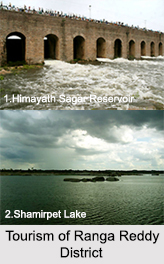
Tourism of Ranga Reddy District
As Ranga Reddy district is a perfect blend of ethnicity and modernity, both ancient and modern stalwarts of the district stand side by side. The antiquities of the district include Himayath Sagar Reservoir, Maheshwaram, Chilkur, Shamirpet Lake, Anantagiri Hills and Durgam Cheruvu.


