 Ritchie`s Archipelago, a cluster of smaller islands, lying at some 25-30 km east of Great Andaman is the main island group of the Andaman Islands. The Andamans are located in the Bay of Bengal, bordering with the Andaman Sea and are some 200 km south of the nearest Asian mainland, Cape Negrais in Myanmar.
The Ritchie`s Archipelago comprises some 4 larger islands, 7 smaller islands and several islets, extending in a roughly north-south chain, parallel to the main Great Andaman group. Baratang Island and South Andaman Island usually lie to the west across Diligent Strait; the active volcano Barren Island is almost 75 km further to the east.
The main islands in the Ritchie`s Archipelago in decreasing order of approximate size are as follows -
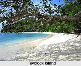
| Havelock Island- 92 km² |
Outram Island - 13 km² |
Middle Button Island - 0.4 km² |
| Henry Lawrence Island - 55 km² |
Neil Island - 12.6 km² (also Neill I.) |
North Button Island - 0.25 km² |
| John Lawrence Island - 35 km² |
Nicholson Island - 1.8 km² |
South Button Island - 0.1 km² |
| Sir William Peel Island - 23 km² (more commonly abbreviated to Peel I.) |
Inglis Island - 1.4 km² (also called East I.) |
|
| Wilson Island - 14 km² |
Sir Hugh Rose Island - 0.6 km² (often abbreviated to Hugh Rose I.) |
|
The indigenous Great Andamanese peoples initially populated the Ritchie`s Archipelago. Particularly, the tribal and linguistic grouping known as Aka-Bale lived on this island. However, as the populations of the various Andamanese indigenous peoples declined greatly in the decades following the establishment of colonial settlements by the British Raj (and later, independent India), the indigenous communities of Ritchie`s Archipelago gradually vanished. The present population of Ritchie`s Archipelago consists of immigrant Indian and a few Karen (Burmese) settlers.
Together with the rest of the Andamans, Ritchie`s Archipelago is incorporated into the Indian union territory of the Andaman and Nicobar Islands, and part of the Andaman district. It is administered by the tehsil or the local government sub-division, roughly equivalent to a country of Port Blair. The territory`s capital and administrative center also called Port Blair, is located approximately 45 km to the southwest of the archipelago, which is accessible through a 3-5 hour ferry trip. The 2001 census of India reported more than 8,200 people living on the islands of Ritchie`s Archipelago, most of these on Havelock and Neil islands.
The islands of Ritchie`s Archipelago run in a closely spaced arc, which expands about 60 km from the southern-most Hugh Rose I. to North Button I., with the strait between them and Great Andaman ranging from 30 km to less than 10 km. Most of the islands of Ritchie`s Archipelago are clustered closely together separated by only narrow, almost river-like channels. The exceptions are Hugh Ross and Neil Is to the south of Havelock, and the three small Button Islands, which are smaller outliers to the north of the group.
The interior of most of the islands of Ritchie`s Archipelago consists of undulating hills and plains, with topography not exceeding 100 m above mean sea level. Occasionally the land rises abruptly from the sea to a domed plateau, and there are a few rocky coastal cliffs; however, in the main the coastlines are relatively flat, interspersed by both rocky and sand beaches and some low-lying lagoons and estuaries on the larger islands. Coral reefs surround many of the islands, particularly on the "sea-ward" coastlines.
The Ritchie`s Archipelago is named after an 18th century British marine surveyor, John Ritchie, who spent almost two decades in the utilisation of the Council of Bengal charting and documenting the Andamans and surrounding regions. Of the archipelago, which now bears his name, Ritchie`s accounts and maps were the first reliable sources of information on the islands, which until then were very inaccurately known to Europeans. Ritchie was one who championed that the British administration in India also made further investigation and developed Andamans. During Ritchie`s time these entreaties were largely unnoticed. Perhaps aggravated and disappointed after years of thankless work under difficult circumstances, Ritchie requested to be returned for home leave, which he was in 1787.
Two years after Ritchie`s departure, an attempt was made to set up a colony in the Andamans, but this was canceled after only a few years. It was not until 1867 that a permanent European presence was established in Ritchie`s Archipelago, when the British invaded the islands and a penal colony was established at Port Blair on South Andaman Island, later known as Ritchie`s Archipelago.
Today, Ritchie`s Archipelago is not only an inhabiting island but also a tourist spot and haven for a series of water sports and fishing communities.


