 Warna River and Yerla River converge with the River Krishna in Sangli district of Maharashtra. The floods of Warna River causes damage to the region it flows through every year. The four villages namely Aitawad Khurd, Kanegaon, Koregaon and Shigaon are the worst affected ones, along with Walwa taluka and three villages; namely the Sawalwadi, Dudhgaon and Samdoli.
History of Warna River
The known highest floods were, however, of the year 1914. The three rivers had heavy floods in 1950, 1953, 1955, 1958 and 1961. In 1953 the floods of the river Warna came unpredictably and the floodwaters encircled Shigaon, Koregaon and Kanegaon villages in Walwa taluka.
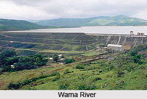
Warna Irrigation Project
Warna is a foremost irrigation project under construction across river Warna in River Krishna basin near the village Chandoli in Shirla Taluka of Sangli District of Maharashtra. The project is planned to supply irrigation in 289 villages in Sangli, Satara and Kolhapur districts of Maharashtra. The construction of the project was started in the year 1976 and the dam is completed in the year 1998.
Visiting Information of Warna River
It takes around 39 minutes to travel from Warna River to Kolhapur. Estimated driving distance between Warna River and Kolhapur is 33 kilometres. Travel time demotes to the time taken if the distance is covered by a car.
This article is a stub. You can enrich by adding more information to it. Send your Write Up to content@indianetzone.com.


