 The Noyyal River starts from the Vellingiri hills in the Western Ghats in Tamil Nadu. This sacred river attracts many devotees from almost all parts of Tamil Nadu. The river flows downward to south-eastern India and empties into the Kaveri River. The length of the river basin is 180 km and it is 25 km wide, covering a total area of 3,500 sqkm. The fertile land in the basin is around 1,800 sqkm.
The area of the Noyyal River is known for its inadequate rainfall and the development of the Noyyal River Tanks System to hold any overflow from the rains plus the water of the Northeast and Southwest monsoon season was economically important. The 173 km long tributary of the Kaveri River filled 32 tanks. These interconnecting tanks hold the water flowing from the Noyyal.
Ecosystem of Noyyal River
Coimbatore was flanked by Noyyal River and its various meandering canals, rivulets and tanks. All this was built by Chalukya Cholas kings for smooth water transportation in that area as well as adjoining areas. After making its way through a distance of about 160 km, Noyyal merges with Kaveri River near Kodumudi. It is also home to major dams like Aathupalayam Dam and Orathuppalayam Dam.
As the region developed, the system was no longer used, the number of tanks was drastically reduced, and only 11 tanks were remaining. Agriculture has radically decreased. Lacking irrigation water, lakhs of Coconut trees in the area have dried up.
History of Noyyal River
The "Noyyal" is a sacred river in Tamil history and its original name was "Kanchi Nadi", however it was later changed later to the name of the place where it drains into the Kaveri River in 1750 A.D.
 The Noyyal village is situated at the banks of Noyyal River and Kaveri River where both the rivers merge. An ancient temple of Goddess Sellandiyamman is also situated at the place of merging.
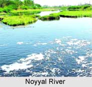
Pollution at Noyyal River
The river flows with too much natural antibiotic minerals. The river is highly polluted because of the huge concentration of cloth dyeing factories dumping their industrial wastes into the river. However since 2004, efforts have been made by local volunteers organization "Siruthuli" to conserve the water resource. After several petitions from 2003 to 2011, dyeing and bleaching units were ordered closed on the river until zero liquid discharge status was achieved.
Geography of Noyyal River
The Periyar River, the Cheyyar River and the Kanchimanadhi are the tributaries of the Noyyal River. They all have their origins in the Western Ghats. Periyar flows out of the Siruvani hills and the Kovai Kutralam, a land mark waterfalls. Cheyyar River flows through Chaadivayal and later along with the other rivers join up at Kooduthurai to become Noyyal River. After running through a distance of 160 km, Noyyal joins Kaveri River at Kodumudi in Erode District. Apart from these 3 rivers, there are 34 rivulets joining Noyyal. But most of these rivulets carry water only during the rainy season and thus are not perennial.
Dams on Noyyal River
Noyyal contains two major dam Orathuppalayam and Aathupalayam Dam constructed in the aim of irrigating about 20,000 acres of land in both Tirupur and Karur district. As of now Orathuppalayam Dam stands decommissioned and acting as effluent tank for the Tirupur textile units. The river has 23 check dams. Most are located in between Kooduthurai and Tirupur, 52 km east of Coimbatore city.


