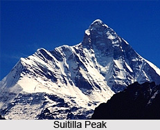
 Suitilla or Suj Tilla West is a Himalayan peak situated in the Kumaon region in the Uttarakhand state of India. Suitilla is a conical peak with a stupendous North face. It is perched at a height of 6,373 metres (20,909 feet) above mean sea level. The peak is also called as the peak of needles as it has sharp ridges like knife and steep ice flutings. Suitilla was first scaled in the year 2001 by an Indo-British joint expedition by two Britishers Graham Little and Jim Lowther. And Lt. Cdr. Satyabrata Dam led the Indian navy team.
Location of Suitilla Peak
It is located exactly in the eastern side of Uttarakhand in the Pithoragarh district. This peak is situated above the junction of the Kalabaland Sankalp and the Yankchar glaciers. The geographic coordinates of the mountain is 30°19`48 North, 80°22`48 East.
Attractions of Suitilla Peak
The peak itself is beautiful and is surrounded by other amazing peaks. The other peaks situated nearby are Rajrambha, Chaudhara and Chirangwe. Ralam Dhura pass, which connects Ralam valley to Darma valley is in the southern direction of this peak. Suj Tilla East situated at a height of 6394 metres above mean sea level is two hundred metres from Suj Tilla West. Mountaineers have not tried to climb Suj Tilla due to multiple cornices on the ridge.
Every year, Suitilla Peak attracts various explorers, adventure lovers and photographers from different corners of the world. The ideal months for climbing this peak is April, May, August, September, and October. The closest major airport is in Delhi.
This article is a stub. You can enrich by adding more information to it. Send your Write Up to content@indianetzone.com


