 The Seshachalam Hills are a part of the Eastern Ghats in Andhra Pradesh state of India. The Seshachalam hills are a group of seven hills namely, Seshadri, Neeladri, Garudadri, Anjanadri, Vrishabhadri, Narayanadri and Venkatadri. The hills are surrounded by Rayalaseema uplands in the west and northwest and the Nandyal Valley in the north. The highest peak is situated at a height of six hundred metres (2,000 feet) above mean sea level. The hills are also known as Venkatachalam. The Seshachalam hills consist of sandstone and shale along with limestone.
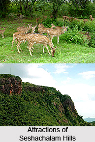
Attractions of Seshachalam Hills
Tirupati which is considered as one of the major Hindu pilgrimage towns in India is located in the hills. Tirumala Hills (the famous Natural Arch) which dates back to the period in between Middle and Upper Proterozoic Eon is also a part of Seshachalam Hills. The Srivenkateshwara National Park is also located in this mountain range. This park is popular for housing waterfalls like Talakona, Gundalakona and Gunjana. The park is enriched with varied flora and fauna. The flora mainly comprises of Red Sanders, Shorea talura, Shorea thumburggaia, Terminalia pallida, Sandalwood, Cycas beddomei, Syzygium alternifolium, Psilotum nudam. Pompadour Green Pigeon, Hawk-Cuckoo, Blue-faced Malkoha, Yellow-browed Bulbul, Indian Scimitar-Babbler and Loten`s Sunbird are some of the fauna of this park.
The forest ranges spread over an area of 4,755 square kilometres is also part of Seshachalam Hills. The forest houses many endangered animals. Owning to these reasons, Seshachalam was designated as a Biosphere Reserve in the year 2010. It became the first biosphere reserve in the entire State and sixteenth in the country. The region also is a residence for myriad natural springs and waterfalls.
Mythology of Seshachalam Hills
Hindu mythology says that the seven peaks represent the seven hoods of Lord Adisesha, the king of serpents in Hindu mythology. Tirupati or the temple of Shri Venkateswara (Lord Vishnu) is situated in the hills. According to the Puranas, Lord Vishnu was enthralled by the charm of the Seshachalam hills and started meditating here and therefore he is the lord of the seven hills.
Connectivity of Seshachalam Hills
The closest airway is the Tirupati International Airport and the nearest railway head is the Renigunta Railway junction. The suitable time to visit Seshachalam Hills is from October to March.


