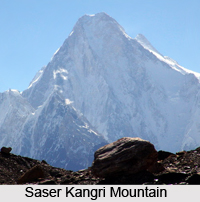
 Saser Kangri is a great mountain massif with four high peaks which rise from a glacier-clad. Also spelled as `Sasir Kangri`, it is the highest peak in Saser Muztagh, which is the easternmost sub range of the Karokoram in India. It is located within the Jammu and Kashmir state of India. Saser Kangri is the thirty- fifth highest peak in the world. The massif lies in the north-western direction of the Saser Muztagh at the top of the North Shukpa Kunchang Glacier. The Sakang and Pukpoche Glaciers are located on the western side of the group of mountains, which drain into the Nubra River.
Four Peaks of Saser Kangri Mountain
The Saser Kangri geological formation consists of four peaks, Saser Kangri I at a height of 7,672 metres (25,170 feet) above mean sea level, Saser Kangri II east at a height of 7,518 metres above mean sea level, Saser Kangri II west at a height of 7,500 meters above mean sea level, Saser Kangri III at a height of 7,495 metres (24,590 feet) above mean sea level and the Saser Kangri IV at a height of 7,416 metres (24,330 feet) above mean sea level.
Climbing History of Saser Kangri Mountain
The first successful ascent of Saser Kangri was made in the year 1973. At that time it was the highest unclimbed mountain peak in India. The expedition was made by the Indo-Tibetan Border Police. They approached the peak from the southeast, via the upper Shyok Valley and the North Shukpa Kunchang Glacier. Before this, various attempts were made to climb the peak but factors like dangerous cornices, avalanches and crevasses forced the climbers to leave the mountain.
Saser Kangri II West was first scaled in the year 1984 by an Indo-Japanese team. Saser Kangri II East was first climbed in the year 2011 by a team comprising Mark Richey, Steve Swenson and Freddie Wilkinson. Until then this peak was the world`s second highest unexplored mountain after Gangkhar Puensum. And in the year 1986, Saser Kangri III was first scaled by an Indo-Tibetan Border Police expedition team. The team included Budhiman, Neema Dorjee, Sher Singh, Tajwer Singh, Phurba Sherpa and Chhewang Somanla.


