 The Kalrayan hills form a major part of Eastern Ghats of the southern Indian state of Tamil Nadu. It lies on the western side of the Kallakurichi taluk. The region surrounding the hills was the seat of Vijaynagar Empire. The karalar tribe community dominated this place from that period onwards.
Spread over an area of 1095 square kilometres, the height of the hills varies from two thousand feet to three thousand feet above mean sea level. The hill range is divided into two portions, the northern portion is called Chinna (little) Kalrayans and the southern portion is called Periyar (big) Kalrayans. The average height of the Chinna Kalrayans is 2700 feet while the Periya Kalrayans is 4000 feet.
Attractions of Kalrayan Hills
The attractions of Kalrayan hills lure tourists from all parts of the world. The Pachaimalai, Javadi and Shevaroy and the Kalrayan hills flow between the Kaveri River basin in the north and the Palar River basin to the south. The hills are home to a number of districts of Tamil Nadu extending northeast from the Salem district. It separates the district of Salem and Villupuram districts.
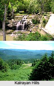
The hills have fairly smooth, with soil well-suited for plant growth. The vegetation of the hills varies according to the height with scrub jungles at a height of four hundred metres and deciduous forests at a height of eight hundred metres above mean sea level. The other tourist attractions are Megam Falls and Periyar Falls, Gomukhi Dam positioned at the Kalrayan foot hills. The hills also offer exciting opportunities for trekking.
Connectivity of Kalrayan Hills
The hills are well connected via airway, railway and road. Tiruchirapalli is the closest airport and Villupuram is the nearest railway station. From the railway station one can alight to get to Kalrayan Hills. Villupuram can be easily accessed from Pondicherry and Chennai via train. One can take a direct bus to Kallakurichi or via Villupuram. From Kallakurichi, the buses take people all over the hills but these services cannot be availed on a frequent basis. Kallakurichi is the nearest city which is located 56 km from Kalrayan hills.


