Introduction
In the Indian state of Goa, the Zuari River stands as the largest watercourse, impacting both the natural and socio-economic framework of the region. Known in older times as Aghanashini, meaning “the destroyer of sins,” the river continues to hold a place of reverence in local culture. Its tidal waters, vast basin, and strategic course make it indispensable to the Goan way of life, from trade and agriculture to tourism and biodiversity.
Origin and Length
The Zuari River originates in the Western Ghats, specifically at Hemad-Barshem, a site known for its verdant forests and perennial springs. From its source, the river travels a length of 92 kilometres, meandering across central and southern Goa before finally draining into the Arabian Sea.
While the Zuari claims the title of the longest river in
Goa, its basin is the second-largest, following that of the Mandovi. Its
connectivity with other rivers and canals, notably the Mandovi River (62
km long) and the Cumbarjua Canal (15 km), enhances its role as a vital
hydrological system in the state.

When compared with Goa’s other rivers, such as the Terekhol
(22 km), Chapora (29 km), Baga (5 km), Sal (16 km), Talpona (11 km), and
Galgibag (4 km), the Zuari’s expanse and reach are unmatched with 92 km in
length. This makes it not only the longest but also one of the most
economically and environmentally important rivers in the state.
Course of the River
The Zuari flows in a south-western direction, traversing through the talukas of Sanguem, Quepem, Ponda, Salcete, Mormugao, and Tiswadi. At Sanguem, the river merges with the Talaulim stream, and here it broadens to welcome waters from its important tributary, the Kushavati River. Other tributaries feeding into it include the Guleli and Uguem rivers, which together enrich its flow and sustain the fertile plains along its banks.
From Curchorem
to Madkai, a 28-kilometre stretch of the Zuari falls within the salinity zone,
influenced heavily by tides. Ultimately, the river empties into the Arabian Sea
near Mormugao Harbour,
one of the most prominent natural harbours on India’s west coast. The bustling
port city of Vasco
da Gama sits at its mouth, symbolizing the enduring relationship
between the river and Goa’s maritime trade.
Historical Importance of Zuari River
The Zuari River has played a key role in Goa’s history. From facilitating overseas trade during ancient period to being a hub of shipping during colonial era, the river has been instrumental in the development of trade and culture of Goa.
Ancient Trade
In pre-colonial times, the river functioned as a hub for
trade and commerce. It facilitated the exchange of goods between inland
settlements and coastal traders, helping Goa integrate into broader economic
networks.
Portuguese Colonial Era
With the arrival of the Portuguese
in the early 16th century, the river’s strategic value intensified. It became a
vital conduit for transporting spices, agricultural produce, and supplies to
and from Old Goa, then the capital of Portuguese India. The estuary’s proximity
to natural harbours ensured that the Zuari played a decisive role in sustaining
colonial power.
Thus, from ancient trade routes to colonial shipping, the
Zuari has been a constant witness to Goa’s evolving history.
Zuari Basin and Sub-Basins
The Zuari River basin extends over approximately 975 square
kilometres, accounting for nearly 27 percent of Goa’s geographical area.
Forests cover more than 31 percent of this basin, ensuring ecological diversity
and climatic regulation. Within the basin lies the Netravali Wildlife
Sanctuary, a protected area rich in flora and fauna.

Two significant sub-basins are formed by the Kushavati and Guleli-Sanguem rivers, both flowing in a north-westerly direction. The river basin is characterized by an average runoff of 2247.4 million cubic metres (MCM), which plays a crucial role in replenishing groundwater and sustaining agricultural activities.
The Cumbarjua Canal, linking the Zuari and Mandovi rivers,
has historically been a vital passage for ships navigating to the iron ore mining
areas of Goa’s hinterland. Together, the Zuari and Mandovi drain almost 69
percent of Goa’s geographical area, justifying their reputation as the state’s
“lifelines.”
Estuarine System and Ecology
The confluence of the Zuari and Mandovi near Cabo Aguada forms an extensive estuarine system, one of the largest on the west coast of India. This system is rich in biodiversity, characterized by tidal influences, brackish waters, and thriving mangrove ecosystems.
The mangrove
forests along the banks are crucial not only for stabilizing the
shoreline but also for supporting a variety of species. They act as nurseries
for fish, breeding grounds for crustaceans, and roosting sites for migratory
birds. The swampy areas adjoining the Zuari are home to crocodiles, a sight
that has become an attraction for tourists embarking on river cruises along the
Cumbarjua Canal. The calm backwaters, combined with lush greenery, make the
Zuari a favourite destination for nature lovers and adventure seekers alike.
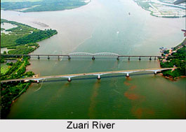
The Zuari Bridge
A landmark structure associated with the river is the Zuari
Bridge, which connects North and South Goa.
Built over the broad expanse of the river, it is the busiest bridge in the
state, serving as a critical link on National Highway 66.

In recent years, a new eight-lane cable-stayed Zuari Bridge has been developed by the Union Ministry of Road Transport and Highways. Designed to ease congestion and provide modern infrastructure, the bridge is also expected to emerge as a new icon of Goa.
Alongside it lies the Konkan Railway Bridge, spanning 1,319
metres, facilitating railway connectivity across the river. Together, these
bridges underscore the Zuari’s role as both a physical and symbolic connector
of Goa.
Economy and Livelihoods Along Zuari River Bank
Even today, the Zuari is an economic artery for Goa. Whether its fishing or agriculture, Zuari river has been a major contributor to the growth of economy of Goa.
Fisheries and Agriculture
The river sustains numerous fishing communities. Its
brackish waters and estuarine habitats provide a rich catch, forming the
livelihood base for many families. Similarly, the fertile plains nourished by
its waters support agriculture, with rice paddies, coconut groves, and seasonal
crops flourishing along its banks.
Mining and Navigation
The Zuari has also been crucial in transporting ore. The
Cumbarjua Canal allows ore-laden ships to reach the coast from mining regions
inland. While this contributes to Goa’s economy, it has also brought
environmental concerns.
Tourism along the River
In modern times, the Zuari has acquired prominence as a
tourism destination. River cruises, crocodile-spotting expeditions, and
mangrove trails attract thousands of visitors annually, adding another
dimension to the local economy.
Pollution and Environmental Concerns
While the Zuari is vital to Goa, it faces significant environmental challenges. Government has recently analyzed the water quality of the river and measures has been taken to control pollution on Zuari river and restore its water quality.
Monitoring and Reports
The Goa State Pollution Control Board (GSPCB) monitors the
river’s water quality at Panchawadi, Borim Bridge, and Marcaim Jetty. These
efforts, carried out under the National Water Quality Monitoring Programme,
have revealed worrying trends.
The stretch between Curchorem and Madkai, about 28 km long, has been classified under Priority V pollution category, with biochemical oxygen demand (BOD) levels ranging from 3.2 to 5.1 mg/litre. Fecal coliform levels also exceed the permissible limits for bathing and recreational use, indicating untreated sewage discharge as a primary pollutant.
Mining Impacts
Research by the National Institute of Oceanography (NIO)
highlights the impact of mining activities. Iron ore dumps along the banks
leach iron, manganese, cobalt, and other trace elements into the waters.
Spillage from ore transportation has further aggravated the issue. The
resulting turbidity reduces primary productivity, disrupts fish populations,
and accelerates siltation in river channels.
Conservation Efforts on Zuari River
Conservation of the Zuari River has become imperative owing to its immense ecological and economic significance. Several measures are being undertaken to safeguard this vital waterway. Strengthening sewage treatment infrastructure is a key priority to curb the discharge of untreated domestic waste into the river. At the same time, regulatory mechanisms are being enforced to monitor mining activities and prevent spillage of minerals into the waterways. Protection of mangrove ecosystems, which act as natural buffers and biodiversity hotspots, is also receiving attention through community participation and legislative safeguards. Additionally, eco-tourism initiatives are being encouraged as they not only promote awareness and conservation but also provide sustainable livelihood opportunities for local communities.
The Zuari River is more than a geographical entity, it is a symbol of Goa’s natural wealth, cultural heritage, and economic vitality. From sustaining ancient trade and colonial power to feeding fisheries, agriculture, and tourism today, its influence is profound. However, this lifeline is under increasing stress from pollution, mining, and unplanned development.
Safeguarding the Zuari is not just about protecting a river, it is about preserving the identity and future of Goa itself. Sustainable management, robust conservation policies, and active participation from local communities are essential if the river is to continue nourishing the land and people of Goa.


