 With a length of two hundred and twenty four kilometers, the Periyar River is the second longest river in Kerala after Bharathapuzha. It is one of the few perennial rivers in Kerela and is beneficial for the purpose of irrigation, drainage and navigation.
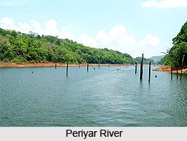
The Periyar rises in the Western Ghats of Tamil Nadu and then flows in the north direction to the Periyar National Park into the Periyar Lake, which is a man made reservoir created in 1895. From the lake, the river flows in the northwest direction and enters the Neeleswaram village. In its course it also meets the Veembanad Lake and ultimately ends up in the Arabian Sea. The Chalakkudy River meets the Periyar at Elanthikara, which is in the east of Kodungalloor at a distance of ten kilometers.
The major tributaries of Periyar are the Muthirapuzha River, Mullayar River, Cheruthoni River, Perinjankutti River and the Edamala River.
The Periyar River is a major source of drinking water for five drought prone districts of Tamil Nadu, which includes Theni, Madurai and Ramanathapuram. It is the most important river in Ernakulam district and flows through all the taluks of the district. Infact, the river plays a significant role in the all round development of the district. The Periyar River plays a major role in generating hydro electricity. The largest hydro electricity project is the Idukki Hydro-electric Project, which generates a significant portion of the electricity for the state. Other dams constructed across the river are Neriyamangalam, Pallivasal, Panniyar, Kundalam, Chenkulam, and Mullaperiyar.
There are a number of important places located on the banks of this river. The birthplace of Sankaracharya, the greatest Advaita philosopher is at Kalady, which is situated on the bank of the Periyar. Other major places of attraction on the bank of the Periyar are Malayattoor and Aluva, which are pilgrimage destinations for Christians and Hindus respectively. The Thattekadu Bird Sanctuary is situated on the banks of this river. Beside the Mullaperiyar Dam there is a well-known wildlife sanctuary and tourist place, Thekkady.


