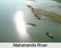
 With a length of 360 km, out of which the maximum part (324km) is in India and 36 km in Bangladesh, the Mahananda River flows between borders. It is one of the prime tributaries of the Ganga River in the eastern part of India.
Origin of Mahananda River
The mighty Mahananda River consists of two different streams; one arises from the Himalayan mountain ranges in Nepal and flows through the Indian state of Bihar. The river here is locally known by the name of Fulahar. The other stream originates from the extreme north of West Bengal from the Paglajhora Falls on the Mahaldiram hills of Darjeeling at an elevation of 2100 metres. It flows through the Mahananda Wildlife Sanctuary and descends to the plains near Siliguri and touches the Jalpaiguri district. The river then flows southwards and enters West Bengal flowing past English Bazaar, also known as Malda and then continues south-eastward into Bangladesh to join the Ganges River at Godagiri in Nawabganj district after a 360 km course.
Tributaries of the Mahananda River
The main tributaries of the Mahananda are Balason, Mechi, Kankai and Kalindri Rivers. The Balason river originates in the hills of Senchal and flows into the plains of North Bengal. Gravels and sands of the river are one of the best for the construction of houses. The Mechi River is also a trans-boundary river that flows through Nepal and India. The Kankai River is a rain-fed perennial river of eastern Nepal, the upper part of the basin consists of granitic gneiss and the lower part consists of quaternary rocks. It also has a well developed irrigation system. At the east of the confluence of the Kalindri and the Mahananda lies the Old Malda town.
The other three tributaries of the Mahananda are located in Siliguri, they are called the Trinai, Ranochondi and the pair of Chokor and Dauk taken as a single tributary.
The Mahananda river is mainly fed by the monsoons and sometimes causes floods. The river has a low water level during the summers or winters. Siliguri and Malda in the state of West Bengal in India are situated on the bank of this river.
Mahananda River
Mahananda River is a trans-boundary river that flows through the Indian states of West Bengal, Bihar and Bangladesh.


