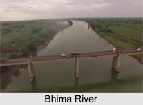
 Bhima River is one of the major confluents of the Krishna River. The river rises from the Bhimashankar hills near Karjat on the western side of the Western Ghats at an altitude of about 945 m above the sea level. It is known as Sahyadri in the state of Maharashtra. The Bhima River flows in the southeast direction for 861 km covering the states of Maharashtra, Karnataka and Telangana.
Course of Bhima River
The Bhima River originates near Bhimashankar Temple in the Bhimashankar hills in Ambegaon Taluka on the western side of the Western Ghats in Pune District of Maharashtra. In the course of the journey it meets many small rivers. The Bhima River flows through the Bhimashankar Wildlife Sanctuary where it enters the Khed Taluka and is soon joined by its tributary, the Aria River from the west which flows into the Chas Kaman Reservoir. After leaving Khed Taluka, the Bhima River forms the boundary between Haveli Taluka on the south and Shirur Taluka on the north. The Bhima River merges into the Krishna River along the border between Karnataka and Telangana about 24 km north of Raichur.
 Tributaries of Bhima River
The major tributaries of the Bhima River around Pune are Kundali River, Ghod River, Bhama River, Indrayani River, Mula River, Mutha River and Pawana River. The Indrayani, Mula, Mutha and Pawana flow through Pune and Pimpri Chinchwad city.
The major tributaries of the Bhima River in Solapur are Chandani, Kamini, Moshi, Bori, Sina, Man, Bhogwati and Nira. The Bhima meets the Nira River in Narsinghpur in Malshiras taluka in Solapur district. The last 298 km of its course is in Karnataka where it merges with the Krishna River near Kudlu in Raichur District.
The total basin area of the river is 48,631 sq. km out of which 75 percent lie in the state of Maharashtra. The banks of the Bhima River are densely populated and form a fertile agricultural land. The river also causes floods due to heavy rainfall it receives during the monsoon.
Dams on Bhima River
The Basin of Bhima River houses 22 dams. Chas Kaman Dam in Khed Taluka, Pune district, is the first dam built on Bhima River. Ujjani Dam, near Tembhurni, Solapur district, is the largest dam by capacity. The total water storage capacity of Bhima basin is about 300 TMC in Maharashtra.
Religious Significance of Bhima River
This river has religious significance due to the presence of myriad temples on its banks. Some of the famous temples are Siddhivinayak Temple of Ashtavinayak Ganesh, Pandharpur Vithoba Temple, Sri Dattatreya Temple, Sri Kshetra Hulakantheshwar Temple and Sri Kshetra Rasangi Balabheemasena Temple just to name a handful.


