 West Kameng district in Arunachal Pradesh accounts for around 8.86 per cent of the total area of this state. The name of the district is derived from the Kameng River, a tributary of the Brahmaputra River that flows through the district. West Kameng District is a mountainous tract in Arunachal Pradesh which covers an area of approximately 7422 sq kms. The headquarters of this district is Bomdila. as well as in 12 administrative circles. These administrative circles of the district include Dirang, Balemu, Nafra, Thrizino, Bhalukpong, Jameri, Sinchung, Rupa, Bomdila, Kalaktang, Thembang, Shergaon. Further, the four development blocks of this district are Dirang, Kalaktang, Nafra-Buragaon, and Thrizino.
History of West Kameng District
After the arrival of the British, this area was popularly known as North East Frontier Agency. However, in the year 1919, this tract was renamed as the `Balipara Frontier tract,` having its headquarters at Charduar of Assam. In 1946, the West Kameng district area was formed out of the Balipara Frontier tract, with the name of `Sela Sub-Agency` and its headquarters continued to be at `Charduar` of Assam. Further, in the year 1954, `Sela Sub-Agency` was renamed as the `Kameng Frontier Division` and its headquarters was later transferred to Bomdila.
Geography of West Kameng District
West Kameng district is positioned approximately between 91 degrees 30 minutes to 92 degrees 40 minutes East longitudes and 26 degrees 54 minutes to 28 degrees 1 minutes North latitudes. This district is surrounded by Tibet region of China in the North, Bhutan in the West, Tawang and East Kameng District of the state of Arunachal Pradesh are in the Northwest and East respectively and the Southern boundary adjoins Sonitpur District of the state of Assam. This district is predominantly mountainous and majority of this area is covered with the Himalaya Mountains. Kangte is the highest peak of this region.
Demography of West Kameng District
According to the Population Census in the year 2011, West Kameng District had a population of 87,013 of which male and female were 49,568 and 37,445 respectively. The population of West Kameng District constituted 6.29 percent of total population of Arunachal Pradesh. The Population Census in the year 2011 shows that the population density of West Kameng district is 12 people per sq. km. West Kameng district administers 7,422 square kilometers of areas. The average literacy rate of West Kameng in 2011 was 69.40 compared to 60.76 of 2001. If things are looked out at gender wise, male and female literacy were 75.66 and 60.80 respectively. The total literate in West Kameng District were 52,473 of which males and females were 33,111 and 19,362 respectively.
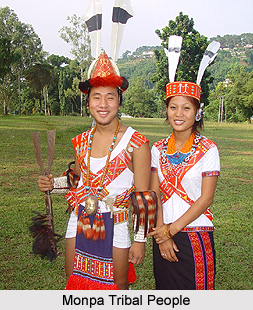
West Kameng district is the inhabitant of five major tribes and these are Monpa tribe, Miji tribe, Sherdukpen tribe, Aka tribes and Khowa tribe. Minority tribes of the district include Takpa, Lishipa, Chugpa, and Butpa. Majority of the inhabitants of West Kameng district are the followers of Buddhism, though the Aka, Khowa, and Miji tribal people have native religions and they follow a blend of Buddhism, Hinduism, and Donyi-Polo (Animism). Like the other districts of the state of Arunachal Pradesh, in this district too, people practice Jhoom or shifting cultivation. It is generally practised among the tribes living in the lower elevations where there is a moderate or subtropical climate. Tribal people of this district also practices Horticulture. They are also engaged in small scale industries like textile and handicraft factories.
West Kameng district has beautiful Apple Orchards and Buddhist temples. This magnificent district of Arunachal Pradesh also offers views of Himalayan landscapes and snow-clad ranges.


