Introduction
 Nawada District is one of the thirty-eight districts of Bihar state. The town of Nawada is the administrative headquarters of this district. It is located between historical districts of Nalanda and Gaya and falls under Magadha Commissionary. The district was part of famous Magadha Empire, Sunga Dynasty and Gupta Empire.
History of Nawada District
 History of Nawada District in Bihar includes the glorious history of Magadha Dynasty and its downfalls after the episode of sixteen Mahajanapadas. This district is also famous in various mythological sources and in Indian Epics like Ramayana and Mahabharata.
Early History of Nawada District : Nawada District located in Magadha section of division enjoys its glorious past with historical imminence. King Vahydrath established the Magadha Empire. Even king Jarasandha who`s birthplace was Tappoban had and fought with Bhima one of the Pandavas. The history bears the testimony that Bhima has visited Pakardia village, which is three miles away from the head quarters, Nawada.
The place Sitamarhi is situated in the lap of Nawada was blessed when Sita made it her above in her exile and gave birth to Lava. The village of Barat was the abode of great epic maker Valmiki. In the southern side of Rajauli sub-division of Nawada, Saptrishi had made the place for their abode.
Nawada District was held in high esteem even by Lord Buddha and Lord Mahavira. King Bimbisara was one of the most beloved disciples. The historical sermon of Lord Buddha was reveled for the first time here.
The village of Dariyapur Parvati in the Nawada District is situated six miles north of Warisaliganj. The place has ruins and relic of Kapotika Bodh Bihar. The place is adorned with the famous temple of Avalokiteshwer. King Aditaysen founded the historical monuments in the village Apsar that is visible even today. Kurkihar enjoyed its esteemed glory in the Pala dynasty. It is about three miles North East away from Warisaliganj which is a small town of Nawada. In 1857, the heroes of the time had captured Nawada and paved the way for freedom.
Modern History of Nawada District : In the modern history of Nawada History, the famous "Sarvoday Asharam" owes its name. Sarvoday Asharam is located in the district of Nawada. This Asharam was inaugurated by Desh Ratana Dr. Rajedra Prasad and nourished by Shree Jayaprakash Narayan. The Ashram is situated one and half miles away from Kawakole Police station at Village Sekhodewra. The asharam is adorned with scenic beauty and is located at the backdrop of small hills. A special feature of this place is if one stand against the highest of the hillocks and calls out, the voice is echoed back in the same very district and in human like tone. The district of Nawada has also been significant in the field of music. Great musicians of Thumri to Dhrupad genre have raised the glory of Nawada. Padma Bhushan Prasad, Siyaram Tiwari was the master of Dhrupad and Thumari belonged to Nawada.
Geography of Nawada District
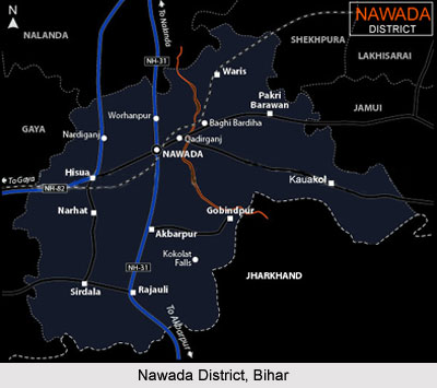
Nawada district occupies an area of 2,494 square kilometres. It is situated 24.31 east and 25.7 west latitude and 85.17 and 86.3 longitudes. The district capital is located at Nawada town. Most parts of the district are plain but certain areas have hilly characteristics. The important rivers of this district are Sakri, Khuri, Panchane, Bhusri and Tilaiya. The newly born district has fourteen blocks: (i) Nawada (ii) Hisua (iii) Govindpur (iv) Rajauli (v) Pakriwarama (vi) Warisaligunj (vii) Kawakole (vii) Narhat (ix) Roh (x) Sirdala (xi) Akwarpur (xii) Kashichak (xiii) Meskaur (xiv) Nardigunj.
Demography of Nawada District
According to the 2011 census Nawada district has a population of 2,216,653. The district has a population density of 889 inhabitants per square kilometre. Its population growth rate over the decade 2001-2011 was 22.49 %. Nawada has a sex ratio of 936 females for every 1000 males, and a literacy rate of 61.63 %.
Economy of Nawada District
The economy of Nawada District is based on agriculture. Paddy, wheat, Pulses, vegetables are the main crops of this district. The district also has Bidi factories, Sugar Mills and Handloom Silk.
The district had good sugarcane farming activities. Kadirganj, located 6 km from Nawada, has a very old and famous silk small scale industry. The industry has workers who carry out the activities of cleaning and weaving of silk. The district also maintains commercial and trading linkages with Bhagalpur that is famous for its silk business including export of silk from India. It is one of the 36 districts in Bihar currently receiving funds from the Backward Regions Grant Fund Programme (BRGF).
The district had good sugarcane farming activities. Kadirganj, located 6 km from Nawada, has a very old and famous silk small scale industry. The industry has workers who carry out the activities of cleaning and weaving of silk. The district also maintains commercial and trading linkages with Bhagalpur that is famous for its silk business including export of silk from India. It is one of the 36 districts in Bihar currently receiving funds from the Backward Regions Grant Fund Programme (BRGF).
Tourism in Nawada District
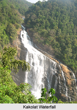 Tourism in Nawada District includes various tourist spots of nature and pilgrimage tourism. This district has numerous tourist destinations like Sarvodaya Ashram, Kakolat Waterfall, Hariya Sun Temple and many others tourist destinations.
Kakolat Waterfall : Kakolat Waterfall is a beautiful waterfall in Nawada district. The waterfall is surrounded with scenic beauty that attracts many tourists here. According to legend an ancient king was turned into a python by a rishi`s curse and lived within the falls. This is one of the best waterfalls in India.
Sekho Devra Ashram : Sarvodaya Ashram was established here in Kawakole block by Jayaprakash Narayan popularly called JP. The Ashram was inaugurated by Dr. Rajendra Prasad, India first President of India. Reportedly, he had visited Rajauli for rest and recuperation.
Hariya Sun Temple : The Hariya Sun Temple is located in Hariya village under Nardiganj block. The temple is centre of devotion for the people in this area. Water of the pond nearby this temple is treated as sacred and having curative power for the TB patients. Many gather here for Chhath puja as it has special importance.
Hanuman Temple : A Hanuman temple, dedicated to Lord Hanuman is located in the Nawada District. The foundation day of temple is celebrated on Akshay Tritiya i.e. the third day of Hindu calendar month Baisakhi.
Jarra Baba : Jarra Baba is located in Sirdalla. It is famous for fulfilling the wishes. It is supposed that no temple should be made here.


