About Kota District
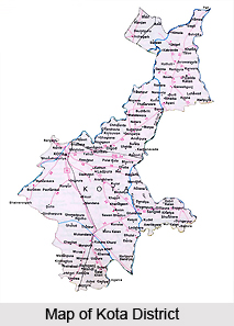 Kota District, situated in the state of Rajasthan, covers a total area of 5217 Square Kilometres. The population of the district at the last Census count stands at 827128. For the purposes of convenience in administration, the district has been divided into a number of divisions. It has a sum total of 5 subdivisions, 5 tehsils, 3 sub tehsils, 26 ILR tehsils and 204 patwar circles. The system of Panchayati Raj has been operationalised here for the purposes of convenience in administration. There are 5 Panchayat Samitis, 158 Gram Panchayats, one Nagar Nigam and 3 Nagar Palikas found existing in the district. Agricultural land in the district occupies a total area of 521324 hectares. The city of Kota situated here on the banks of the Chambal River is at an important juncture of the trade route between Gujarat and Delhi. The Chambal Valley project here is among the biggest in the state of Rajasthan.
History of Kota District
 History of Kota district city goes right back to the 12th century A.D. when the Hada Chieftain, Rao Deva, conquered the territory and founded Bundi and Hadoti. Hadoti region is the south eastern region of Rajasthan, comprising Bundi district, Baran district, Jhalawar district and Kota. The entire region has an extremely rich historical heritage dating back several centuries. Prehistoric caves, paintings, formidable forts and the mighty Chambal River hurtling from the Vindhyas are dotted in the region. Present day Kota owes its foundations to a Kotya Bhil warrior who 800 years ago built a small fortification at Akelgarh and put up a protective mud-wall around it all the way to Retwali. When Jait Singh of Bundi defeated the Bhil Chieftain Kotya in a battle, he raised the first battlement or the `Garh`(fort) over his severed head.
Later, in the early 17th century AD during the reign of the Mughal Emperor Jahangir, the ruler of Bundi, Rao Ratan Singh, gave the smaller principality of Kota to his son, Madho Singh. The independent state of Kota became a reality in 1631 when Rao Madho Singh, the second son of Rao Ratan of Bundi was made the ruler, by the Mughal Emperor Shah Jahan. The district of Kota has since been the stronghold and hallmark of Rajput gallantry and culture.
Soon Kota outgrew its parent state to become bigger in area, richer in revenue and more powerful. Maharao Bhim Singh played a pivotal role in Kota`s history, having held a `Mansab` of five thousand and being the first in his dynasty to have the title of Maharao. Kota is situated on the banks of the Chambal River and is fast emerging as an important industrial centre. It boasts of Asia`s largest fertilizer plant, precision instrument unit and atomic power station nearby. Chemicals, fertilizers, synthetic fibres, tyre cord and sophisticated instruments, industry`s mainstay, have helped in pushing this ancient city into the forefront of modernisation. Yet memories of its ancient links linger strongly.
Economy of Kota District
Kota is the industrial hub of the state of Rajasthan. There are a number of flourishing industries contributing to the economy of the district. There is a fine grained variety of limestone found here called the Kota stone which is very popular in construction. Kota stone is preferred for flooring and wall cladding, paving and facades of buildings. This industry is a major contributor to the economy of the district. There are many other industries situated here in the district. Established in the year 1985, Chambal Fertilisers and Chemicals Limited (CFCL) grew into the largest manufacturer of Urea in the private sector with an installed capacity of 1.5 million tonnes per annum. Its primary businesses are: Agri-Business (Urea fertilizer, Sugar, Farm inputs marketing such as DAP, Pesticides, Seeds, Agri retailing - Haryali Kisan Bazaars, etc.), Plastics (PVC and PVC compounds, Plastic building products - Fenesta), Chemicals (Chlor-Alkali, Chlorine based products). Other business interests comprise of Cement, Textiles and Energy Services. Instrumentation Limited (better known as IL) is a Government of India Enterprise set up in 1964 with the prime objective of attaining self reliance in the field of Control and Automation for process industry. Today IL is manufacturing and supplying state of the art control equipment on turnkey basis to various sectors and industries viz. Power, Steel, Fertilizer, Chemical, Petrochemical, Refineries, Pharmaceutical, Cement, Paper, Textile, Space, and Oil and Gas.
Tourism in Kota District
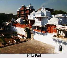
There are a number of places of tourism in the district of Kota, a silent witness to the splendour of the various dynasties that held sway here. The marvellous fort of Kota with the Durbar Hall, Brij Raj Bhawan Palace and Jag Mandir is a must visit when on a trip here. Other sites here include the Haveli of Devtaji, Chambal Gardens etc. The museums here display a remarkable collection of artistic items like Rajput miniature paintings of the Kota school, rare coins, manuscripts etc which are marvellous to behold.
Places of Interest Around Kota
 Local transportations are easily available to tour the places lying around Kota. Packaged tours are also offered to the tourists. Touring the places of interest around Kota will be a memorable experience for the travelers.
Keshoraipatan: This is located 22 kilometers northeast of Kota. It was the residence of presiding deity of Hadoti, Shri Keshav Raiji. The lord is also known as Keshoraipatan. This medieval temple has robust fortification just like any other citadel. The holy shrine is located on the bank of Chambal River. A grand fair takes place in the month of Kartik. During this fair the devotees take dip in the river, seek the Lord Krishna`s blessings and enjoy the boat race. This place is also famous for handicrafts belonging to the Hadoti kingdom. 3 kilometers away from this place lies the beautiful rock paintings adorn the bank of River Alaniya.
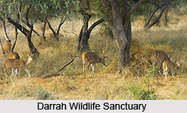
Darrah Wildlife Sanctuary: It was once upon a time the hunting reserve for the royal family of Kota. It is located at a distance of 50 kilometers from Kota. The sanctuary is situated on a sprawling 250 km. Wild animals like leopard, sloth bear, chinkara and wolf are to be found here. This place has been the muse for the Kota School of Rajasthani miniature paintings for ages. Hunting scenes from this sanctuary have been depicted in these paintings time and again.
Sorsan Grasslands: This is another natural paradise and is located at Shergarh. This place is located at a distance of 45 kilometers at the southeast of Kota. A variety of migratory birds are its major attraction. The bird lovers will have a fantastic time here as they can check out several species of birds, such as, larks, warblers, flycatchers and rosy pastors. The perfect time to visit this grassland is from October to March. Endangered species like great Indian bustard are also found here. The visitors can also catch a glimpse of bulbul, quails, partridges, mynas, shrikes, weavers and orioles.
The town of Shergarh is also important for a host of havelis, ancient ruins and temples. There is an inscription within the town that establishes its antiquity.
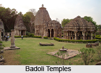
Badoli Temples: This is one of the oldest places in Rajasthan. The temples that are found here are dated between 9th to 12th centuries. Muslim invaders destroyed many of these temples but the ruins still attract. Amongst these temples the temple of Ghateshwara dedicated to Lord Shiva stands out. Here the god is depicted in various forms-- Shiva slaying the demon Chamunda, dancing Shiva and also the one with deities of Brahma and Vishnu and various other deities of the Hindu mythology. The pillars of this temple have been superbly carved with the figures celestial nymphs. There are other 2 temples that are worth checking out too. These are Trimurti Temple and Mahishasura-mardini Temple.
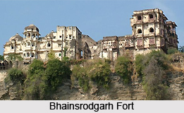
Bhainsrodgarh Fort: This fort is located around 10 kilometers on the road to Chittorgarh. Situated upon a cliff top and protected by the river Chambal on two sides, this invincible fort is occupied by descendants of the feudal family. It is open for visitors but a prior permission had to be obtained from the tourist office in Kota.
Jhalawar: It was established by Zalim Singh in 1838 at a distance of 85 kilometers from Kota. This is a well-planed city that was once an important commercial center in the 19th century. It was also a great cultural centre patronising music, theatre and art and boasted a theatre in the palace called Bhawani Natya Shala. The theatre was built emulating the western style opera houses. Cave paintings and massive forts are also important tourist destinations in Kota.
Jhalarapatan: If the travelers travel 6 kilometers further they will arrive at Jhalarapatan that literally means `city of temple bells`. Once upon a time the town had more that 100 temples but now only a few of them remain. The finest temple and the pride of the Jhalawar region is the 10th century Surya Temple. It houses one of the most idols of the Sun God. The ornately carved dome, torana archways and the columns of the temple are worth taking a close look for its fineness. There are 4 more temples located near this shrine. One of them is the 11th century Jain Temple. This temple is dedicated to Lord Shantinath.
Gagron Fort: This is a rare example of a Jal Durg (the fort protected by water). Its foundation was laid in 8th century but it took 6 centuries to complete it. The three sides of this temple are surrounded by waters of Ahu and Kali Sindh rivers. The fort has been fought over for centuries having gone through 14 major battles, to be finally captured by Emperor Akbar in 1561. It is an important part of the history of Rajasthan. The Rajputana resistance, their valor, courage and chivalry have been etched on the walls of this fort. There is also a mausoleum of a Sufi saint, Mitheshah.
 Chandkheri: The main attraction here is the Adinath Jain Temple. It is an important pilgrimage site for the followers of Digambar Jainism. The temple enshrines a huge stone statue of Adinath, the 1st Tirthankar. This place is located 35 kilometers northeast of Jhalawar. Every year in Chaitra Shukla the birth anniversary of the saint is celebrated with a lot of fervor.
Kolvi: Ancient Buddhist caves and stupas are the main local attraction at this ancient town. It is believed that these date back to the 5th century. Located near a rivulet Kyasari, the Buddhist site has two storeyed rooms (vihar), meditation chambers (chaitya) and large stupas with images of Buddha. A 15 feet high icon of a Bodhisatva is the largest statue at Kolvi. It is located 95 kilometers away from Jhalawar. All the hallmarks of a rock cut temple are present in this shrine pillars and high ceilings of the halls.
Dharm Rajeshwar: The tourists will come across a monastery at the foot of this hill. It is located on the border of Rajasthan and Madhya Pradesh. Within the monastery there is a huge figure of Buddha surrounded by his disciples.