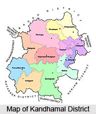
 Kandhamal District is one of the administrative districts of Orissa with its headquarters at Phulbani. Kandhamal District lies between 19 degree 34 minutes and 20 degree 50 minutes north latitude and in between 80 degrees 30 minutes and 84 degrees 48 minutes east longitude. It is bounded by Boudh district in the north, by Rayagada district in the south, by Ganjam District and Nayagarh district in the east and by Kalahandi district in the west. Total geographical area covered by Kandhamal District is 7654 sq kms that accounts for around 7.14 percent of the total area of the state. Kandhamal District was formed on 1st of January, 1994. Over all, Kandhamal District is ranked as a backward district of Orissa.
Kandhamal District
Kandhamal District, originally a subdivision of Boudh District is one of the economically undeveloped districts of Orissa. More than 50 percent of population of the district constitutes Scheduled Tribe community of aboriginal tribal races.
Introduction
Kandhamal District is one of the administrative districts of Orissa with its headquarters at Phulbani. Kandhamal District lies between 19 degree 34 minutes and 20 degree 50 minutes north latitude and in between 80 degrees 30 minutes and 84 degrees 48 minutes east longitude. It is bounded by Boudh district in the north, by Rayagada district in the south, by Ganjam District and Nayagarh district in the east and by Kalahandi district in the west. Total geographical area covered by Kandhamal District is 7654 sq kms that accounts for around 7.14 percent of the total area of the state. Kandhamal District was formed on 1st of January, 1994. Over all, Kandhamal District is ranked as a backward district of Orissa.History of Kandhamal District
 Ancient history of Kandhamal District may be traced back to 3rd century BC. Present Kandhamal District is made up with some segments of three erstwhile principalities of Boudh, Ghumusar and Khemundi, reigned by the Bhanjas and Ganga dynasty. Their reign came to an end with the arrival of British in this region in the 19th century. G. Udayagiri constituted the northern fringe of Ghumusara kingdom of the Bhanjas. They occupied this state and continued to rule till 1835. Ganjam came under the British rulers in the year 1765. The Bhanjas could not put up with their interference and they revolted against the British rulers. The Kandhas and the Paikas forming the Ghumusar army waged relentless wars under the able leadership of Dohara Bissoyi from 1815 to 1835.
History of Kandhamal District also states that the British rulers occupied Ghumusar on November 3, 1835 by deposing Dhananjay Bhanja for his habitual uprising. After the death of Dhananjaya Bhanja, Balliguda region was under the Ganges of Kandhamal, most probably from the 10th Century and this dynasty ruled over these hilly tracts till the 19th century. British captured this area in phases from 1830 to 1880 by conquering some hill chiefs, who were the prot,g,s of the Gangas.
Ghumusar and Balliguda regions were under the uninterrupted reign of the Bhanjas and Gangas, respectively, for about a millennium. But the Kandhamal area, which was part of Boudh, witnessed a chequered history during the same period. The present Kandhamal sub-division was an integral part of Boudh from time immemorial till 1855. The earliest history of Kandhamal District is gleaned from a number of copper-plate inscriptions issued by the kings of the Bhanja dynasty, which reigned over Boudh and Kandhamal in the 8th and 9th Centuries. Their kingdom was known as Khinjali Mandala. From the 10th Century to the advent of British in this region, Boudh, including Kandhamal, has been governed in succession by the following royal dynasties: Somvanshi, the Chindak Nagas or Telugu Chodas, the Kalchuris and the Bhanjas. The history of Boudh and Kandhamal for 500 years prior to the arrival of British is however, still vague.
British rulers launched a vigorous campaign in these hilly tracts with the objectives of annexing the areas to their empire and suppressing the repulsive practice of human sacrifice, then prevalent among the Kandhas. British encountered stiff resistance from the tribal communities for a prolonged period of 20 years from 1835 to 1855. As Boudh Raja utterly failed to curb the terrible ritual of the tribal communities, British reduced a large area, where the Kandhas were predominant, from Boudh on February 15, 1855 and named this newly annexed territory as Kandhamal.
After British invasion of Uttar Ghumasar and Uttar Khemundi (Balliguda area) these territories were placed under the administration of the collector of Ganjam District. These areas remained under the control and administration of the British until India attained independence. Kandhamal remained a Tehsil from 1855 to 1891 and it was administered by a Tehsildar under the direct control and supervision of the superintendent of Cuttack. In 1891, it was upgraded to sub-division and tagged with Angul district. When the new province of Orissa was formed in the year 1936, and Ganjam was merged with Orissa, from the Madras presidency, Kandhamal became a sub-division of Ganjam. After the amalgamation of Ganjam with Orissa in January 1948, Boudh and Kandhamal constituted the new district of Boudh-Kandhamal, with its headquarters at Phulbani.
Balliguda sub-division was added to Boudh-Kandhamal district on 1st of January, 1949. With the secession of Boudh from Phulbani district as a separate district only Balliguda and Kandhamal sub-divisions remained with Phulbani district, which was later rechristened as Kandhamal District in June, 1994.
Geography of Kandhamal District
Physiographically the entire district lies with high altitude zone with inaccessible terrain of hilly ranges and narrow valley tracts which guides the socio-economic conditions of people and development of the district. Kandhamal District has two sub-divisions, Phulbani and Balliguda. Phulbani sub-division forms a broken plateau of about 518 metres above sea level. On the north-east and west these ranges quite perceptibly rise abruptly from the plains of Boudh district while on the south they merge in the outlines of the Eastern Ghats of Balliguda sub-division. The high plateau lying within these ranges is broken up by numerous smaller ranges which form an endless series of valleys varying in size. Thick forest still covers much of these tracks and the villages lie in scattered clearings along the hill sides and in valleys below, while some are in almost inaccessible places on the top most summits of the hills. This hilly tract is intersected in all directions by streams. The uplands and slopes leading down from the foot of the hills are utilised for growing dry crops periodically depending on the rain. The area of cultivated land is small. The Balliguda Sub-division is on the plateau and lies at height varying from 300 meters to 1100 meters above the mean sea level. The eastern side of the sub-division consists of wide well cultivated valleys. The small hamlets dotted throughout the district are covered with thick impenetrable forest and the winding streams and torrents intersect the hilly tract. The hills of this sub-division are a part of the Eastern Ghats. Kandhamal District has a sub tropical dry climate. Maximum temperature recorded is around 45 degree Centigrade and minimum temperature as nearly 2 degree Centigrade.
Culture of Kandhamal District
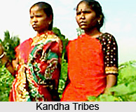
 Culture of Kandhamal District is constituted by the arts, crafts, fairs, festivals, traditions and lifestyle of the native people. The culture of Kandhamal District is unique and diverse. The major inhabitants of Kandhamal District are Kond Tribes. This tribal group is also known as Kandha Tribes. Those living on the hill tops are named as Kandha. According to the 2001 census the scheduled tribe population of the district is 3.36 lakh which constitutes 51.96 per cent of the total population.
According to the area of habitation Kandhas are classified into some classes namely Kutia, Malua /Malia, Dongria and Desia. The Kutia Kandhas are found mainly in Kotgarh, Tumudibandh and Belgarh area of Balliguda sub-division. The Dongria live in high lands of hilly area in the district. The dresses and costumes of the Kandhas are very simple. Ornaments like gold and silver necklaces, ear-rings, nose-rings are very popular. Colored beads are generally used to prepare necklaces. Agriculture is main occupation of the people of this tribe. They still practice primitive method of cultivation i.e. shifting cultivation. Turmeric, Ginger, Arrowroot and other spices are mainly produced here.
Fairs, festivals, music and dance form an important part of the culture of Kandha Tribes. Krahenda is a hunting and warrior dance popular among this tribal group. Drums and flutes are the instruments used. Danda Nata and Loar-Enda are other popular tribal sance of the district. Silver coin chains, bangles and a musical instrument known as Dheka are used for performance. The popular fairs and festivals of Kandhamal District include Mati Puja, Kandula Jatra, Balli Jatra, Rhas Jatra, Kali Puja, Dussehra, Shivaratri, Ratha Yatra, Thakurani Yatra, Laxmi Puja, Danda Nata, Baruni Yatra, Kendu Yatra and more.
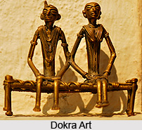
Art and Craft forms a rich part of the culture of Kandhamal District. The various forms of art and craft are as follows -
Dokra Art: This art form is very popular in this district; it is made up of brass.
Terracotta Art: Another popular art form of the region.
Cane and bamboo craft: Cane and bamboo work is found throughout the district.
Stone Craft: This form of art is mainly found in Pusangia where stone ornaments are prepared.
Weaving: Handloom weaving is commonly practiced in the district.
Hence, it is quite clear that the culture of Kandhamal District is enriched with diverse forms of art and craft, indigenous traditions and beliefs of the tribal people.
Tourism in Kandhamal District
 Tourism in Kandhamal District means a lively and memorable experience for the travellers visiting this place. Kandhamal District is bestowed with the beauty of nature. It has all the ingredients for providing a perfect tourism experience like diverse wild life, scenic beauty, healthy climate and twisting ghat roads. Tourism in Kandhamal District implies a relaxing and rejuvenating experience. The major attractions include panoramic coffee gardens, pine jungles, hills, water falls, virgin forests and typical tribal village life. Almost 66 per cent of the land area of the district is covered with dense forests and towering mountains which provide shelter to the inhabitants like Kondhas, classified under the ancient Gondid race of proto Austroloid group. Kandhamal District is also famous for handicrafts such as Dokra, Terracotta, Cane and Bamboo works. The region is proud of its rich cultural heritage.
The popular places of interest of Kandhamal District are as follows -
Phulbani: It is a perfect place to relax and unwind as it is surrounded by hills. The Pillasalunki River flows on its three sides and the town is just on the grove of sal trees. Main attractions of the town are its weekly Hata, Jaganath and Narayani Temple.
Putudi Waterfall: Putudi is a place of natural beauty where river Salunki falls from the height of 60 ft forming an enchanting ambience. The roaring sound of the fall with dense forest all around creates a thrilling sensation. It is around 15 kms away from Phulbani town.
Balaskumpa: The beautiful place in the lap of nature is famous for Goddess Barala Devi who is believed to be the savior of the world. Pillasalunki Dam site which is an ideal and charming place for picnic and sight seeing is only 3 kms from this place. This spot is a good place to relax and unwind.
Chakapad: It is located on the bank of river Burtunga and offers a panoramic view of nature. This place is famous as an important centre of Saivism. Lord Shiva is worshipped here as Birupakshya, Anandeswara and Jageswara with great dedication and reverence in three different magnificent temples.
 The striking features of this place are that the trees around it and Siva linga inside lean towards south. The festivals like Shivaratri, Sitalsasthi and Rasha Purnima are celebrated here.
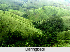
Daringbadi: Daringbadi, a vast area at the height of about 3000 ft above the sea level is gifted with natural bounties such as pine jungles, coffee gardens and beautiful valleys. It is the only place in Orissa which experiences snow fall during winter. The journey from the plains to the hills of Daringbadi is an experience in itself. This pretty hill station is located at 100 kms from Phulbani and 50 kms from Balliguda.
Belghar: Gifted with ample scenic beauty, Belghar presents a panoramic view of the nature. It is inhabited by Kondha tribe. Belghar, situated about 2555 ft above the sea level, is completely suitable for adventurous trekking. Belghar is at 165 kms away from Phulbani and 70 kms from Balliguda. This area is also famous for cane works.
Katramala: A place of natural beauty with a waterfall and pond where one can play with fibres amidst dense forest. It is an ideal place for picnic. The spot is 35 kms away from Phulbani.
Kalinga: This is a picturesque and charming place. The nearby Silviculture Forest Research Station is an added attraction. It is an ideal picnic spot located at 50 kms from Phulbani.
Kandhamal District is also known for its Archaeological Sites. There are so many evidences of Buddhism in this district. The site is rich with several archeological sites which are yet to be explored. It is believed to be a site of 8th or 9th centuries AD. Later it has been changed to a Siava site during the patronage of next Somvanshi rulers.
Recently updated articles in States of India

History of Thissur District
Early History of Thissur District explains flourishing of the port cities. Now these port cities are transformed into archaeological sites.

Tippi Orchid Research Centre, Arunachal Pradesh
Tippi Orchid Research Centre in Arunachal Pradesh is renowned for its rich collection of exotic and endangered orchids. Surrounded by lush rainforest...

Tourism in Nashik District
Pilgrimage tourism in Nashik district involves visiting the various places of Hindu and Jain worship located here. Some of the holiest sites for Hind...

Mangadu, Kerala
Mangadu in Kerala’s Kollam district is a significant megalithic site known for its urn burials, cist burials, menhirs, and stone circles. Excavations...

Devaswom
History of Devaswom is not very ancient and can be dated back to late seventeenth century.
Related articles in States of India

East Indian States
East Indian States comprises of Bihar, Jharkhand, West Bengal, Odisha and also the Union Territory of Andaman and Nicobar Islands. It defines the cult...

Purnia District in Bihar
Purnia District is located in Bihar and extends from River Ganga to Nepal. The district has a rich Hindu history and glorious past.

Hooghly district
Hooghly District along the bank of the river Hooghly is one of the principal trading ports of West Bengal.

Geography Of Chittoor District
Geography of Chittoor district is spread along the topography of the land which is divided into two natural divisions; Chittoor has a dry and healthy...

Districts of West Bihar
Districts of West Bihar is comprised of medieval monuments that were built by the different governors of Mughal era.