 Jabalpur is one of the largest districts in Madhya Pradesh with the administrative headquarters in the city of Jabalpur. It is located in the center of Madhya Pradesh covering an area of 10,160 sq. km. Geographically the region is a part of the Mahakoshal region of Madhya Pradesh. The language spoken here is Hindi. The district is a part of the Jabalpur Division.
The region consists of a long narrow plain running from northeast end to the southwest and is closed on all sides by highlands. It forms an offshoot from the Narmada River valley and the western and southern portions of the plain are covered with a rich alluvial deposit of black cotton and soil. The northern and eastern part of the plain belongs to the Basin of Son River and the southern and western part belongs to the Narmada basin.
The district has an industrial and an agricultural base. The primary industry in the district is the textile industry. Other important industries in the region are bidi, limestone, electrical and food processing industries. The district is a prime tourist destination and tourism sector is a major source of revenue for the district.
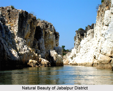
The holy Narmada River is the main water source for the district and the multipurpose Bargi Dam project is located on this river. One of the prime attraction in the district is the Madan Mahal Fort built by the Gond tribe ruler Raja Madan Shah. The tourist site Bhedaghat located in the city of Jabalpur houses the Dhuandhar Waterfalls and the world famous Marble Rocks. The Marble rocks at Bhedaghat rise hundred feet on either side of the Narmada. The quaint loveliness of these white rocks produces a dazzling effect on moonlit nights. The holy river Narmada flows calmly and at a little distance plunges in a mighty waterfall known as Dhuandhar. Devotees visit the Chausat Yogini Temple, the temples of sixty-four goddesses.
This article is a stub. You can enrich by adding more information to it. Send your Write Up to content@indianetzone.com


