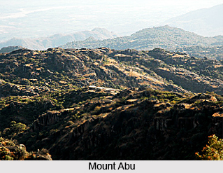
 History of Sirohi district has been long and rich. The name Sirohi has been derived from from the Siranwa hills, on the western slope of which it stands. It might also have been derived due to its position at the head (Sir) of the Thar Desert (Rohi). The name may also have been derived from sword, and this has led some people to believe that this state of the brave Deora Chauhans received it present name due to the wide spread fame of its swords. Mount Abu was one of the most powerful kingdoms at one point in time. Abu formed a part of the empire of Chandragupta Maurya of the Mauryan Empire, who ruled early in the 4th century B.C. The territory of the Abu passed successively to the possession of the Imperial Guptas, the Vaisa dynasty of which Emperor Harsha Vardhan was the main ruler, the Chaoras, the Solankis and the Parmars. From the Parmars, the Chauhans of Jalore took over the kingdom at Abu. Lumba, a scion of the younger branch of the Chauhan rulers at Jalore, seized Abu from the Parmar king in the year 1311 A.D. and became the first king of the territory now known as the kingdom of Sirohi. The famous town of Chandravati situated on the bank at the Banas River, was the capital of the kingdom and Lumba took his residence there and ruled till 1320 A.D.
Rao Shiv Bhan popularly known as Shobha, the Sixth descent from Lumba, finally abandoned Chandravati and founded a town below the Siranwa hill and built a fort on the top in the year 1405 A.D. The newly founded town was called Shivpuri. Relics of the old city are found there and a previous place of Virji is still a place of worship. But the town founded by Rao Shiv Bhan was unhealthy, so, his son Rao Sahasmal abandoned it in 1425 A.D. and built the present town of Sirohi and made it the capital of the kingdom. He laid the foundation stone of the fort of Sirohi on the second day of Baisakhi in the Vikram Samvat era 1482, i.e. 1425 (A.D.) on the top the present town of Sirohi and made it his capital. Later all the area under the Deoras came to be known as Sirohi. In the tradition of the Indian Puranas this area has always been referred to as `Arbudh Pradesh`. It was also sometimes known as Arbudanchal. It is believed that Rishi Vasistha retired to the southern spur at Mount Abu after his sons had been slain by Vishvamitra. During the reign of Rao Sahasmal, the famous Rana Kumbha of Mewar attacked and conquered Abu, Vasanthgarh and the area adjoining Pindwara. Rana Kumbha renovated a castle in Vasanthgarh and also a tank and a temple at Kumbhaswami near the shrine of Achaleshwar in the year 1452 A.D. Rao Lakha succeeded Sahasmal and tried to liberate the region of Abu with the help at Qutbuddin, the king at Gujarat who was also unfriendly with Kumbha. But Lakha failed to get his territory back.
The political awakening in Sirohi started in 1905 with the Samp sabha of Govind Guru who worked for the upliftment of the tribals of Siorhi, Palanpur, Udaipur and former Idar state. In 1922 Motilal Tejawat organized Eki Movement to unite the tribals at Rohida, who were oppressed by feudal lords. This movement was quelled ruthlessly by the state authorities. In 1924-1925 Nav Paragna Mahajan Association presented an application against unlawful Lagbag and Tax System of the Sirohi State. This was the first time that the merchants formed an association and opposed the state. In 1934 Sirohi Rajya Praja Mandal was founded at Ville Parle, in Mumbai under the leadership of journalist Bhimashankar Sharma Padiv, Virdhi Shankar Trivedi Kojra and Samrathmal Singhi Sirohi. Later on Shri Gokulbhai Bhatt joined Prajamandal in 1938. He along with 7 others founded Praja Mandal at Sirohi on 22nd January 1939. After that all the activities of the freedom movement got guidance from the Indian National Congress and Praja Mandal demanded for responsible Government and Civil liberties. It resulted in the formation of popular ministry under the Chief Ministership of Gokulbahi Bhatt.
With the Independence of India in 1947 the process of integration of princely states of India started. After Independence an agreement was signed between the Central Government and the minor ruler of the Sirohi state and with this state administration of the Sirohi state was taken over by the Mumbai Government from 5th January 1949 to 25th January 1950. The Sirohi state was merged on 16th Nov. 1949 with Rajasthan State. After its final merger with Rajasthan in 1950, an area of 787 Sq. Km. consisting of Aburoad and Delwara tehsils of Sirohi district was renamed with the Mumbai state on 1st November 1956, after the recommendation of the State organisation Commission, which forms the present position of the district.


