Introduction
 Cachar Hills District is the administrative districts of Assam with its headquarters located at Haflong. Cachar Hills District is described as the hilliest and undulated districts of Assam. It occupies an area of 4890 sq kms.
Location of Cachar Hills District
Cachar Hills District is located between latitudes 25 degree 3 minutes north and 25 degree 47 minutes north and longitudes 92 degree 37 minutes east and 93 degree 17 minutes east.
History of Cachar Hills District
As per the history of Cachar Hills District after the commencement of the Constitution of India, North Cachar Hills in 1951, ceased to be a part of Cachar District. According to the provision of sixth schedule, two special councils were created namely Cachar Hills District Council and Mikir Hills District Council. Cachar Hills District Council was established in office on 19th April, 1952. In the year 1970, state government declared Cachar Hills District an independent administrative district.
History of North Cachar Hills District
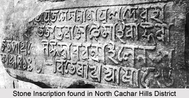 History of North Cachar Hills District refers that this region was a part of Kachari Kingdom before 1832. The kingdom was extended from Yamuna River in the north to the foot-hills of Lushai Hills in the south, from Kopili River in the west and Katcha Naga Hills beyond the Dhansiri in the east. Dimasa Kachari kings had their capitals in succession at Dimapur, Maibang, Kashpur and lastly at Horitikor (Karimganj District near Badarpur). In 1830, Dimasa king Gobinda Chandra was assassinated after that the British East India Company annexed the southern part of the kingdom on 14th August 1832 under the Doctrine of Lapse. Dimasa General Tularam ruled the rest. In the year 1837, a portion of Tularam`s kingdom was further annexed to the British Empire and constituted into a sub-division of Nagaon District in 1837 with its headquarters at Asalu. In the year 1854, after the death of Tularam, the remaining portion of his kingdom was finally annexed to the British Empire and was added to Asalu sub-division.
Historical accounts of North Cachar Hills District also recollects that in the year 1867, Asalu sub-division was abolished and distributed into three parts among the districts namely Cachar District, Khasi Hills and Jaintia Hills and Nagaon District. The present North Cachar Hills district was included in the old Cachar district with Asalu being only police outpost. In the year 1880, this portion was constituted into a sub-division under Cachar district. This headquarter was shifted to Haflong in the year 1895. Since then Haflong continues to be the headquarters of Asalu sub-division. In the year 1951, after commencement of the Constitution of India, North Cachar Hills as specified under Paragraph 20 of the sixth schedule to the constitution, ceased to be a part of Cachar district.
According to the history of North Cachar Hills District, this part along with Mikir Hills constituted a new civil district namely "United District of North Cachar and Mikir Hills" with effect from 17th November, 1951. Further, as per the provision of sixth schedule, two different councils were constituted later on, namely North Cachar Hills District Council and Mikir Hills District Council within the geographical territory of that district. North Cachar Hills District Council was inaugurated on 19th April 1952. Further, on 2nd of February, 1970, government declared an independent administrative district, that is North Cachar Hills District with the geographical boundary of autonomous North Cachar Hills District council. Presently, this autonomous council possesses administrative control over almost all the departments of the district except Law and order, Administration and Treasury Departments.
Geography of Cachar Hills District
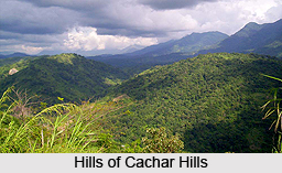
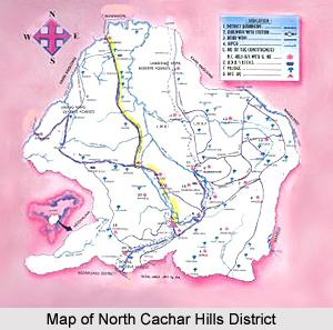
 Cachar Hills District is situated at southern part of Assam. This district is bounded by Nagaland and Manipur in the east, Cachar District in the south, Meghalaya and some parts of Karbi Anglong District in the west and another part of Karbi Anglong and Nagaon District in the north. A major portion of the district is covered by hills. The main range is Borail of which `Thumjang` is the highest peak at 1866 metres and Hempeupet is the second highest peak at 1748 metres. The other main range of the district is Khartheng range from Dittokcherra to Garampani. The main rivers are Kapili, Dehangi, Diyung, Jatinga, Jenam, Mahur and Langting. Diyung River is the longest river with a length of 240 kms.Climate condition of Cachar Hills District is also not uniform. Annual average rainfall varies from 2200 mm to 2700 mm. At this district, rainfall is heavy during May to September, but it is not evenly distributed throughout the district. Average mean maximum temperature varies from 24 degree Celsius to 30 degree Celsius. The average mean minimum temperature varies from 10 degree Celsius to 14 degree Celsius. Further, average relative humidity ranges from 73 percent to 84 percent.
Demography of Cachar Hills District
As per 2001 Census the average of total population of Cachar Hills District is 1, 86,189 that is near about 7 per cent of the total population of the state. The population of the district comprises various tribes and races having their indigenous dialect, culture, customs and usages. Apart from various tribes, non-tribal groups also account for a sizable percentage of the total population of North Cachar Hills District. Among the various tribes, the prominent ones are Dimasa Tribe, Zeme, Hmar Tribe, Kuki Tribe, Baite Tribe and Hrongkhols Tribe.
Education in Cachar Hills District
The literacy rate in Cachar Hills District is around 69 percent as against the state average of 64 percent. Female literacy rate is 59.40 percent and male literacy rate is nearly 76.59. At this district, there are a number of Arts and Science colleges, high schools, teachers training institutes and industrial training institute.
Economy of North Cachar Hills District
 Economy of North Cachar Hills District is not very encouraging. Geographical remoteness, poor communication and lack of proper infrastructural facilities are some of the main factors behind the low level of economic development of this district of Assam. However, in spite of the depressing scenario, prospects of agriculture, horticulture and forestry forming the main sectors of economy of North Cachar Hills District are bright.
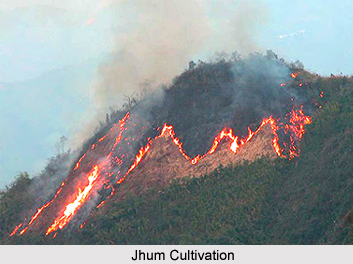
Agriculture contributes heavily to the economy of North Cachar Hills District. Majority of the rural people of the district is dependent upon agriculture. A distinctive feature of the agricultural practices of the tribal people in the district is jhum cultivation, which is the traditional way of their life. This shifting process of cultivation is very popular among the people of this district. Near about 70 per cent of the total cultivated area is under jhum cultivation area. This cultivation is done in autumn season either as a single crop or sometimes as mixed crop along with maize, ginger, turmeric, chillies and other vegetables. Some horticultural crops cultivation, such as pineapple, orange, papaya and banana occupy a vital role in the agricultural economy of the district.
Winter paddy cultivation in flat lands mostly in river valleys is done only in Rabi season. Constant efforts have been made by the Departments of Agriculture, Soil conservation and Irrigation to boost up the agricultural economy. Jhum cultivation has many drawbacks. It turns the hill slopes barren by soil erosion and it is less productive. Some private sector as well as some public sector undertaking has started coffee and rubber cultivation in different localities of North Cachar Hills District. Further, several agro-based industries have been established in the region for enhancing its economy.
Economy of North Cachar Hills District also includes sectors like livestock and poultry. They occupy an important place in the rural economy. Buffalo, pig, etc. are the most common livestock animals while hen and duck comprise the poultry birds. The major forest products consist of timber, cane, bamboo, etc. Boulders and gravels in the riverbeds along with stones are also available. The major industries constituting the economy of North Cachar Hills District include cement factories; saw-mills, etc. These are basically private sector industries of the district. There are four cement plants in this district. Apart from these, weaving is also considered to be a popular household industry in this district. Limestone and coal in small quantity are found in the region. Good quality of limestone, low in magnesia and suitable for cement manufacturing is available in the district.
Thus, it can be said that economy of North Cachar Hills District is mainly agrarian in character.
Administration of North Cachar Hills District
 Administration of North Cachar Hills District is headed by Deputy Commissioner. The administrative set up of North Cachar Hills District comprises two sub-divisions namely Haflong and Maibang. There are two Revenue Circles (Tehsils), namely - Haflong and Maibang. In order to provide better developmental facilities, North Cachar Hills District has been divided into five Community Development Blocks - Jatinga Valley Development Block, Mahur, Diyung Valley Development Block, Maibang, Harangajao ITD Block, Harangajao, Diyungbra ITD Block, Diyungmukh, New Sangbar Development Block, Sangbar. For better administrative control, the district area is divided into four police stations namely Haflong, Mahur, Mabang, Umrangso.
The Deputy Commissioner is in charge of the entire administration of North Cachar Hills District. He also acts as District Magistrate in case associated with maintenance of Law and Order and General Administration, as District Election Officer in matters associated with Election and so on. A number of officers like Additional Deputy Commissioner, Superintendent of Police, Sub-divisional Officers, Extra Assistant Commissioners and others, assist the Deputy Commissioner.
North Cachar Hills District is one of the two hills districts of Assam. The North Cachar Hills Autonomous District Council was constituted under the provisions of the sixth schedule to the Constitution of India to administer this autonomous district. North Cachar Hills Autonomous Council has three wings of administration, namely Legislature, Judiciary, and Executive. Further, Revenue Administration is under the administrative control of the North Cachar Hills Autonomous District Council. The Revenue Officer of the district council looks after this branch. His responsibility mainly includes collection and fixing of land revenue, registration, mutation and overall management in regard to land - private and public.
The Autonomous Council undertakes all the developmental activities in the district. Maintenance of Law and Order is another important aspect of district administration and the Deputy Commissioner also being the District Magistrate, is responsible for proper maintenance of the same. For management and implementation of various developmental schemes, committees are constituted at the level of Town Committees for Urban Areas and Block Level committees in the rural areas. In the rural areas, `Gao Bura` or the headman of the village looks after village administration. The total number of villages in the North Cachar Hills district is around 539.
Tourism in Cachar Hills District
The major tourist attractions of Cachar Hills District include Haflong Town, Maibang (Stone house and temple of Kachari king and other ruins of the kingdom are the main attractions of the place), Jatinga (a place of bird attraction and attraction), Umrangso and Mahur.


