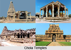
 History of Nagapattinam district speaks of the influence of the Cholas, the Pallavas, the Portuguese, the Dutch and lastly the British till the independence of India. The district of Nagapattinam was formed by the bifurcation of the composite district of Thanjavur on 18th October 1991. It is a unique district with all its historical and cultural significance. This district is one of the constituents of Cholamandalam, acclaimed as the most notable among the ancient Tamil kingdoms. Its salient features have contributed to the glory of the Cholamandalam.
The coastal district of Nagapattinam was the headquarters of a region during the period. This region has been named after Kshatriya sigamani, one of the titles of Raja Raja Chola. Nagapattinam was also known as `Cholakula Vallippatinam`. The heritage of this district is found in the Burmese historical text of the 3rd century B.C. and it also gives evidences of a Buddha Vihar constructed by the great emperor Ashoka. Hieun Tsang, the Chinese traveler also described about the Buddha Vihar in his book. In the ancient Buddhist literature the Nagapattinam district is mentioned as Padarithitha.
In ancient times, `Naganadu`, `Nagapattinam` was referred only to Sri Lanka. Buddhist monks in Sri Lanka had close links with this district of Nagapattinam. `Animangalam Copperplate` of Kulothungachola noted that `Kasiba Thera`, a Buddhist monk, renovated the Buddhist temple in the 6th century AD with the help of Buddhist monks of `Naganadu`. This `nagar annam vihar` later came to be called as `Nagananavihar`.
The Pallava King Rajasimha (A.D. 690 to A.D. 728) permitted a Chinese king to construct the Buddha Vihar in Nagapattinam. Hence there existed a Chinese built Buddha Vihar in the district of Nagapattinam. As per Anaimangalam copper plate of Kulothunga I, Sri Vijayathunga Varman of Sri Vijaya kingdom constructed the Raja Raja Perumpalli in the name of Raja Raja Chola and Rajendra Chola Perumpalli in the name of Rajendra Chola in A.D. 1090. This Buddha Vihar of the district is also known as the Sudamani Vihar. Excavations were conducted by the Archaeological department at Vellipalayam in Nagapattinam and more than three hundred Buddha statues were unearthed and kept at the Museum in Chennai. This dilapidated Buddhist tower was razed down about two hundred years ago.
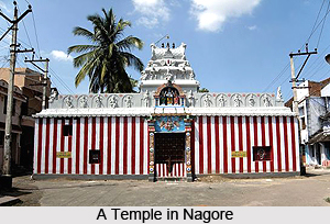
 Nagore, a town of this district, is called so because it was inhabited by the Nagars. The Nagapatinam Kayaroganam Shiva temple existed even in the 6th century. Appar Sambandar and Sundarar were associated with this temple; Kayaroganam Shiva temple is based on the `Laguleesa Pusuptha Cult.` The Soundaraja Perumal Viashnava temple is one of the notable features of Nagapattinam. Portuguese had a commercial contact with this town during the Tanjore Nayakkas rule and the Portuguese commercial centre was established in the year 1554. Since then Christianity began to take root under the commercial contact, and ten villages were taken control of by Portuguese traders.
In the year 1658, the Dutch tried to evict the Portuguese from Nagapattinam to establish the commercial centre there under the agreement reached between King Vijaya Nayakkar of Thanjavur and the Dutch on 5th January 1662. The following ten villages namely Puthur Muttam, Azhingimangalam, Poruvalancheri, Thiruthinamangalam, Anthonippettai, Nagappattinam Port, Karureppankadu, Sangamangalam, Manjakollai and Nariyankudi were transferred from the Portuguese to the Dutch.
Ten Christian churches and a hospital were constructed by the Dutch. They also released coins with the name Nagapattinam; engraved in Tamil letters. According to the agreement between the first Maratha King `Egoji` of Tanjore and the Dutch, Nagapattinam and surrounding villages were handed over to the Dutch on 30th December 1676. Latter this town fell into the hands of the British in the year 1781. After the prolonged struggles, two hundred and seventy seven villages with Nagur as the headquarters were handed over to the British East India Company in 1779. Gold coins bearing the names `Nagapattinam Varagan` and `Nagapattinam chornam` were in circulation during the period of Tanjore Maratha Kings. Thus the Nagapattinam has the history of over two thousand years to its credit. Today the district of Nagapattinam is a part of the Tamil Nadu state of India.
The total area covered by this district is 2715.83 square kilometers and the headquarters of this district is Nagapattinam. Among the Chola kings, King Karikalan renovated and constructed the renowned port of Poompuhar with is located presently in the district of Nagapattinam.
History of Nagapattinam District
History of Nagapattinam covers a period of two thousand years and it narrates the glorious past of the place which saw the rule of the Cholas, the Portuguese, the Dutch and also the rule of the British East India Company.


