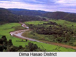
Tourism in Dima Hasao District provides a beautiful voyage around the mesmerizing natural beauty. The exquisite hues of nature in the district blend beautifully with the hospitality of the local folks and makes the tourist experience highly alluring. Lush greenery, majestic hills and wandering clouds obscuring the mountains are a treat to the eyes. The rich cultural heritage of the district and its colourful festivals adds to the essence of tourism and makes the place immensely inviting.
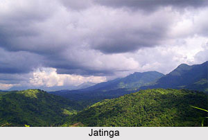 Jatinga :
 Jatinga is a small village adorned with magnificent landscapes. It is especially famed for its mysterious migratory birds which arrive in the district in the month of August and September, making the place picturesque and colourful. The place is also intriguing owing to the sad phenomenon of the suicide of migratory birds in this place. It is said that in the moonless foggy night accompanied by gentle drizzle, when the breeze blows from south to north, these migratory birds commit suicide and descend to the ground. Several explanations have been put forth by the scientists in favour of this phenomenon. According to a theory, certain weather conditions provoke this activity while another theory proposes that the phenomenon is completely natural and occurs to maintain a balance in the number of migratory birds. Horticulture products and orange gardens of the place are also popular.
 Dream Valley of Umrongso :
 The Dream Valley of Umrongso is another place in the district exhibiting breathtaking natural beauty. The pinnacles of the hills veiled behind the mists are a wondrous sight to experience. Pine plantations and their fragrance ferried by the gentle breeze are intoxicating. Sunset in Umrongso is also marvellous to watch where the sunrays reflect over the water creating a dazzling view. Kopili River in the region hosts a hot water stream which is believed to possess medicinal values. A forest reserve situated nearby houses a number of wild animals. Kopili Tea Estate is another tourist attraction of this place. It also houses several cement plants and is a flourishing industrial area.
Panimoor : Panimoor is famed for its beautiful waterfall of Kopili River. The place is considered very sacred by
Dimasa tribe. During Magh Purnima the tribal people take a holy bath in this waterfall.
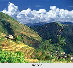
Haflong : Haflong is often known as the Switzerland of the East. It is the district headquarters and queen town, embraced by resplendent nature. The city is beautifully bordered by the Barail Hill for which it is often also termed as the `Land of Blue Hills`.
Garampani : Garampani is located at the western end of the district, along the eastern bank of River Kopili. The place derives its name from a hot spring situated here. It also houses a stunning water fall originating from the River Kopili.
Mahur : Mahur is well known for hosting the longest railway tunnel of
Northeast frontier Railway line, stretching to a length of 1192 feet. Mahur is also famous for its
coffee plantation which has a great demand not only in India but also in the whole world.
 Hajong :
 Hill terrapins belonging to a rare variety are found in a large number in Hajong. Reserve Forest of Langting Mupa is also located here and houses the Hajong Lake. Several rare varieties of tortoises are found in the lake.
Thuruk : Thuruk is another captivating place of the district, famous for snowfall. Apart from being popular among trekkers and mountaineers, the hospitality of the villagers has also made the village an inviting place for tourists.
Harangajao : Harangajao had once been the cultural centre of Dima Hasao District. It is also renowned as the prime producer of delicious pineapples.
Laisong : Laisong houses the largest traditional dormitory of
Naga tribe, known as Hangseuki. The culture and traditions of the tribe has been well preserved by the dormitory since ages.
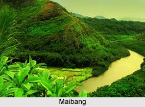
Maibang : Maibang is historically very significant as it served as the capital of Dimasa kingdom during late 16th century. The city is situated at the heart of the district and River Mahur flows nearby. The main attraction of Maibang is however the Mahur Valley which stands amidst the dense forest. It is an ideal place for nature lovers and nature photographers. A walk on the green carpet of the Mahur Valley and an evening on the bank of River Mahur can be some of the most appeasing experiences of life.
Heritage Village near Jatinga : mHeritage Village has recently emerged as an attractive tourist attraction. It is famous for sketching the diverse cultures, traditions and heritage of different tribes of the district and the harmony which exists among them. Traditional houses and dormitories belonging to various tribes are also found here.
Nature in the Dima Hasao district pictures sights to be treasured for life. The assemblage of cultural and natural diversity in the district entices a number of tourists from distant places. Tourism in Dima Hasao District offers a plethora of unique and delightful experiences to the tourists.
 Dima Hasao district is an administrative district in the state of Assam in north-eastern India. Haflong is the district headquarters of this district. Dima Hasao district occupies an area of 4,888 square kilometers.
 In 1867, the subdivision of Asalu was abolished and was divided and allocated to the districts
  People of Dima Hasao District have adopted a variety of cultures, traditions and practices. Dima Hasao District houses a number of tribes and races and consequently a plethora of cultures, rituals, practices and dialects. Population of non tribal people is also considerable in the district which comprises of mostly traders and government employees dwelling in urban and semi urban areas. Tribal population of the district have prominent cultures and lifestyles which make them unique in their own way.
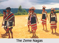 Zeme Nagas Tribe
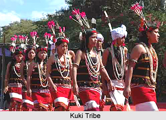
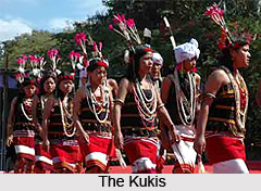 Kukis Tribe


