
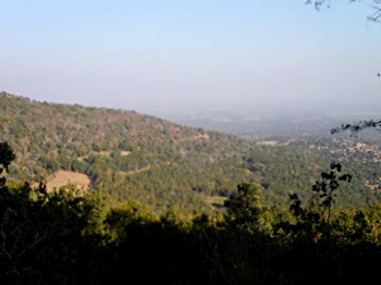
 Geography of Shahdol district is filled with exuberant green forests. Located in the range of Vindhyachal, the district is rich in natural wealth of coal, minerals, etc. The district holds a vast reserve of coal mines. The district of Shahdol is situated in the North-Eastern region of the state of Madhya Pradesh in India. Due to the division of the district on 15th August 2003, the area of the district remains five thousand six hundred and seventy one square kilometres. This district is surrounded by Anuppur in the South-East, Satna and Sidhi in the North and Umaria in the West. The Shahdol district extends one hundred and ten kilometers from East to West and one hundred and seventy kilometres from North to South. The district of Shahdol is located in between twenty two degree thirty eight minutes and twenty four degree twenty minutes to the North Latitudes and between thirty degree twenty eight minutes and eighty two degree twelve minutes to the East Longitudes.
The district of Shahdol is largely considered to be a hilly district. It is known for its beautiful natural setting with certain belt and pockets of Sal and mixed forests. The total geographical area of this district is 5671 square kilometers. Adjacent to it, the bordering districts are Satna district, Umaria district, Sidhi district, Anuppur district, Rewa district and Dindori district. This district in the state of Madhya Pradesh is situated in the north-eastern region of the Deccan Plateau. It is situated at the tri-junction of the foot of the Kymore Range of the Vindhya Mountain, Maikal Ranges of the Satpura Mountain and a mass of parallel hills which extend over the Chota Nagpur Plateau in the state of Bihar. In between these hill ranges is located the narrow valley of the Son River and its tributaries. As the Kymore Range extends along the Son River just across the northern boundary, the Shahdol district may be divided into three physiographic divisions like the Maikal Range, the Upper Son Valley and the Hills of Eastern Plateau.
The district of Shahdol is rich in its mineral resources. Minerals found in the district are coal, ochers, fire clay and marble. District coal mines contribute a major part in the revenue of the state. This district is backward in the field of agriculture. Tribals of the district prefer the cultivation in the old traditional method. The size of the agricultural fields is very small and mainly the tribals are marginal farmers. The yearly yield of the products from the fields is not enough for their home use. Hence, for the rest part of the year they work on daily wages.









