 Rae Bareli District, an administrative district of Uttar Pradesh, forms a part of the Lucknow Division. Rae Bareli is the district headquarters. The elevation of Rae Bareli District varies from about 120.4 metres above sea level in the north west to 86.9 metres above sea level in the extreme south east, on the banks of the Ganga. Economy of Rae Bareli District is agrarian in character. Paddy is the main Kharif crop and wheat is the main Rabi crop in the district. Sugarcane and potato are the main cash crops cultivated in the district.
Rae Bareli District
Rae Bareli District is one of the six districts of Lucknow Division. Rae Bareli District of Uttar Pradesh enjoys a very long history of traditional arts. From the literary point of view Rae Bareli District has always been in a high position throughout the nation.
Introduction
Rae Bareli District, an administrative district of Uttar Pradesh, forms a part of the Lucknow Division. Rae Bareli is the district headquarters. The elevation of Rae Bareli District varies from about 120.4 metres above sea level in the north west to 86.9 metres above sea level in the extreme south east, on the banks of the Ganga. Economy of Rae Bareli District is agrarian in character. Paddy is the main Kharif crop and wheat is the main Rabi crop in the district. Sugarcane and potato are the main cash crops cultivated in the district.Location of Rae Bareli District
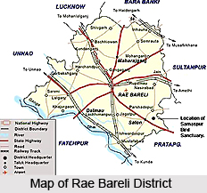
Rae Bareli District lies between 25 degree 49 minutes north and 26 degree 36 minutes north latitude and 100 degree 41 minutes east and 81 degree 34 minutes east longitude. Rae Bareli District is bounded on the north by tehsil Mohanlal Ganj of District Lucknow and tehsil Haidergarh of Barabanki District, on the east by tehsil Musafirkhana of district Sultanpur and on the south east by Pargana Ateha and the Kunda tehsil of district Pratapgarh. The southern boundary of Rae Bareli is formed by Ganga River which separates it from Fatehpur District. On the west lies the purwa tehsil of Unnao District.
History of Rae Bareli District
According to the history of Rae Bareli District, this district was created by the British government in 1858. This district is named after its headquarters town Rae Bareli. History of Rae Bareli District also states that the town was founded by the Bhar and was known as Bharauli or Barauli which in course of time got transformed into Bareli. The prefix, Rae, is said to be a version of Rahi, a village 5 km west of the town. It is also said that the prefix, Rae, represents Rae, the common title of the Kayasths who were masters of the town for a considerable period of time. Further, since the beginning of the medieval period of Indian history the region in the south of which the area covered by the district of Rae Bareli lies has been known as Avadh. In the north it is stretched as far as the foothills of the Himalaya Mountains and in the south as far as Ganga River. It has been stated that the district has been civilised since pre-historic times.
History of Rae Bareli District does not talk much about the administrative status of the district prior to the Muslim invasion, except that it formed part of Kosala, ancient state of northern India. At the beginning of the 13th century AD, what is now Rae Bareli and the tracts around it were ruled by the Bhars who were displaced by the Rajputs and, in a few places by some Muslim rulers. The south western part of the district was occupied by the Bais Rajputs. The Kanpurias and Amethias, other Rajput clans, established themselves respectively in the north east and east. During the rule of the Delhi sultans nearly the whole tract nominally formed a part of their kingdom. During the reign of Akbar the area now covered by the district was divided between the sirkars of Avadh and Lucknow in the subah of Allahabad, the sirkar of Manikpur which included the larger part of the district as it extended from the present Mohanlal Ganj Pargana of Lucknow District on the north west and to Pargana Inhauna on the north east. In 1762, the sirkars of Manikpur were included in the territory of Avadh.
In 1858, it was proposed to form a new district with headquarters at Rae Bareli, as a part of the Lucknow Division. The district, as then constituted, was very different in shape and size from the existing one and was divided into four tehsils, Rae Bareli, Haidergarh, Bihar and Dalmau. Further, during the freedom struggle of the country, Rae Bareli District played a significant role.
Geography of Rae Bareli District
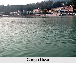 Geography of Rae Bareli District includes fairly compact tract of gently undulating land. The highest points of the district are the crowns of the watersheds of the different drainage channel which serve to divide the district into five main physical units namely Ganga Khadar, Ganga upland, southern clay tract, central tract or Sai upland and northern clay tract. Geography of Rae Bareli District also comprises river systems and several water resources. The district is drained by Ganga River, Sai River and their tributaries although some of them join the main stream after passing the confines of the district.
Rae Bareli District forms a part of Indo-Gangetic plain according to geological chronology and reveal ordinary Gangetic alluvium. The district being a part of the alluvial plain conforms to the same geological sequence as the plain itself. The only mineral of importance is Kanker. The district is also noted for its deposits of brick earth. As this district lies in the vast Gangetic plain of north India at an elevation of around 100 to 120 metres, sloping gently to south east. Relief from the summer heat arrives with the monsoon usually in the second half of June, through the weather may often remain humid. The winter sets in November and last up to February generally. The climate of Rae Bareli District is almost dry. Annual rainfall is about 900 to1000 mm which is mainly during the period of July to September.
Ganga River, which is the only main river in the district touches it in the extreme west of Pargana Sareni in tehsil Dalmau and, forming the southern boundary of the district, runs south east as far as village Barua. The main tributaries of River Ganga are Loni (this large stream which rises in Unnao District and enters Rae Bareli in the west) and Chob (this stream rises on the southern side of the district). Mathna Nadi is another tributary of GANGA River in the district. This is a small stream which rises in the swamps of Pargana Dalmau. It runs southward in a twisted course for several kms to the west of Dalmau. Sai River is another river traversing through Rae Bareli District. The total course of the river in the district is near about 100 kms. The major tributaries of Sai River are Kathwara Naiya, Nasirabad Naiya, Basaha, Soh and Semrauta Naiya.
Groves in Rae Bareli District consist mostly of mango and mahua trees. Flora and fauna have greatly decreased in number and variety in the district during the past century. However, different varieties of snakes and other reptiles are found everywhere in the district especially in the rural areas.
Administration of Rae Bareli District
The general administration of Rae Bareli District is vested in the Deputy Commissioner for revenue and District Magistrate for criminal jurisdiction. District Magistrate is assisted by Additional District Magistrate (Executive) for administrative works and revenue purpose. Rae Bareli District has seven sub divisions namely Rae Bareli, Lalganj, Dalmau, Tiloi, Maharajganj, Unchahar and Salon. Each sub division also forms a tehsil of same name. Further, each sub division serves the purpose of General, Criminal and Revenue Administration of the district. There are seven Sub Divisional Magistrates under the District Magistrate, each holding charge of a sub division and performing multifarious duties relating to revenue, executive and magisterial work as well as those connected with the development of the area under his respective jurisdiction. For law and order and other administration purpose in Rae Bareli a City Magistrate is also functioning at district headquarters. For development purpose the district has been divided in 21 development blocks namely Amawan, Bachhrawan, Bahadurpur, Chhatoh, Deeh, Deen Shah Gaura, Dalmau, Harchandpur, Kheeron, Lalganj, Maharajganj, Jagatpur, Rahi, Rohaniya, Sareni, Salon, Sataon, Singhpur, Shivgarh, Tiloi and Unchahar.
Tourism in Rae Bareli District
 Tourism in Rae Bareli District gives the opportunity to explore several historically significant sites. Moreover, it also offers visits to nature parks and bird sanctuaries. Tourism in Rae Bareli District offers a refreshing and memorable experience to the travellers. This district is known for its rich traditional history and it is a popular tourist destination.
The major attractions of Rae Bareli District are mentioned below -
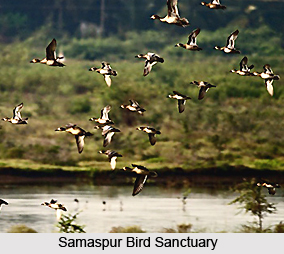
Samaspur Bird Sanctuary: Samaspur Bird Sanctuary is situated in Rohaniya Development block of the district, about 122 km from Lucknow on Lucknow-Varanasi highway. It was established in the year 1987 on a total area of about 799.371 hectare. Nearest railway station is Unchahar and the nearest airport is Fursatganj, Rae Bareli. The best period for visiting this bird sanctuary is from November to March. More than 250 varieties of birds can be seen here. Some of the birds come here from a distance of 5000 km. Local birds include Comb Duck, Whistling Teel, Spot Bill, Spoon Bill, Kingfisher, Vulture etc. Moreover, twelve varieties of fish are there in the lake at Samaspur.
Dalmau: Dalmau is situated on the banks of Ganga River and is famous since ancient times. It has been the historical town of the district. Prominent places of interest at Dalmau are King Dal`s Fort, Bara Math, Mahesh Giri Math, Nirala memorial Institute, A well constructed by Ebrahim Sharki, Palace of Nawab Shuza-ud-daula, Baithak of Alhaa Udal, Dalmau Pump canal, etc.
Indira Gandhi Memorial Botanical Garden: Indira Gandhi Memorial Botanical Garden was established in the year 1986 in order to restore the ecological balance. The garden is situated on the left side of Lucknow-Varanasi highway. This garden is situated on the northern bank of Sai River. Total proposed area of the botanical garden is 57 hectare, out of which 10 hectare has been developed till now and it is growing day by day. The purpose of garden is not merely to make it a place for growing flowers, fruits or vegetables but also an educational installation for awakening interest in plant life among the people. Rock garden, Rose garden, Seasonal plant garden, aquatic garden and a greenhouse are included in this botanical garden.
Behta Bridge: Behta Bridge is situated in the outskirts of the Rae Bareli city. One of the important features of this Bridge is that at this place Sharda canal crosses the Sai River. An aqueduct has been constructed and the canal flows in the duct.
Jais: Jais is an ancient city of the district. Once upon a time it was the capital of King Udyan. Malik Muhammad Jayasi, a great poet belonged to this place. In his memory `Jaisi Samrak` has been constructed there.
These tourist places offered by Rae Bareli District are worth visiting and they attract visitors from all parts of the country.
Recently updated articles in States of India

History of Thissur District
Early History of Thissur District explains flourishing of the port cities. Now these port cities are transformed into archaeological sites.

Tippi Orchid Research Centre, Arunachal Pradesh
Tippi Orchid Research Centre in Arunachal Pradesh is renowned for its rich collection of exotic and endangered orchids. Surrounded by lush rainforest...

Tourism in Nashik District
Pilgrimage tourism in Nashik district involves visiting the various places of Hindu and Jain worship located here. Some of the holiest sites for Hind...

Mangadu, Kerala
Mangadu in Kerala’s Kollam district is a significant megalithic site known for its urn burials, cist burials, menhirs, and stone circles. Excavations...

Devaswom
History of Devaswom is not very ancient and can be dated back to late seventeenth century.
Related articles in States of India

East Indian States
East Indian States comprises of Bihar, Jharkhand, West Bengal, Odisha and also the Union Territory of Andaman and Nicobar Islands. It defines the cult...

Purnia District in Bihar
Purnia District is located in Bihar and extends from River Ganga to Nepal. The district has a rich Hindu history and glorious past.

Hooghly district
Hooghly District along the bank of the river Hooghly is one of the principal trading ports of West Bengal.

Geography Of Chittoor District
Geography of Chittoor district is spread along the topography of the land which is divided into two natural divisions; Chittoor has a dry and healthy...

Districts of West Bihar
Districts of West Bihar is comprised of medieval monuments that were built by the different governors of Mughal era.