Home > Travel > States of India > East Delhi district
East Delhi district
The East Delhi district is one of the densely populated areas in Delhi.

Share this Article:

East Delhi district
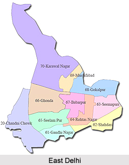
East Delhi district is located on the banks of the Yamuna River. It shares its border with two important cities of Uttar Pradesh, Noida and Ghaziabad. Spread over an area of 364 sq. km. the district has an extreme climate and the temperature varies from 45° C in summer and 4° C in winter.

The main languages spoken here are Hindi, English, Urdu and Punjabi. It is well connected to other parts of Delhi through a network of bridges. Frequent bus services are available from East Delhi to rest of Delhi. Vikas Marg, Gandhi Nagar, Lakshmi Nagar, Preet Vihar and Shahdara are some of the significant commercial centres in the district. The district also has three major sport complexes.

According to the 2011 census of India, East Delhi has a population of 1,707,725 which is roughly equal to any small nation like Vatican City or Gambia. This gives it a ranking of 284th in India. The districts of East Delhi have a population density of 26,683 residents per square kilometre. Its population growth rate over the decade 2001-2011 was 16.68%. East Delhi has a sex ratio of 883 females for every 1000 males. The literacy rate of East Delhi is 88.75%. Most of the hamlets of East Delhi are dominated by Gurjars Gotra of Dedhar. Dedhar have 24 villages in East Delhi.

The most tourists` attractive site is Akshardham Temple, which is one of the biggest temples in the world. Other attractive sites are Laxmi Nagar Market, Cross River Mall, V3S Mall, Sanjay Lake, Gandhi Nagar Market, Lal Quarter Market, Yamuna Sports Complex,Krishna Nagar and Shiv Mandir of Preet Vihar.

In this district there are many hospitals and health institutions like Guru Tegh Bahadur Hospital, Delhi State Cancer Institute, Institute of Human Behaviour & Allied Sciences (IHBAS), Dr. Hedgewar Arogya Sansthan and Lal Bahadur Shastri Hospital, Khichripur.


Share this Article:

Related Articles

More Articles in States of India


East Indian States
East Indian States comprises of Bihar, Jharkhand, West Bengal, Odisha and also the Union Territory of Andaman and Nicobar Islands. It defines the cultural heritage, rich historical background and the linguistic unity.
Erode District
Erode District is one of the districts in the state of Tamil Nadu. The district of Erode is having a land-locked area with no sea coast.
Purnia District in Bihar
Purnia District is located in Bihar and extends from River Ganga to Nepal. The district has a rich Hindu history and glorious past.
South Delhi District
South Delhi District is the third largest district of Delhi as far as its area is concerned. South Delhi District is known for its economic, historical, cultural and social significance.
North Indian States
North Indian States formed the cultural and religious unity in spite of having many foreign invasion and the political disturbances from the early era till the British gained supremacy in Indian sub continent.
Kendujhar District
Kendujhar District, spread over an area of 8,240 sq kms, is as varied as the whole of Orissa with waterfalls roaring gorges, mountains and minerals. The manifold expressions of nature in Kendujhar District are considered as unique.
Hooghly district
Hooghly District along the bank of the river Hooghly is one of the principal trading ports of West Bengal.
Districts of South Tamil Nadu
Districts of South Tamil Nadu consist of many tourism destinations like archaeological sites and the history of Pandyas and Cholas. Considering their proximity to the sea, many districts also boast of serene beaches and coastal beauty.
Flora of Arunachal Pradesh
Flora of Arunachal Pradesh includes infinite species and is a subject of great interests for the botanists.
Districts of South Gujarat
Districts of South Gujarat are the epicenter of Jain pilgrimages and the early Hindu kingdoms.
North West States of India
North West States of India consist of three states, which are Rajasthan, Punjab and Haryana. All of them are culturally and traditionally diverse and they have been ruled by different dynasties in historical time.
Geography Of Chittoor District
Geography of Chittoor district is spread along the topography of the land which is divided into two natural divisions; Chittoor has a dry and healthy climate.
Districts of North Rajasthan
District of Northern part of Rajasthan is dotted with ancient forts and medieval villages.
Districts of North Odisha
District of North Odisha has Bengal boundary and shares the same culture. These are reachable if one pays a weekend visit to Digha.
Districts of West Bihar
Districts of West Bihar is comprised of medieval monuments that were built by the different governors of Mughal era.
Districts of South Haryana
Districts of South Haryana consists of many cities of industrial excellence. These districts are dotted with popular tourism destinations.
Medieval History of Assam
Medieval history of Assam narrates the advent and rule of a number of kingdoms in the region. The prominent dynasties of the kingdom left an everlasting imprint on the socio cultural heritage of India.
Geography of Meghalaya
The suitable climate, highland plateaus, rivers and the flora and fauna together forms the geography of Meghalaya.
Districts of Rayalaseema
Districts of Rayalaseema in Andhra Pradesh state has urban population and rural settlements as well.
Districts of South Punjab
Districts of Southern part of Punjab depict medieval history of Punjab and the rise of Sikhs.