Introduction
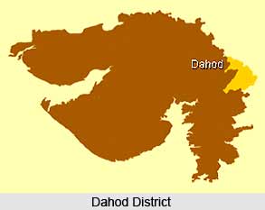 Dahod district of Gujarat is spread across 7 talukas and Dahod taluka is the district headquarters. The total area of the place is 3,733 sq. km. As per 2001 census the total population of the district is 1.63 Million with 438 Persons per sq. km. Dahod district is the second largest wholesale grains market in Gujarat. The major tourist destinations of the district are Chhab Lake, Aurangzeb`s Fort, Ratanmahal Sanctuary, the Shiva Temple at Bavka, etc.
Geography of Dahod District
Dahod district shares its border with Rajasthan state in the north and Madhya Pradesh state in the east. Geographical location of the place is 20.30 degree to 23.30 degree North (Latitude) and 73.15 degree to 74.30 degree East (Longitude). Average rainfall is 1107 mm and the major rivers of this place are Anas, Panam, Macchan and Kali.
History of Dahod District
 History of Dahod District dates back to the ancient times, and also describes the scenario of this region of India, during the medieval and modern period. This Indian district spreads over certain portions of Madhya Pradesh as well as Rajasthan, including some areas of the Malwa Plateau. The term `Dahod` is a derivation from the term `Dohad`, which was its previous name. This region was named Dohad due to its strategic location between the borders of the states of Madhya Pradesh in the eastern side and Rajasthan towards the northern end. Literally implying `two borders`, Dohad is about 1000 years old.
Mythological History of Dahod District : As per the local folktales, Rishi Dadhichi had once performed meditation on the banks of Dudhimati River, in the area of Dohad. Dadhichi was indirectly instrumental in defeating Vritrasura, the king of `Asuras` in a fierce battle between the `Devas` or Gods and `asuras` or demons, according to the story of `Vajrayudhha`. Rishi Dadhichi had enabled the king of devas named Indra to emerge victorious against Vritrasura, by donating him his bones with the aide of self sacrifice. His bones, which were considered as some of the most powerful weapons were successful in killing the demon.
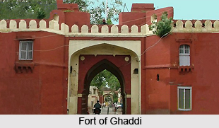
Medieval History of Dahod District : The Mughal emperor Shah Jahan was appointed as the `subedar` or Governor of Gujarat during the regime of Jahangir. Shah Jahan`s wife Mumtaz Mahal is believed to have given birth to Aurangzeb in November 1618, inside the fort of Dahod, known as Fort of Ghaddi. Historical accounts have stated that Aurangzeb had later ordered his royal ministers to grant several imperial favours to Dohad District as this was the very place of his birth.
Modern History of Dohad District : During the year 1857, a famous freedom fighter named Tantia Tope had arrived in Dohad during the Sepoy Mutiny. Under the British Raj in the country, a `dharma shala` or sleeping facility located in this district, created under the rule of Aurangzeb had been transformed into a `gadhi` or tiny fort. When Tantia Tope had camped in the area of Nani Kharaj, this gadhi was attacked by him. He had fought against only a single soldier who was entrusted the responsibility of protecting the fort from Tantia Tope. However, Tope was unsuccessful in his ventures since Colonel Iswat immediately initiated a counter attack on Dahod upon learning about the incident. Consequently, Tantia Tope was compelled to retreat and flee to Banswara and Limli-Jhalod and continued to reside in this region till the last says of his life. Dahod was captured by the British soon after Tope made attempts to do so, during 1857. The beautiful location of Dahod, in the midst of royal states made it appealing in the eyes of the British. This area was leased from the Sindhias, by the British for as many as seven years. Finally, in the year 1890, Dahod was acquired by the British. Dahod was attained after the British had exchanged it for another Indian district.
Education in Dahod District
Dahod district has total 1,689 primary, secondary and higher secondary schools (including government and private). Government Engineering College at Dahod offer courses in chemical, civil, electrical, and electronic and communication, information technology, production and mechanical engineering. Government Polytechnic College at Dahod offer courses in computer, electrical, mechanical and civil engineering. The Industrial Training Institutes (ITIs) in the district offer specialised courses such as welding, software programming, electronic system maintenance, mechanics, instrumentation, cutting and sewing to provide trained manpower for the industries.
Economy of Dahod District
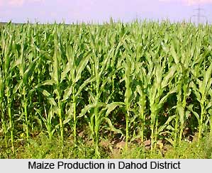 Economy of Dahod District in Gujarat is chiefly dependent on agriculture-based products. Agriculture is the backbone of the financial system of the district. Wheat and maize are the most important crops of the district. Agriculture has given a great momentum to home-based industries such as making jute ropes and weaving bamboo. Industries also help to toughen the economy of the region. 4,000 Metric Tonnes (MT) of quartz is produced in the district and supports cement, glass and ceramic industries. The talukas Dahod and Devgadh Baria houses maximum number of small scale industries. Gujarat Fluoro Chemicals Limited in Goghamba taluka is a public sector unit which is known for refrigerants. Makharia Netting Private Limited in Dahod manufactures fishing net.
Dahod district is a main producer of cereal, maize and vegetable in the state. There are 2,221 units of small scale industries in Dahod which provides employment to more or less 5,000 persons. Most important SSIs in the district are in the sectors such as rubber and plastic products, engineering, readymade garments, food products, minerals etc. Dahod and Devgarh Baria talukas have maximum industrial units in the district i.e. 875 and 541 units respectively. The economy is for the most part driven by agriculture and agriculture based products. Water conservation measures, enhanced agricultural methods and community forestry programs support the agricultural practices in Dahod. Being the district headquarter, Dahod taluka has the highest industrial locations and major section of working population in Dahod are employed in small scale industries. The economy of Dahod also prospers on the grain and pulse mills, food processing machinery, and cement and gypsum industries. The district is well connected to other States through rail and road network which favours the economic prosperity of the district. Tourism to this district is also an important revenue earner. The tribal culture and the enthralling tribal folklores of the district are of immense attraction for the Tourists.
Tourism in Dahod District
 Tourism in Dahod district, Gujarat, offers an exquisite experience to the visitors with its plethora of magnificent temples and places exhibiting the beauty of nature. Many of the temples have ancient origin and are adorned with impressive sculptures and striking architecture. Various myths associated with the temples further make them popular among the tourists as well as devotees. The mesmerizing landscapes of Dahod district also make the place inviting.
Devzari Mahadev Temple : Devzari Mahadev temple is located at the outskirts of National Highway in the district of Dahod at a village called Rozam. It is situated at a distance of about 14 kilometres from the district. In this ancient temple, Shivaratri is celebrated every Monday with great religious fervour.
 Dhudhar Dev Shiva Temple : Dhudhar Dev Shiva Temple stands in the Chakaliya town of Dahod district. The temple houses magnificent idols of Lord Shiva and Lord Hanuman carved in stone. There is also a basin located near the temple.
Kedarnath Temple : Kedarnath temple is situated in Chosala town of Dahod district where Devkedareshvar Mahadeva or the idol of Lord Shiva is the presiding deity. This divine temple has been built in a long stone cave. At the mouth of the temple, a consistent stream of water can be witnessed.
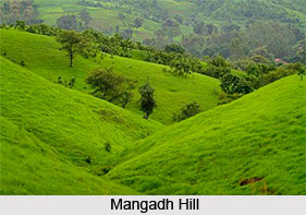
Mangadh Hill : Mangadh hill is located at Taluka Fatepure of Dahod district, in a village named Gadhada. It is considered very scared for the tribal population of Gujarat, Madhya Pradesh and Rajasthan. The place is exquisitely adorned with majestic hills and patches of lush green forests. Backwaters of Kadana dam can be seen very near to Mangadh hill.
Panchkrishna Temple : Panchkrishna temple stands at Zalod taluka of the district, in a village called Therka. This old temple dates back to 12th century. Indian Mythology says that the temple was founded by Pandavas who stayed here for sometime during their forest dwelling.
Ratanpur : Ratanpur is a well known bear sanctuary situated in Dhanpur of Dahod district. It spans an area of about 55 square kilometres and has been declared as a protected area. The sanctuary is famed for its rich variety of flora and fauna.
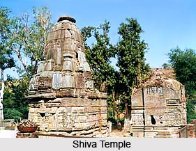
Bavka Temple : Bavka temple, a medieval temple of Lord Shiva is situated in the interior of Dahod District. Bavka temple has been restored by the Archaeological Survey of India (ASI). The origin of this temple has been found to have enrooted in 12th century. Local myths say that it was built in a single night by a Devadasi dancer. It is embellished with unique and exquisite sculptures and architectural beauty for which it has also been notified as a historical pilgrimage spot. The beauty of the temple is augmented by a beautiful tank situated nearby.
Other Tourist Places in Dahod District : In addition to these, other tourist places in Dahod district include Jhalod tower in Vadbazar area, Jalaimata and Hanuman temples and Ramsagar Lake.


