Home > Travel > States of India > Likabali
Likabali
Likabali is the district headquarters of West Siang District of Arunachal Pradesh. It is also the entry point to Arunachal Pradesh from Silapathar in Dhemaji District of Assam.

Share this Article:

Likabali, West Siang District, Arunachal PradeshLikabali is the district headquarters of the West Siang District in the state of Arunachal Pradesh. About 160 km from Itanagar, Likabali is the most well known and important archaeological site of the state. It is also the entry point to Arunachal Pradesh from Silapathar in Dhemaji District of Assam. This hilly area is surrounded by tall trees, which gives a scenic view to its tourists. Malinithan is the most popular tourist spot of Likabali.

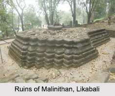
Malinithan in Likabali
Malinithan is a well known tourist spot of this region, which is an archaeological site with temple ruins and sculptural relics. Some of the ruins are also associated with the legends of Lord Krishna. According to Hindu mythology, Lord Krishna and his wife Rukmini, on their way to Dwarka from Bhismaknagar, rested in Malinithan and made offerings of flowers to the Goddess Parvati. The relics in Malinithan were excavated from 1968 to 1971. The temple ruins in this site are seemed to have been built out of granite stones and have Aryan influence on them..

Akashiganga Temple near Likabali
It is one of the famous Hindu pilgrimage sites in Arunachal Pradesh. Akashiganga temple is located near Likabali (12 km from Malinithan). According to the Hindu mythology, one of the body parts of Sati fell in this location. Since then, this temple is regarded as an important holy destination for Shakti worship.

Visiting Information to Likabali
Silapathar Railway Station and Dibrugarh Airport are the nearest to reach Likabali. National Highway 34 connects this city to other parts of India. This article is a stub. You can enrich by adding more information to it. Send your Write Up to [email protected].


Share this Article:

Related Articles

More Articles in States of India


East Indian States
East Indian States comprises of Bihar, Jharkhand, West Bengal, Odisha and also the Union Territory of Andaman and Nicobar Islands. It defines the cultural heritage, rich historical background and the linguistic unity.
Erode District
Erode District is one of the districts in the state of Tamil Nadu. The district of Erode is having a land-locked area with no sea coast.
Purnia District in Bihar
Purnia District is located in Bihar and extends from River Ganga to Nepal. The district has a rich Hindu history and glorious past.
South Delhi District
South Delhi District is the third largest district of Delhi as far as its area is concerned. South Delhi District is known for its economic, historical, cultural and social significance.
North Indian States
North Indian States formed the cultural and religious unity in spite of having many foreign invasion and the political disturbances from the early era till the British gained supremacy in Indian sub continent.
Kendujhar District
Kendujhar District, spread over an area of 8,240 sq kms, is as varied as the whole of Orissa with waterfalls roaring gorges, mountains and minerals. The manifold expressions of nature in Kendujhar District are considered as unique.
Hooghly district
Hooghly District along the bank of the river Hooghly is one of the principal trading ports of West Bengal.
Districts of South Tamil Nadu
Districts of South Tamil Nadu consist of many tourism destinations like archaeological sites and the history of Pandyas and Cholas. Considering their proximity to the sea, many districts also boast of serene beaches and coastal beauty.
Flora of Arunachal Pradesh
Flora of Arunachal Pradesh includes infinite species and is a subject of great interests for the botanists.
Districts of South Gujarat
Districts of South Gujarat are the epicenter of Jain pilgrimages and the early Hindu kingdoms.
North West States of India
North West States of India consist of three states, which are Rajasthan, Punjab and Haryana. All of them are culturally and traditionally diverse and they have been ruled by different dynasties in historical time.
Geography Of Chittoor District
Geography of Chittoor district is spread along the topography of the land which is divided into two natural divisions; Chittoor has a dry and healthy climate.
Districts of North Rajasthan
District of Northern part of Rajasthan is dotted with ancient forts and medieval villages.
Districts of North Odisha
District of North Odisha has Bengal boundary and shares the same culture. These are reachable if one pays a weekend visit to Digha.
Districts of West Bihar
Districts of West Bihar is comprised of medieval monuments that were built by the different governors of Mughal era.
Districts of South Haryana
Districts of South Haryana consists of many cities of industrial excellence. These districts are dotted with popular tourism destinations.
Medieval History of Assam
Medieval history of Assam narrates the advent and rule of a number of kingdoms in the region. The prominent dynasties of the kingdom left an everlasting imprint on the socio cultural heritage of India.
Geography of Meghalaya
The suitable climate, highland plateaus, rivers and the flora and fauna together forms the geography of Meghalaya.
Districts of Rayalaseema
Districts of Rayalaseema in Andhra Pradesh state has urban population and rural settlements as well.
Districts of South Punjab
Districts of Southern part of Punjab depict medieval history of Punjab and the rise of Sikhs.