Home > Indian History > Geography of India > Ghasura Park
Ghasura Park
Ghasura Park is a park designed on the lines of a contemporary Japanese Zen garden at Ampati, Meghalaya.

Share this Article:

Ghasura Park, Garo Hills, Meghalaya
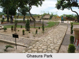
Ghasura Park is located near Ampati town on the banks of the Daru River in the South-West Garo Hills of Meghalaya. The park is ideal for a day"s recreation where there is an open sit out overlooking the Daru River, a pond and a rock garden with a waterfall. The park is beautifully laid out with flowerbeds, shrubs and trees. The setting of the park emits an atmosphere of tranquility and serenity.

Etymology of Ghasura Park
Ghasura Park was named after Ghasui Bhoia, a name with significance of Bhoia "The Mighty one", a man who took this region and its people into modern civilization a century ago. The park is based on a Japanese Zen garden theme.

Project of Ghasura Park
The project of Ghasura Park was initiated by the Department of Tourism, Meghalaya in 2012. The park was formally inaugurated by Dr. Mukul Sangma, Chief Minister of Meghalaya in 2012.

Amenities of Ghasura Park
The entrance of Ghasura Park is at the east of the garden which is lined with silver pine barriers. Towards the south of the park, along a flagstone is a rock garden with date palm, natural Bonsai which are arranged with rocks, pebbles and sand. In the south-western part of the garden, there is a Gazebo overlooking the Daru River. In the west, there is a waterfall and in front of it is an open air amphitheatre. There is also a wooden bridge that crosses a small pool with crystal clear waters.

Ghasura Park is covered with the tropical evergreen offering tranquility and serenity to visitors. The presence of a large number of plants and trees attract numerous birds like the robins, doves, mynas, kingfishers and many others. The park is line with a variety of both indigenous and exotic varieties of flora that can mesmerise visitors to the park.

This article is a stub. You can enrich by adding more information to it. Send your Write Up to content@indianetzone.com.


Share this Article:

Related Articles

More Articles in Geography of India


Geography of Uttar Pradesh
The fourth largest State in India UP is located in the Northern part of India whose area is 2,36,286 sq Kms.
Geography of Maharashtra
Covering an area of 308,000 sq. km, Maharashtra, the third largest state in India.
Geography of Kerala
Geography of Kerala includes plains, hills, valleys and coasts. With the Arabian Sea in the west, the Western Ghats in the east and networked by several rivers, Kerala enjoys diverse geographical features.
Geography of West Bengal
The geography of West Bengal is unique with high peaks of the Himalayan range in the north, the Bay of Bengal in the south and the remaining region is covered with both plains and plateaus.
Geography of Jharkhand
Geography of Jharkhand is comprised of the rich mineral resources and the highly agricultural prospect in this state.
Geography of Sikkim
Geography of Sikkim is characterised by a vast array of magnificent hillock that extends from one corner of the state to the other.
Geography of Meghalaya
The suitable climate, highland plateaus, rivers and the flora and fauna together forms the geography of Meghalaya.
Geography of Mizoram
Mizoram is surrounded by hills, valleys, rivers, waterfalls and lakes. The hills range from 1000 meters to 2000 meters. Rivers, lakes and waterfalls also play major role in forming the land of Mizoram.
Geography of Jammu & Kashmir
Jammu and Kashmir is encompassed by valleys. Some of the dominant valleys of the state are Kashmir Valley, Tawi Valley, Chenab Valley, Poonch Valley, Sind Valley and Lidder Valley etc. Jhelum River is the only major Himalayan River which flows through the Kashmir valley. Indus, Tawi, Ravi and Chenab Rivers are the major ones flowing through the region.
Geography of Daman and Diu
Daman and Diu is situated on the west coast of India and are the smallest union territories of India.
Geography of Goa
Geography of Goa occupies a prime location along the Konkan coastal belt on the western coast of India. The state is bordered by Maharashtra in the north and Karnataka in the south. The Western Ghats in the east contribute to the flora and fauna of Goa.
Geography of Arunachal Pradesh
Geography of Arunachal Pradesh reveals that it is a hilly tract nestled in the foot of Himalayas.
Geography of Kutch
Geography of Kutch District is covering an area of 45,612 km. Kutch District is the largest district in the state of Gujarat.
Geography of Ladakh
Geography of Ladakh mainly comprises the huge Karakoram Range with long stretch of cold desert which mark the region separately from the rest of the states of Indian subcontinent. Surrounded with the mountain ranges from all corners this small region separates Indian subcontinent from rest of the Asian continent.
Geography of Rajasthan
Geography of Rajasthan defines the dry topography with arid climate of the western mountain region.
Geography of Tamil Nadu
The Indian state of Tamil Nadu is located in the Northern hemisphere in the hot zone.