Home > Travel > States of India > Sind Valley
Sind Valley
Sindh Valley is a valley in a mountain range of Srinagar in Jammu and Kashmir.

Share this Article:

Sind Valley, Jammu and KashmirSind Valley is a Himalayan sub-valley of the Kashmir Valley in the State of Jammu and Kashmir of India. The entrance of the Sind Valley lies 33 kilometres (21 mi) northeast of Srinagar the capital of Jammu and Kashmir. The valley begins in Ganderbal and ends near Baltal and the start of the Zojila Pass. Sindh Valley is the main route between Kashmir and Central Asia.

History of Sind Valley
Sind Valley was the one of the major bridges in the past which connected India to China and other central parts of Asia. First Hinduism and Buddhism and then Islam spread in Kashmir through this route.

Location of Sind Valley
Sind Valley is situated in the Ganderbal district of Jammu and Kashmir. It is bordered by the Kashmir Valley in the west, Zojila Pass in the east, Kishanganga in the north and the Lidder Valley in the south. The Sind Valley connects Ladakh with the rest of India through a National Highway NH 1D, though it remains closed during winter due to heavy snowfall at Zojila.

Geography of Sind Valley
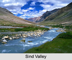
Sind Valley is formed by the flow of the Sind River; it extends up to 65 km in length and 1 km in width which flows down from east to west. The river originates from the inner Himalayas at Drass in Machoi Glacier and runs through green forests of pine and fir and alpine meadows of Sonmarg. The Sind Valley contributes heavily to the economy of the State, through generation of hydroelectricity, provides fresh water supply to other districts and irrigation for agriculture. The Sind River flows through the entire valley passing several natural landmarks. The main towns in the valley are Gund, Mammer, Kangan, Wangath, Preng, Wussan and Manigam.

Geology of Sind Valley
Sind Valley has formed over a period of several thousand years as the Sind River cuts into the Himalayan Mountains. The glaciers of the valley are shrinking. Today, the river continues to deposit the sheets of sand in the lower areas of Ganderbal. Gradual erosive processes have washed away side forests and created a deep gorge at many places.

Ecology of Sind Valley
Sind Valley has many glacier fed streams and is home to different types of trout. As the region is rich in dense vegetation, it is inhabited by several species of animals and plants. The valley is the natural habitat of Himalayan black bear, the Himalayan brown bear, musk deer, snow leopard and hangul. Markhor and ibex are also spotted in Sonmarg of the Sind Valley.

Visiting Information of Sind Valley
The nearest airport from Sind Valley is in Srinagar at a distance of around 35 km. Srinagar railway station is the nearest railhead. One can hire a cab to Sind Valley from both airport and railway station. During the summer season, Sind Valley can be easily accessed by road.


Share this Article:

Related Articles

More Articles in States of India


East Indian States
East Indian States comprises of Bihar, Jharkhand, West Bengal, Odisha and also the Union Territory of Andaman and Nicobar Islands. It defines the cultural heritage, rich historical background and the linguistic unity.
Erode District
Erode District is one of the districts in the state of Tamil Nadu. The district of Erode is having a land-locked area with no sea coast.
Purnia District in Bihar
Purnia District is located in Bihar and extends from River Ganga to Nepal. The district has a rich Hindu history and glorious past.
South Delhi District
South Delhi District is the third largest district of Delhi as far as its area is concerned. South Delhi District is known for its economic, historical, cultural and social significance.
North Indian States
North Indian States formed the cultural and religious unity in spite of having many foreign invasion and the political disturbances from the early era till the British gained supremacy in Indian sub continent.
Kendujhar District
Kendujhar District, spread over an area of 8,240 sq kms, is as varied as the whole of Orissa with waterfalls roaring gorges, mountains and minerals. The manifold expressions of nature in Kendujhar District are considered as unique.
Hooghly district
Hooghly District along the bank of the river Hooghly is one of the principal trading ports of West Bengal.
Districts of South Tamil Nadu
Districts of South Tamil Nadu consist of many tourism destinations like archaeological sites and the history of Pandyas and Cholas. Considering their proximity to the sea, many districts also boast of serene beaches and coastal beauty.
Flora of Arunachal Pradesh
Flora of Arunachal Pradesh includes infinite species and is a subject of great interests for the botanists.
Districts of South Gujarat
Districts of South Gujarat are the epicenter of Jain pilgrimages and the early Hindu kingdoms.
North West States of India
North West States of India consist of three states, which are Rajasthan, Punjab and Haryana. All of them are culturally and traditionally diverse and they have been ruled by different dynasties in historical time.
Geography Of Chittoor District
Geography of Chittoor district is spread along the topography of the land which is divided into two natural divisions; Chittoor has a dry and healthy climate.
Districts of North Rajasthan
District of Northern part of Rajasthan is dotted with ancient forts and medieval villages.
Districts of North Odisha
District of North Odisha has Bengal boundary and shares the same culture. These are reachable if one pays a weekend visit to Digha.
Districts of West Bihar
Districts of West Bihar is comprised of medieval monuments that were built by the different governors of Mughal era.
Districts of South Haryana
Districts of South Haryana consists of many cities of industrial excellence. These districts are dotted with popular tourism destinations.
Medieval History of Assam
Medieval history of Assam narrates the advent and rule of a number of kingdoms in the region. The prominent dynasties of the kingdom left an everlasting imprint on the socio cultural heritage of India.
Geography of Meghalaya
The suitable climate, highland plateaus, rivers and the flora and fauna together forms the geography of Meghalaya.
Districts of Rayalaseema
Districts of Rayalaseema in Andhra Pradesh state has urban population and rural settlements as well.
Districts of South Punjab
Districts of Southern part of Punjab depict medieval history of Punjab and the rise of Sikhs.