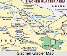
 Situated at an elevation of 5, 589 m, the Sia La Pass is a mountain pass on the Saltoro Ridge, which is immediately north- west of the upper part of the vast Siachen Glacier. The Sia La Pass is a part of the Eastern Karakoram Range and sits near the China border which connects the Siachen Glacier to the Pakistani-controlled Kondus Glacier and valley to the west.
Geopolitical Issues on Sia La Pass
The Sia La Pass is located about 60 km north-northwest of map point NJ9842 which defined the end of the 1972 Line of Control between India and Pakistan as part of the Simla Agreement. In the year 1984, the Sia La Pass along with the nearby passes of Bilafond La and Gyong La witnessed the military controlled action called Operation Meghdoot, which was the first military action of the Siachen conflict and was in itself a part of a much larger dispute, the Kashmir conflict. All 3 passes are currently held by India; Pakistan controls areas just to the west.
This article is a stub. You can enrich by adding more information to it. Send your Write Up to content@indianetzone.com


