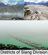
 Districts of Siang Division in Arunachal Pradesh include West Siang District, East Siang district, Siang District and Upper Siang District.
West Siang District
West Siang District is an administrative district in the state of Arunachal Pradesh in India. West Siang District is rich in wildlife. The rare mammals such as Mishmi takin, Snow leopard, Red panda and Musk deer occurs while among birds there is the rare Blyth`s Tragopan.
East Siang District
East Siang District is an administrative district in the state of Arunachal Pradesh. There are 5 Arunachal Pradesh Legislative Assembly constituencies located in this district. These are Panging, Nari-Koyu, Pasighat West, Pasighat East, and Mebo. All of these are parts of Arunachal East Lok Sabha constituency.
Siang District
Siang District is the 20th newly created district of Arunachal Pradesh. Adi tribe of Arunachal Pradesh predominantly inhabits it. This new district was created by bifurcating West Siang and East Siang districts of Arunachal Pradesh consisting of 32-Rumgong-Kaying and 35-Boleng-Pangin Constituencies.
Upper Siang District
Upper Siang District is an administrative district in the state of Arunachal Pradesh in India. It is the fourth least populous district in the country. Upper Siang District is a mountainous region of Himalayan Mountain Range endowed with rich natural resources and biodiversity areas. There are deep gorges and fast flowing streams and rivulets, which form the tributaries of the mighty Siang River. Siang River flows through Upper Siang District running into India at a point near Gelling in the Indo-China border. The four main groups of tribes like Adi Tribe, Memba Tribe, Khamba tribe and Mishmi Tribe, inhabit Upper Siang District. Though they have distinctive socio-cultural life, they have co-existed with each other from the time immemorial along with the Indian culture and tradition. The Adis and Mishmis are animists who are believers of the Sun and the Moon, while the Membas and Khambas are Mahayana Buddhists. Gelling is the last area of Indian boundary, which is attached to the International Boundary of China. The famous MacMohan Line touches this circle. It is about 34 kilometers from Tuting. Riutala is a hill which is interspersed by many snow fed lakes of Lower Himalayan Mountain range. From this river Sipit, Yammeng, Simong Patang and Tangam Patang have originated.


