Introduction
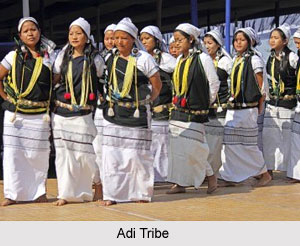
 Upper Siang district is an administrative district of Arunachal Pradesh. The district is a treasure house of natural beauty. It has 11 Administrative Circles. The district has a prominent inhabitation of Idu Mishmi, Khamba, Memba and Aditribes who dwell in this region since time immemorial. However, people of Adi tribe visibly dominate the district and they follow Donyi-Polo religion. People belonging to Memba tribe follow Tibetan Buddhism. The vibrant and colourful rituals and festivals of the district include Dihang, Lossar, Reh, Aran and Solung. The district is also known to be the fourth least populous district of India.
History of Upper Siang District
 History of Upper Siang District is quite ancient and dates back to the period when the north-eastern Indian state of Arunachal Pradesh was an independent area which was devoid of any political control. However, this was only till 1826 to 1861, when the Anglo-Burmese war occurred. The Upper Siang region was declared as a non-regulated area in the time between 1826 to 1861. Arunachal Pradesh continued to be under the administrative control of Bengal until the year 1874, when scheduled district regulation was passed and a separate post of Chief Commissioner was made. This Indian state was able to obtain a distinct identity of its own following its separation from Assam. After its separation, it was renamed as North East Frontier or NEFT after the Government of India, Foreign and Political Department Notification which was passed in the year 1914. Thereafter, the present-day Upper Siang became a portion of NEFT`s Central Section and it controlled Administrative Control of Political Officer.
In the year 1919, the Central Section as well as the Eastern Section of the same piece of land was termed as Sadiya Frontier Tract and its headquarters was present at Sadiya. Sadiya Frontier Tract was divided into two separate regions in the year 1948. These separate regions were named as Mishmi Hills District and Abor Hills District. After India gained independence from the British Raj, Arunachal Pradesh was categorised under Part B of the 6th schedule of the Indian Constitution as a portion of the state of Assam. In the year 1951, this area was marked as North-East Frontier Agency or NEFA. It was classified under NEFA (Administration) Regulation in the year 1954 was declared as a part of Assam during the period 1950 to 1965. Abor Hills District was later renamed as Siang Frontier Division.
The Siang Frontier Division was decided to be renamed as Siang District in the year 1965. During this time, the NEFA administration was shifted to the Ministry of Home Affairs. The Political Officer of Siang district was given the designation of Deputy Commissioner. During the year 1967, the NEFA Panchayati Raj Regulation Act was passed by the Government of India. According to this act, the status of Gram Panchayat was accorded to the Traditional Village Councils, armed with the Agency Council at the Apex Level of the Panchayati Raj. On 20th January, 1972 the NEFA became a Union Territory by the name of Arunachal Pradesh. Pradesh Council replaced the Agency Council and later it was transformed into Legislative Assembly in the year 1975. During 1978, the first Election to 30 members Legislative Assembly was held.
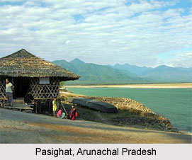
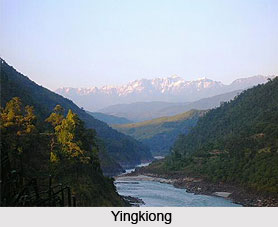
Siang district was divided into West Siang district and East Siang district in the year 1980. The current-day Upper Siang region continued to be under the jurisdiction of East Siang district. Pasighat was the place where its headquarters was located. On 20th February, 1987, the Union Territory was given the status of a permanent statehood. The number of members belonging to the Members of Legislative Assembly increased from 30 to 60. Eventually, Upper Siang district was born from the East Siang district in the year 1994, while its headquarters were based at Yingkiong.
Geography of Upper Siang District
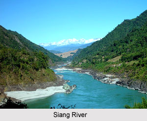
Upper Siang district is situated in the lap of nature with ravishing mountains having a variety of natural resources and a great biodiversity. Streams and rivulets meander gracefully through the place and form the tributaries of Siang River. Deep and wondrous gorges also adorn this beautiful district. It has a geographical area of 6188 square kilometres.
Demography of Upper Siang District
 As per the census of 2011, the district has a population of 35,289 and ranks 637th in the country. The population density of the district is 5 persons per square kilometre. The population growth of the district has been recorded to be 5.77 percent. Sex ratio is 891 females per 1000 males. Upper Siang district has a literacy rate of 59.94 percent. Adi, which is a Sino-Tibetan dialect is the common language of the district and include about 140 000 speakers. It is written in both Latin and Tibetan.
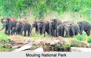
Upper Siang district houses the famous Mouling National Park with an area of 483 square kilometres. Development of Upper Siang district has undergone major improvements. This seclusion and inaccessibility of the district have been the focus of the socio-economic developments and efforts have been made to improve the same. The headquarters of the district is situated at Yingkiong.
Tourism in Upper Siang District
 Tourism in Upper Siang district is known for its exquisite natural beauty. High snow capped mountains, diverse vegetation and graceful rivers paints a picturesque landscape of the district. A number of rare and endangered species of fauna and birds are also the inhabitant of this district which makes it an ideal destination for nature lovers. Trekking and mountaineering are also cherished activities for the tourists in Upper Siang district. The vibrant culture of the district forms another point of attraction. Tourist from different parts of the country also visit this place to explore the unique yet enticing lifestyle, customs and rituals of the dwellers of Upper Siang District.
Mariyang (Pekimodi Circuit) : Mariyang is located at about 52 kilometres away from the district headquarters, Yingkiong. The place is mainly inhabited by Millang, Pasi and Padam communities. It is located at a hillock and offers a panoramic view of the confluence of Yamne and Yammeng rivers. The place has a mesmerizing scenic beauty. Damro village near Mariyang is the largest village of the district. Pekimodi is also inhabited by the people of Adi tribe. Solung is a prominent festival of this place which is accompanied by a traditional dance known as Ponung. Other tourist attractions of Mariyang include angling and trekking.
Tuting (Gelling Circuit) : The last Circle headquarters of the district is Gelling and is attached with the International Boundary of China. The Mac Mohan Line also touches the Circle. At this place, river Tsangpo enters the district from Tibet and is locally called as Tsang Chu. This river is known as Bramhaputra in Assam and Siang River in the South. The Gelling Circuit is inhabited by Memba tribe which is a Nyingma Sect of Mahayana Buddhist. The important festivals of this community are Tsobum Community, Dhruba Community, Torgya Community and Lossar Community which are celebrated according to the Buddhist Calendar. The most enchanting feature of these festivals is the mask dance, also known as Bardoh Chaam, which are performed by Gonpas. Mask of animals are worn by the dancers and the central theme remains the victory of good over the evil. They also focus on the preservation of all forms of life. Remnants of Kapangla Pass and beautiful waterfalls are also enlisted in the major attractions of the place.
Yingkiong - Ekodumbing (Riutala Circuit) : Ekodumbing falls under Simong territory. Groups of people belonging to this territory arrive at this place in the months of October and November for collecting aconite used for hunting. Rare species of fauna including Musk deer and Takins as well as birds like Siko, Tane and Pede dwell in this place. The place is also home to a variety of medicinal plants. Lately the place has acquired religious significance for Buddhists. Ekodumbing is regarded as a paradise of Awalokeshwara by them. A number of Buddhist pilgrims visit this place for offering prayers. Riutala is a famous hill of this place which is surrounded by several lakes. Sipiti River flows in this district from which Tangam Patang, Simong Patang and Yammeng have originated. Ekodumbing has a breathtaking beauty with a number of caves which provides shelter to the pilgrims.
Yingkiong - Tuting (Dewakota Circuit) : Dewakota is a Sanskrit word which implies `abode of God`. Nyigong River surrounds the place which is located on a plateau. The natives of the region believe that the place houses many sacred treasures kept by Guru Rimpoche which are yet to be explored. A number of holy spots dot this place like Guru Durpuk, Sindura and several caves. These caves serves as an accommodation of the pilgrims in winter season while in summers they remain submerged under Yangshang Chu River. It is a belief that the person visiting Dewakota thrice becomes free form all the past sins and attains heaven.
Yingkiong - Tuting (Tsitapuri Circuit) : Tsitapuri is also a pilgrimage centre which falls under Yingkiong - Tuting Circuit of Singha Circle. The place is considered as the paradise of Lord Guru Rimpoche. More than 108 lakes are present here among which Lake Danakhosa is a famous one. It is also the origin of rivers Nyigong and Jeying Chu. Barren mountains valleys surround the lake and are covered with snow throughout the year.
Mouling National Park : Mouling National Park is situated in the right bank of river Siang. It was established in the year 1982 with an aim of creating a favourable habitat for a variety of flora and fauna. The flora of this region differs greatly with differing altitude. At higher altitude, temperate alpine and coniferous forests are found whereas in the lower region tropical evergreen forest is found. The place is full of plants like orchids and foxtail. Mouling National Park has also an abundance of endangered species of animals and birds including hornbill, snowclouded leopard, takins, monal scalater and many more. There are many species which are yet to be recognized. Several enchanting waterfalls are also found here including Nirbung waterfall and Dabung waterfall. Mouling National Park serves as a paradise for trekkers and wildlife lovers.