 Bay of Bengal comprises of the northeastern part of the Indian Ocean. It has maximum length of about 2,090 km, maximum width of about 1,610 km, surface area of about 2,172,000 square kilometers and average depth of about 2,600 m. This water body contributes to the economy of India by serving as a trade route, housing seaports and having a number of beaches. Bay of Bengal also has islands, which have lent beauty to it.
Andaman and Nicobar Islands
Andaman and Nicobar Islands is one of the seven union territories of India. This island comprising an area of about 8,249 square kilometers is further divided into several other islands. Some of them are mentioned below.
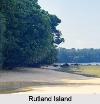
Rutland Island
Rutland Island belongs to the South Andaman administrative district. This island spreads over an area of about 121.5 square kilometers. It has a length of about 18 km, width of about 11 km and coastline of about 69 km. This island is utilized for training open water divers. Jahaji Beach, Bada Balu, Manner Strait, Photo Nallah and Dani Nallah are places of tourist interest on this island.
North Sentinel Island
 North Sentinel Island is a part of the Andaman Islands in the Bay of Bengal. It occupies an area of about 47.5 square kilometers. It has a length of about 7.8 km, width of about 7.0 km and coastline of about 31.6 km. The North Sentinel Island is forested, except the reefs.
Katchal Island
Katchal Island is one of the Nicobar Islands in the Bay of Bengal. It occupies an area of about 146.5 square kilometers. The geographical terrain of this island is characterized by hills of calcareous sandstone and marble slates, forest with a plethora of pythons, black monkeys, pigs and beaches.
Teressa Island
Teressa Island is a part of the Nicobar Islands in the Bay of Bengal. This island is spread over an area of about 86.5 square kilometers and has a coastline of about 52.8 km in length. According to the Indian National Census of 2011, this island had a population of about 1,934.
Other Andaman and Nicobar Islands
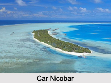
Trinket Island, Barren Island, Little Andaman, Car Nicobar are some of the Other Andaman and Nicobar Islands.
Sriharikota
Sriharikota Island is located in Nellore district in the state of Andhra Pradesh, off the Bay of Bengal coast. This barrier island is utilized by the Indian Space Research Organization to launch satellites using multistage rockets such as the Polar Satellite Launch Vehicle and the Geosynchronous Satellite Launch Vehicle. Satish Dhawan Space Centre is also located on this island.


