 The state of Mizoram, also known as the "land of the hill people" is located in the north eastern part of India. The geographical terrain of this state is characterized rolling hills, valleys, rivers like Chhimtuipui and lakes like Palak Lake and Tam Dil Lake. The natural beauty of Mizoram, along with its flora and fauna and pleasant climate draw tourists to this state. To reach Mizoram, a domestic airport called Lengpui Airport has been established in the state.
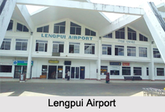
Lengpui Airport
Lengpui Airport is situated in Aizawl. This public airport is owned by the Government of India and operated by Airports Authority of India and the Indian Government. This domestic airport has a runway of about 2,500 meters in length. It is well equipped with a Cat-I instrument landing system. The aviation fuel service department of Lengpui Airport is handled by the Indian Oil.
This article is a stub. You can enrich by adding more information to it. Send your Write Up to content@indianetzone.com


