Home > Indian History > Geography of India > Gopi Talav, Surat, Gujarat
Gopi Talav, Surat, Gujarat
Gopi Talav is a well maintained lake in Surat of Gujarat. It is now an eco tourism spot in Gujarat.

Share this Article:

Gopi Talav, Surat, Gujarat
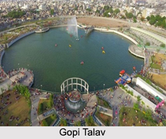
Gopi Talav is a lake in the Gopipura locality in the city of Surat in Gujarat. Gopi Talav is well maintained by the Municipality of Surat. In 2012, Gopi Talav and the surrounding areas were renovated. The Government of Gujarat and the Surat Municipality undertook it as an eco tourism spot. Many species of fishes and birds are found here thus contributing to a great atmosphere for photography.

History of Gopi Talav
Gopi Talav was built in 1510 CE by Malik Gopi, who was an affluent merchant and Governor of Surat during the rule of Mughal Dynasty. Malik Gopi, a Brahmin merchant, settled in Surat and the development of the city has been attributed to his contributions. The area, developed by Malik Gopi was called Gopipura, in his honour and the king of Gujarat gave him the title of "Malik"

Gopi Talav in Indian Literature and History
A noted Sanskrit poet Vinayavijaya (1613-1681) in his poem "Indudutam" calls this lake a "fine art emerged from the churning of oceans". The lake also finds mentions in travelogues of European visitors. British traveller Peter Mundy who arrived in Surat in September 1628 describes the lake as "the Great Tancke of Surat". Dutch geographer Joannes de Laet`s in 1631 mentioned this lake to have been cut out of a rock.

Geography of Modern Gopi Talav
The modern Gopi Talav is stretching around 90,000 square metres (970,000 sq ft) of land was renovated, where the 212 metres (696 ft) diameter lake covered almost 35,000 square metres (380,000 sq ft) of area. The lake can hold 120,000,000 litres of water.

Amenities of Gopi Talav
The redevelopment of Gopi Talav and the park around it is based on the renovation of Kankaria Lake in Ahmedabad. The renovated surroundings include amphitheatre and fountain plaza. The area has been divided into 7 zones:

1. Diamond Zone
2. Food Zone
3. Environment Zone
4. History Zone
5. Communal Harmony Zone
6. Textile Zone
7. Surat Nu Jaman

The Surat Municipal Corporation has outsourced the operation and maintenance of these to a local company called "Rajhans Entertainment" which would develop an amusement park called "Future Zone". Water to the lake was piped from the Tapi River on whose banks the city lies and acts as a major life line of this area.


Share this Article:

Related Articles

More Articles in Geography of India


Geography of Uttar Pradesh
The fourth largest State in India UP is located in the Northern part of India whose area is 2,36,286 sq Kms.
Geography of Maharashtra
Covering an area of 308,000 sq. km, Maharashtra, the third largest state in India.
Geography of Kerala
Geography of Kerala includes plains, hills, valleys and coasts. With the Arabian Sea in the west, the Western Ghats in the east and networked by several rivers, Kerala enjoys diverse geographical features.
Geography of West Bengal
The geography of West Bengal is unique with high peaks of the Himalayan range in the north, the Bay of Bengal in the south and the remaining region is covered with both plains and plateaus.
Geography of Jharkhand
Geography of Jharkhand is comprised of the rich mineral resources and the highly agricultural prospect in this state.
Geography of Sikkim
Geography of Sikkim is characterised by a vast array of magnificent hillock that extends from one corner of the state to the other.
Geography of Meghalaya
The suitable climate, highland plateaus, rivers and the flora and fauna together forms the geography of Meghalaya.
Geography of Mizoram
Mizoram is surrounded by hills, valleys, rivers, waterfalls and lakes. The hills range from 1000 meters to 2000 meters. Rivers, lakes and waterfalls also play major role in forming the land of Mizoram.
Geography of Jammu & Kashmir
Jammu and Kashmir is encompassed by valleys. Some of the dominant valleys of the state are Kashmir Valley, Tawi Valley, Chenab Valley, Poonch Valley, Sind Valley and Lidder Valley etc. Jhelum River is the only major Himalayan River which flows through the Kashmir valley. Indus, Tawi, Ravi and Chenab Rivers are the major ones flowing through the region.
Geography of Daman and Diu
Daman and Diu is situated on the west coast of India and are the smallest union territories of India.
Geography of Goa
Geography of Goa occupies a prime location along the Konkan coastal belt on the western coast of India. The state is bordered by Maharashtra in the north and Karnataka in the south. The Western Ghats in the east contribute to the flora and fauna of Goa.
Geography of Arunachal Pradesh
Geography of Arunachal Pradesh reveals that it is a hilly tract nestled in the foot of Himalayas.
Geography of Kutch
Geography of Kutch District is covering an area of 45,612 km. Kutch District is the largest district in the state of Gujarat.
Geography of Ladakh
Geography of Ladakh mainly comprises the huge Karakoram Range with long stretch of cold desert which mark the region separately from the rest of the states of Indian subcontinent. Surrounded with the mountain ranges from all corners this small region separates Indian subcontinent from rest of the Asian continent.
Geography of Rajasthan
Geography of Rajasthan defines the dry topography with arid climate of the western mountain region.
Geography of Tamil Nadu
The Indian state of Tamil Nadu is located in the Northern hemisphere in the hot zone.