Home > Travel > States of India > Talaguppa
Talaguppa
Talaguppa is the hill station in Karnatka. This village in the hilly area attracts a large number of tourists of both national and international level.

Share this Article:

Talaguppa, KarnatakaTalaguppa is a hilly village located in Sagara Taluk in Karnataka. The National Highway No.206 (Bangalore - Honavar) passes through Talaguppa village. The Mysore State Railway started laying the Shimoga-Talaguppa 1,000 mm line in the year 1930 to provide access to Jog Falls. Jog Falls in one of the prominent tourist spot in Talaguppa and the Sagara region in Karnataka.

Location of Talaguppa
The village of Talaguppa is 14.37 kilometres from the taluk`s centre Sagara, 77.68 km from Shimoga, and 323 km from Bangalore. It is located at a distance of 14 km from Jog Falls, the highest waterfall in India and Talaguppa is the linking Railway terminus for Jog falls.

Climate of Talaguppa
The temperature of Talaguppa is about 24 degree Celsius and the wind blown at about 13 km/h. throughout the year, Talaguppa enjoys good humidity of about 82 percent.

Economy of Talaguppa
The region of Talaguppa has the plantation of Areca nut and paddy, which are the most grown crops.

Culture of Talaguppa
The famous personalities those who born in Talaguppa are Nalvadi Krishnaraja Wodeyar, Jayachamarajendra Wodeyar, Sir M Visvesvaraya, Lal Bahadur Shastri and Morarji Desai used this line to reach Jog Falls to see the scenic beauty of the nature.

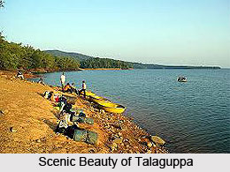
Tourism in Talaguppa
Talaguppaha Temple dedicated to the Hindu Gods and Goddesses like Shree Kadambeshwar temple, Shree Veerabhadreshwar temple and Shree Ranganath temple There is a mosque as well as a church near Travellers Bungalow. The nearby villages are Kanle (5.294 km), Shiravanthe (7.201 km), Syduru (7.446 km), Masuru (11.78 km), Keladi (11.82 km), Sagara city (14.37 km) and Malve (15.26 km).

Visiting Information
Talaguppa is connected by rail from Bengaluru and Shimoga and connecting point to Jog Falls. The Shimoga-Talaguppa railway is a railway line in India connecting the city of Shimoga to the village of Talaguppa in Karnataka. The line passes through the city of Sagara. The metre gauge railway track between the town of Shimoga and Talaguppa was laid by the British in 1938. In 1939, Mirza Ismail took the maiden journey on this line to visit the city of Sagara. This rail link provided access to Jog Falls, which is 12 km from Thalaguppa.


Share this Article:

Related Articles

More Articles in States of India


East Indian States
East Indian States comprises of Bihar, Jharkhand, West Bengal, Odisha and also the Union Territory of Andaman and Nicobar Islands. It defines the cultural heritage, rich historical background and the linguistic unity.
Erode District
Erode District is one of the districts in the state of Tamil Nadu. The district of Erode is having a land-locked area with no sea coast.
Purnia District in Bihar
Purnia District is located in Bihar and extends from River Ganga to Nepal. The district has a rich Hindu history and glorious past.
South Delhi District
South Delhi District is the third largest district of Delhi as far as its area is concerned. South Delhi District is known for its economic, historical, cultural and social significance.
North Indian States
North Indian States formed the cultural and religious unity in spite of having many foreign invasion and the political disturbances from the early era till the British gained supremacy in Indian sub continent.
Kendujhar District
Kendujhar District, spread over an area of 8,240 sq kms, is as varied as the whole of Orissa with waterfalls roaring gorges, mountains and minerals. The manifold expressions of nature in Kendujhar District are considered as unique.
Hooghly district
Hooghly District along the bank of the river Hooghly is one of the principal trading ports of West Bengal.
Districts of South Tamil Nadu
Districts of South Tamil Nadu consist of many tourism destinations like archaeological sites and the history of Pandyas and Cholas. Considering their proximity to the sea, many districts also boast of serene beaches and coastal beauty.
Flora of Arunachal Pradesh
Flora of Arunachal Pradesh includes infinite species and is a subject of great interests for the botanists.
Districts of South Gujarat
Districts of South Gujarat are the epicenter of Jain pilgrimages and the early Hindu kingdoms.
North West States of India
North West States of India consist of three states, which are Rajasthan, Punjab and Haryana. All of them are culturally and traditionally diverse and they have been ruled by different dynasties in historical time.
Geography Of Chittoor District
Geography of Chittoor district is spread along the topography of the land which is divided into two natural divisions; Chittoor has a dry and healthy climate.
Districts of North Rajasthan
District of Northern part of Rajasthan is dotted with ancient forts and medieval villages.
Districts of North Odisha
District of North Odisha has Bengal boundary and shares the same culture. These are reachable if one pays a weekend visit to Digha.
Districts of West Bihar
Districts of West Bihar is comprised of medieval monuments that were built by the different governors of Mughal era.
Districts of South Haryana
Districts of South Haryana consists of many cities of industrial excellence. These districts are dotted with popular tourism destinations.
Medieval History of Assam
Medieval history of Assam narrates the advent and rule of a number of kingdoms in the region. The prominent dynasties of the kingdom left an everlasting imprint on the socio cultural heritage of India.
Geography of Meghalaya
The suitable climate, highland plateaus, rivers and the flora and fauna together forms the geography of Meghalaya.
Districts of Rayalaseema
Districts of Rayalaseema in Andhra Pradesh state has urban population and rural settlements as well.
Districts of South Punjab
Districts of Southern part of Punjab depict medieval history of Punjab and the rise of Sikhs.