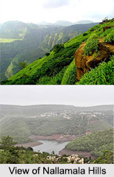
 Nallamala Hills which is also known as Nallamalla Range is the Indian hill station which attracts a large number of tourists throughout the year except in monsoon and the winters. This hill station is enriched with large number of domestic and migratory birds. This section of Eastern Ghats Range is located in the southern portion of India.
History of Nallamala Hills
The mythological history of Nallamala Hill continues to a large extent, since some of the tribes living within Nallamalla have practically refused to take up civil living and are hostile towards a non-tribals or rival tribals, and also because these ranges are largely unexplored and stay unexplored even till date.
Location of Nallamalla Hills
Nallamalas which is also called the Nallamalla Range are a section of the Eastern Ghats Mountain Range which stretches primarily over Kurnool District, Guntur District, Prakasam District, Kadapa District and Chittoor district of the state of Andhra Pradesh and Mahabubnagar District, Nalgonda district of the South Indian state of Telangana. This state is a newly formed state in India with Hyderabad as its capital.
 Climate of Nallamala Hills
Nallamala Hill enjoys warm to hot climate throughout the year. The average rainfall ranges about 90 cm and is concentrated in the months of the South West Monsoon (June to September). The fissured rocks prevent any water from percolating subversive ground and hence most of the discharge runs off as mountain streams to join the Gundlakamma River, which is the largest river to arise in these hills. The winters are mostly cool and dry with the average temperature around 25 degrees Celsius.
Population of Nallamala Hills
Uneven terrain and the scarcity of water have prevented the growth of any large cities in this region. Kurnool is the largest city and Nandyal, located nearer to the forest than Kurnool, is the second largest city of this region. Chenchus is the dominant tribe of this region, the people of which still remain in distant from the modern world. Chenchus are still occupied in hunting and other people with farming.
Mountain Range of Nallamala Hills
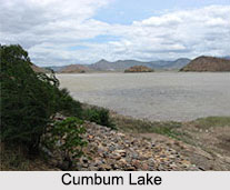
Nallamala Hill is an extremely old system of residual hills. The hills have been extensively weathered and eroded over the years. The average elevation today is about 520 m which reaches 1100 m at Bhairani Konda and 1048 m at Gundla Brahmeswara. Both of these peaks are in a north westerly direction from the town of Cumbum. In the town of Cumbum, there is a lake called Cumbum Lake. Nallamala Hills also have many other peaks above 800 m. Over a period of history joining all the four present states of Telangana, Karnataka, Tamil Nadu and Maharashtra, a legend survives that "Nallamalla" is a treasure trove in the region.
 Rocks of Nallamala Hills
The rocks of the Nallamala ranges belong to the Kadapa system which is a thick series of 20,000 ft. The primary rocks are Quartzite superimposed with an asymmetrical salty formation. Some sandstone is also to be found. The rocks in Nallamala here are very irregular and soft in texture thus rendering commercial exploitation impossible. These rocks are among the oldest in the world and have been formed as a result of large scale volcanic activity hundreds of millions of years ago.
Extension of Nallamala Hills
Nallamalas run in a nearly north-south alignment, parallel to the Coromandel Coast for close to 430 kilometers between the Krishna River and Pennar River. The northern boundaries of Nallamala Hill are marked by the flat Palnadu basin while in the south it merges with the Tirupati hills.
Tourism in Nallamala Hills
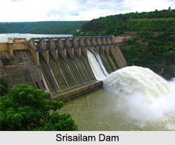
Nallamala Hill houses several tourist spots some of which are Srisailam Hydroelectric power and ancient temple dedicated to Lord Shiva; Mahanandi temple and Ahobilamnava Narsimha Temples; Nemaligundam pool; Mallela Theertham waterfall; Asia"s oldest man made Cumbum Lake etc. Cumbum Lake was built by Gajapati kings of Odisha for irrigation. It was later renovated by queen Vardarajamma of Vijayanagara kingdom in the 16th Century.
Visiting Information to Nallamala Hills
Nallapadu-Nandyal line of the Guntur railway division passes through the hill region. Nearest railway stations are at Chennai and Southern Mahratta Railway. The railway enters the hill at the Nandikama Pass near Cumbum Lake.