 Neil Island, situated in the Andaman Islands of the Indian Union Territory Andaman and Nicobar Islands, hosts serene and deserted beaches which offer invigorating time to the tourists. It is the southernmost island of the Ritchie`s Archipelago and has been named after a British soldier, James George Smith Neill, who had strongly dealt with the insurgents of the 1857 Mutiny. It spans over an area of 18.9 square kilometres. This small island stretches to about 5 kilometres. The hue of sea water varies from light blue, dark blue to green and the beaches of the island reveal a riveting beauty encased in a tranquil ambience. It is also known as the vegetable bowl of Andaman Islands owing to its quantity and quality agricultural produce.
Demography of Neil Island
The population of Neil Island mainly dwell in five villages namely Ram Nagar, Lakshmanpur, Neil Kendra, Bharatpur and Sitapur. Bharathpur hosts the only jetty which serves as the lone point of entry and exit to the island. The villagers primarily depend on agriculture for their livelihood. Neil Island is also popular for supplying vegetables to the rest of the Andaman. It also has a good cattle population and is famed for milk production which is mostly transported to the capital city.
Tourism in Neil Island
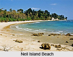
 Neil Island hosts a number of magnificent tourist spots which are worth visiting. Ramnagar beach in the island is a shady beach where the light blue water sparkles beautifully. Colourful corals can be witnessed through the glass bottom boat trips. The coral beds have an abundance of fishes and the crystal clear water provides a good visibility. Snorkelling is greatly enjoyed here. Sitapur beach is another inviting place which offers spellbinding views of sunrise. The beach is ideal for swimming. Lakshmanpur beach is famous for beautiful sunset. The long and serene beach has a pristine beauty.
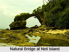
Beach 8 is another prominent tourist attraction of Neil Island which hosts a small cave. Exploring the cave and snorkelling are the main activities enjoyed here. A variety of shells can be found scattered all over the beach. Natural bridge comprises a small strip of land which connects Neil Island with another small island. It is safe to visit only during low tides. Sunset point is located at the western end of the beach where pretty sunsets can be viewed. Diverse fishes, live corals and numerous anemones can be seen at the edges of the shallow reefs.
Visiting Information
Neil Island is located at a distance of 36 kilometres from Port Blair. The place can be reached from the Phoenix Bay jetty at Port Blair in about 2 hours. Scuba diving and snorkelling is greatly enjoyed here by the tourists.


