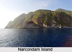
 Narcondam Island, situated in the Andaman Sea, is a part of the Indian union territory of Andaman and Nicobar Islands. It is a small volcanic island formed of andesite with a central peak that rises to a height of 710 metres above the mean sea level. It is in fact included in the Andaman Islands. It encompasses an area of around 6.8 square kilometres. Geological Survey of India has classified it as a dormant volcano. The island derives its name from the Sanskrit word naraka-kundam which refers to a pit of hell. Narcondam Island is the second tallest point in the Andaman and Nicobar Islands.
History of Narcondam Island
Narcondam Island was owned by Burma till the year 1986. The claim of Burma ended after they reached an agreement with India about the delimitation of the maritime boundary between the two countries in the Bay of Bengal, the Coco Channel and the Andaman Sea.
Geography of Narcondam Island
A volcano has resulted in the formation of Narcondam Island. The former was known to be inactive till 8th June 2005 when the ejection of mud and smoke from the volcano was reported. This activity probably owes to the 2004 Indian Ocean earthquake which caused underground movement of magma.
 Narcondam Island lies at a distance of 160 miles from Port Blair and 800 miles away from Visakhapatnam, which is a part of mainland India. It forms the easternmost point of the Andaman and Nicobar Islands.
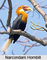
Narcondam Hornbill
Narcondam Hornbill is an endemic bird of this island which is also an endangered hornbill. It is believed that the bird has evolved separately from the Wreathed Hornbill and the latter is an inhabitant of North East India. It is strictly monitored in the forest.
Scuba Diving at Narcondam Island
The waters enclosing the Narcondam Island is greatly cherished for scuba diving. The major diving sites around the island include rocky ridges and steep slopes such as Lighthouse Reef, Ooh La La and Chimneys which are the treasure house of abundant barrel sponges, lush soft corals and huge gorgonian fans. Fishes exhibit a great diversity and enlist species like Gray Reef Sharks, Occasional Whitetip, Mantas, Bumphead Parrotfish, Napoleon Wrasse and others. HQ Pinnacle is another wonderful spot hosting a submerged rock formation which behaves as a magnet for hefty Dogtooth Tuna and numerous Bigeye Trevally. The island offers tranquil ambience at many bays encompassing the island which exhibit gently sloping terrains. Vibrant and colourful reef fishes and wondrous fields of hard corals add to the charm of the places. These bays are safe and protected from current and thus offer a delightful afternoon dive.