Kazhuveli
Kazhuveli is located in Villupuram District of Tamil Nadu is the second largest brackish water lake in South India.

Share this Article:

Kazhuveli, Villupuram District, Tamil Nadu
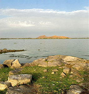
Kazhuveli is located at about 18 kilometres north of Puducherry, which is known as "The French Riviera of the East" (La Cote d`Azur de l`Est). Kazhuveli is the second largest brackish water lake in South India located in Tindivanam taluk of Villupuram district of the state of Tamil Nadu.

Kazhuveli tank lies adjacent to the Bay of Bengal along the East Coast Road and includes about 15 villages with a catchment area of 4,722 hectares of land.

Kazhuveli is an old mangrove forest in Tamil Nadu, which has been degraded over period of time. The entire ecosystem of this wetland is completely destroyed and denuded due to human intrusion, chiefly, the establishment of salt pans and over-fishing.

Kazhuveli is one of the prioritized wetlands of Tamil Nadu. It is also one of the 94 identified wetlands under National Wetland Conservation and Management Programme (NWCMP) operationalised by the Government of India in 1985-86 along with Point Calimere and Pallikaranai Marsh in the state of Tamil Nadu.

A total of 196 minor irrigation tanks and ponds drain into the Kazhuveli wetlands of Villupuram district. Out of the total area of 740 square kilometres, 47.22 square kilometres has been declared as protected area under Section 26 of Tamil Nadu Forest Act. In the northern part of Kazhuveli where brackish water could be found, attempts are made to dig up channels in fish-bone design and mangroves species such as Rhizhophora and avicennia have been planted in extents varying from 50 to 100 hectares annually.

In the southernmost portions of Kazhuveli where seasonal water flow is available, the mangrove plantations have been raised in total barren areas with appropriate species through schemes such as Tamil Nadu Afforestation Project and the National Afforestation Project.

The various conservation projects of the mangrove forests near Kazhuveli tasks such as bio-upgradation, eco-development, community development works, protection, monitoring and evaluation are being implemented and seminars and workshops are being conducted since 2007 under the NWCMP. This also happens for fostering tourism in this region which adds the revenue generation in this region. One can find bird species like spotted owlets in this mangrove region of wetland in Villupuram District of Tamil Nadu.


Share this Article:

Related Articles

More Articles in Geography of India


Geography of Uttar Pradesh
The fourth largest State in India UP is located in the Northern part of India whose area is 2,36,286 sq Kms.
Geography of Maharashtra
Covering an area of 308,000 sq. km, Maharashtra, the third largest state in India.
Geography of Kerala
Geography of Kerala includes plains, hills, valleys and coasts. With the Arabian Sea in the west, the Western Ghats in the east and networked by several rivers, Kerala enjoys diverse geographical features.
Geography of West Bengal
The geography of West Bengal is unique with high peaks of the Himalayan range in the north, the Bay of Bengal in the south and the remaining region is covered with both plains and plateaus.
Geography of Jharkhand
Geography of Jharkhand is comprised of the rich mineral resources and the highly agricultural prospect in this state.
Geography of Sikkim
Geography of Sikkim is characterised by a vast array of magnificent hillock that extends from one corner of the state to the other.
Geography of Meghalaya
The suitable climate, highland plateaus, rivers and the flora and fauna together forms the geography of Meghalaya.
Geography of Mizoram
Mizoram is surrounded by hills, valleys, rivers, waterfalls and lakes. The hills range from 1000 meters to 2000 meters. Rivers, lakes and waterfalls also play major role in forming the land of Mizoram.
Geography of Jammu & Kashmir
Jammu and Kashmir is encompassed by valleys. Some of the dominant valleys of the state are Kashmir Valley, Tawi Valley, Chenab Valley, Poonch Valley, Sind Valley and Lidder Valley etc. Jhelum River is the only major Himalayan River which flows through the Kashmir valley. Indus, Tawi, Ravi and Chenab Rivers are the major ones flowing through the region.
Geography of Daman and Diu
Daman and Diu is situated on the west coast of India and are the smallest union territories of India.
Geography of Goa
Geography of Goa occupies a prime location along the Konkan coastal belt on the western coast of India. The state is bordered by Maharashtra in the north and Karnataka in the south. The Western Ghats in the east contribute to the flora and fauna of Goa.
Geography of Arunachal Pradesh
Geography of Arunachal Pradesh reveals that it is a hilly tract nestled in the foot of Himalayas.
Geography of Kutch
Geography of Kutch District is covering an area of 45,612 km. Kutch District is the largest district in the state of Gujarat.
Geography of Ladakh
Geography of Ladakh mainly comprises the huge Karakoram Range with long stretch of cold desert which mark the region separately from the rest of the states of Indian subcontinent. Surrounded with the mountain ranges from all corners this small region separates Indian subcontinent from rest of the Asian continent.
Geography of Rajasthan
Geography of Rajasthan defines the dry topography with arid climate of the western mountain region.
Geography of Tamil Nadu
The Indian state of Tamil Nadu is located in the Northern hemisphere in the hot zone.