Home > Indian History > Geography of India > North East Indian Coalfields
North East Indian Coalfields
North Eastern coalfields represent the rich sources of coal mines in the Eastern Indian states.

Share this Article:

North East Indian Coalfields
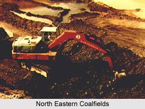
North Eastern coalfields are a sector of an organization known as Coal India Limited, whose headquarters is based in the place called Margherita in the Indian state of Assam. In 1975, this unit was established, following the conversion of the private sector`s coals into public sector, which is referred to as nationalization of these coal mines in the country. The other important coal mines in India are located in the Eastern Indian states of Arunachal Pradesh, Meghalaya and Nagaland. Currently, there are five functioning mines, out of which three are underground and two others are opencast coal mines.

Today, the activities of coal mining are restricted to Makum coalfields in the district of Tinsukia in Assam. They are a significant part of the North Eastern Coal fields and are renowned for their excellent reserves of coal. The Assam Railways and Trading Company had started the activities of coal mining in Makum Coal Fields on the 30th July, 1881. Ledo Colliery was said to have started the first colliery in the year 1882. On 1st May, 1973, the coal mines became nationalized under the Coal Mines (Nationalisation) Act 1973. Coal Mines Authority Limited controlled the coal mines in the coalfields of Makum. In November 1975, Coal India Limited was set up. From that time onwards, coal mines of Makum have been under the administration of Coal India Limited.

This article is a stub. You can enrich by adding more information to it. Send your Write Up to content@indianetzone.com


Share this Article:

Related Articles

More Articles in Geography of India


Geography of Uttar Pradesh
The fourth largest State in India UP is located in the Northern part of India whose area is 2,36,286 sq Kms.
Geography of Maharashtra
Covering an area of 308,000 sq. km, Maharashtra, the third largest state in India.
Geography of Kerala
Geography of Kerala includes plains, hills, valleys and coasts. With the Arabian Sea in the west, the Western Ghats in the east and networked by several rivers, Kerala enjoys diverse geographical features.
Geography of West Bengal
The geography of West Bengal is unique with high peaks of the Himalayan range in the north, the Bay of Bengal in the south and the remaining region is covered with both plains and plateaus.
Geography of Jharkhand
Geography of Jharkhand is comprised of the rich mineral resources and the highly agricultural prospect in this state.
Geography of Sikkim
Geography of Sikkim is characterised by a vast array of magnificent hillock that extends from one corner of the state to the other.
Geography of Meghalaya
The suitable climate, highland plateaus, rivers and the flora and fauna together forms the geography of Meghalaya.
Geography of Mizoram
Mizoram is surrounded by hills, valleys, rivers, waterfalls and lakes. The hills range from 1000 meters to 2000 meters. Rivers, lakes and waterfalls also play major role in forming the land of Mizoram.
Geography of Jammu & Kashmir
Jammu and Kashmir is encompassed by valleys. Some of the dominant valleys of the state are Kashmir Valley, Tawi Valley, Chenab Valley, Poonch Valley, Sind Valley and Lidder Valley etc. Jhelum River is the only major Himalayan River which flows through the Kashmir valley. Indus, Tawi, Ravi and Chenab Rivers are the major ones flowing through the region.
Geography of Daman and Diu
Daman and Diu is situated on the west coast of India and are the smallest union territories of India.
Geography of Goa
Geography of Goa occupies a prime location along the Konkan coastal belt on the western coast of India. The state is bordered by Maharashtra in the north and Karnataka in the south. The Western Ghats in the east contribute to the flora and fauna of Goa.
Geography of Arunachal Pradesh
Geography of Arunachal Pradesh reveals that it is a hilly tract nestled in the foot of Himalayas.
Geography of Kutch
Geography of Kutch District is covering an area of 45,612 km. Kutch District is the largest district in the state of Gujarat.
Geography of Ladakh
Geography of Ladakh mainly comprises the huge Karakoram Range with long stretch of cold desert which mark the region separately from the rest of the states of Indian subcontinent. Surrounded with the mountain ranges from all corners this small region separates Indian subcontinent from rest of the Asian continent.
Geography of Rajasthan
Geography of Rajasthan defines the dry topography with arid climate of the western mountain region.
Geography of Tamil Nadu
The Indian state of Tamil Nadu is located in the Northern hemisphere in the hot zone.