Home > Travel > States of India > History of Kabirdham District
History of Kabirdham District
History of Kabirdham District depicts the course of formation of the district.

Share this Article:

History of Kabirdham DistrictHistory of Kabirdham District narrates the course of events that led to the formation of this district. Kabirdham district, previously known as Kawardha district, formed on 6th of July 1998 by the Government of Madhya Pradesh. It comprised of the excluded Tehsil Kawardha of Rajnandgaon district and Tehsil Pandariya of Bilaspur district. Located at the southern bank of Sakri River, Kabirdham district is a beautiful place. The district derived its name from Kabir Sahib, who arrived this region in the past. Seats of the descendents of his disciple named Dharmadas were also established in the district. It was the centre of Kabir Panthis before Damakhera, Raipur district.

Till early 18th century, Tehsil Kabirdham which is a part of Kabirdham district was known to be the state Kawardha. It was established as tehsil Kawardha in the period of 1895 to 1902 in Mandla district and during 1903 to 1911, in Bilaspur district. From 1912 to 1948, it served as a part of Raipur district and in 1948 in became included in Durg district. Till 25th January 1973, it remained included in Durg. From 26th January 1973, the tehsil merged with Rajnandgaon till 5th July 1998. Similarly tehsil Pandariya, was previously known as Pandariya Zamindari and was included in the district before 1952. Since 1952, Pandariya served as the community block Head-Quarters of Bilaspur district. In the year 1986, it was promoted to the status of tehsil and till 5th July 1998, remained merged with Bilaspur district.

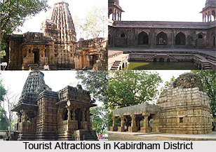
Both these tehsils, Kabirdham and Pandariya have immense historical significance. Kabirdham served as the capital Nagvanshi kings between the period of 9th to 14th century. It was later captured by Haihayvanshi kings who were associated with state Ratanpur. Archaeological ruins of a temple and a fort were built by these kings are still found in this region.

This article is a stub. You can enrich by adding more information to it. Send your Write Up to [email protected]


Share this Article:

Related Articles

More Articles in States of India


East Indian States
East Indian States comprises of Bihar, Jharkhand, West Bengal, Odisha and also the Union Territory of Andaman and Nicobar Islands. It defines the cultural heritage, rich historical background and the linguistic unity.
Erode District
Erode District is one of the districts in the state of Tamil Nadu. The district of Erode is having a land-locked area with no sea coast.
Purnia District in Bihar
Purnia District is located in Bihar and extends from River Ganga to Nepal. The district has a rich Hindu history and glorious past.
South Delhi District
South Delhi District is the third largest district of Delhi as far as its area is concerned. South Delhi District is known for its economic, historical, cultural and social significance.
North Indian States
North Indian States formed the cultural and religious unity in spite of having many foreign invasion and the political disturbances from the early era till the British gained supremacy in Indian sub continent.
Kendujhar District
Kendujhar District, spread over an area of 8,240 sq kms, is as varied as the whole of Orissa with waterfalls roaring gorges, mountains and minerals. The manifold expressions of nature in Kendujhar District are considered as unique.
Hooghly district
Hooghly District along the bank of the river Hooghly is one of the principal trading ports of West Bengal.
Districts of South Tamil Nadu
Districts of South Tamil Nadu consist of many tourism destinations like archaeological sites and the history of Pandyas and Cholas. Considering their proximity to the sea, many districts also boast of serene beaches and coastal beauty.
Flora of Arunachal Pradesh
Flora of Arunachal Pradesh includes infinite species and is a subject of great interests for the botanists.
Districts of South Gujarat
Districts of South Gujarat are the epicenter of Jain pilgrimages and the early Hindu kingdoms.
North West States of India
North West States of India consist of three states, which are Rajasthan, Punjab and Haryana. All of them are culturally and traditionally diverse and they have been ruled by different dynasties in historical time.
Geography Of Chittoor District
Geography of Chittoor district is spread along the topography of the land which is divided into two natural divisions; Chittoor has a dry and healthy climate.
Districts of North Rajasthan
District of Northern part of Rajasthan is dotted with ancient forts and medieval villages.
Districts of North Odisha
District of North Odisha has Bengal boundary and shares the same culture. These are reachable if one pays a weekend visit to Digha.
Districts of West Bihar
Districts of West Bihar is comprised of medieval monuments that were built by the different governors of Mughal era.
Districts of South Haryana
Districts of South Haryana consists of many cities of industrial excellence. These districts are dotted with popular tourism destinations.
Medieval History of Assam
Medieval history of Assam narrates the advent and rule of a number of kingdoms in the region. The prominent dynasties of the kingdom left an everlasting imprint on the socio cultural heritage of India.
Geography of Meghalaya
The suitable climate, highland plateaus, rivers and the flora and fauna together forms the geography of Meghalaya.
Districts of Rayalaseema
Districts of Rayalaseema in Andhra Pradesh state has urban population and rural settlements as well.
Districts of South Punjab
Districts of Southern part of Punjab depict medieval history of Punjab and the rise of Sikhs.