Introduction
 Tirunelveli is the head quarter of the Tirunelveli district of Tamil Nadu. Tirunelveli was considered as one of the oldest city in Indian continent around 3,000 years old.
Location of Tirunelveli
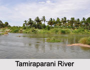
Tirunelveli is located at about 700 km southwest of Chennai. It is around 58 km away from Thoothukudi. This city of historical significance is positioned on the western part of the Thamirabarani River.
History of Tirunelveli
The Puranic version goes that one Vedasrama, a staunch devotee of Lord Shiva, on his pilgrimage from the northern part of universe to the southern part, was invited by Mahadeva in his dream to his abode in the banks of the sacred river Tamiraparani. The delighted devotee came to Sindupoondhurai on the banks of the river and stayed with his family. Once there was a famine, which forced Vedasarma to collect paddy by the way of begging. One day Vedasarma, spread out the paddy to dry under the Sun before the Lord Shiva. While bathing, he prayed to God for the rain, which he thought, could be the only remedy from the famine to save the mankind. His prayer was answered and it rained heavily during his bath. Vedasarma rushed to that place where he had spread his paddy and witnessed a miracle. Despite rain around the area, the paddy, he had spread did not soak with a single drop of water. According to Purana the place is called as "Tiru-nel-veli" which means "Scared Hedged Paddy".
Geography of Tirunelveli
Tirunelveli is bounded by the state of Kerala, Gulf of Mannar and Virudhunagar District, Thoothukudi District and Kanyakumari District. This city is located with a latitudinal limit of l8.73 degree North to 77.7 degree East. The average elevation of this city is 47 meters from the sea level. Tamiraparani River is the main river in Tirunelveli, along with the other rivers like Pachaiyar River, Manimathur River and Chittar river.
Climate of Tirunelveli
The maximum temperature of Tirunelveli is 45 degree Celsius and minimum temperature is 22 degree Celsius. The average annual rainfall is 680mm.
Demography of Tirunelveli
Tirunelveli had a population of 473,637. The sex-ratio of this modern city is about 1,027 females for every 1,000 males, with a national average of 929. The 46,624 people in Tirunelveli were under the age of six, out of which the 23,894 males and 22,730 females. 13.17 percent and 0.32 percent of the population are belonging from Indian Scheduled Tribes. The average literacy rate in Tirunelveli was 81.49 percent.
Economy of Tirunelveli
 Tirunelveli has quite numbers of industries like cement factories, cotton textile mills, spinning and weaving mills, beedi companies and steel products. A large number of small scale industries are supported by NELSIA (Nellai Small Scale Industries Association).
Tourism in Tirunelveli
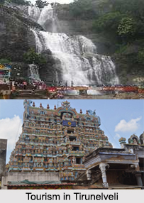 Tourism in Tirunelveli boasts some impeccable Hindu temples, wildlife sanctuaries and waterfalls as attractions and pilgrimage destinations. Tirunelveli City is situated on the banks of the River Thamirabarani in Tamil Nadu. There are several picturesque visiting places in and around Tirunelveli City, which attract lots of tourists. Some of them are given here:
Krishnapuram Temple: The Krishnapuram temple is situated about 13 kms from Tirunelveli city of Tamil Nadu. It is dedicated to Lord Vishnu, which is an important tourist destination. This temple is an important part of art and architecture of Tamil Nadu.
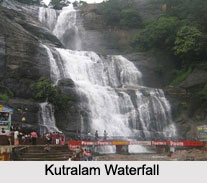
Courtallam Waterfalls: The Courtallam waterfall is situated 59 kms from Tirunelveli. It is called the "Spa of the South" and it is located at an elevation of 170 metres, on the Western Ghats. This is also a health resort apart from being a tourist spot of Tamil Nadu.
Sankaran Koil Temple: It is situated 56 kms north of Tirunelveli. This temple is a representation of fusion of two faiths; Shaivism and Vaishnavism as it contains an image combining both the aspects. All the symbols of Shiva, deer, cobra, moon, etc can be seen bearing on the right half and the left half has all the symbols of Vishnu like Chakra, conch etc. The `Prakarams` of the temple are adorned with many excellent paintings.
 Tenkasi: Tenkasi means "Dakshina Kashi", the Varanasi of the south. This temple is dedicated to Viswanatha. The Pandya king Paranthaga Pandiyan after returning from the Benaras constructed this temple. It is situated 53 kms from Tirunelveli and 7 kms from Courtallam.
Thirumalaiappan Pozhil: This is a beautiful temple dedicated to Lord Muruga atop of a hill rock. It is 15 kms from Courtallam.
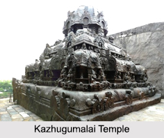
Kazhugumalai Temple: Kazhugumalai temple is situated 76 kms from Tirunelveli. Here, the shrine is created from a huge rock. The unique feature of this temple is that rather than rising from the foundations, it was chiselled from the top.
Thirumalaipuram: This place is situated 16 kms from Tenkasi. A rock-cut temple here with Ganesha, Vishnu and dancing Shiva can be seen here.
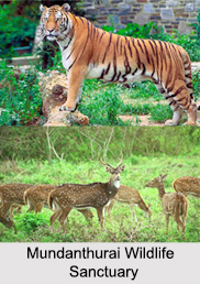
Kalakadu Wildlife Sanctuary: It is situated 47 kms from Tirunelveli. The flora and fauna of this sanctuary are very famous. Tiger, panther, jackal, wild dogs, cobra, python and several snakes and other reptiles, the lion-tailed monkey, etc can be seen.
Shengaltheri: It is situated in the Kalakadu mountain area. It is 68 kms from Tirunelveli. It is in the area of Kalakadu wildlife sanctuary. It is renowned for its natural scenery and healthy climate, which makes it a perfect picnic spot. A perennial waterfall also can be seen here.
Visiting Information
Tirunelveli is connected with the roadways, railways and airways. The nearest airport is Vagaikulam airport, which is 24 kilometer away from Tirunelveli. The Madurai Airport and the Thiruvananthapuram Airport is also easy to access. Tirunelveli Junction Railway Station is connected to major cities. Tirunelveli is well connected to the roads. The city is located on National Highways 7. It is also accessible by road from Madurai, Nagercoil and connected to the other highways to Kollam, Tiruchendur, Rajapalayam and Sankarankovil.


