 Supaul District is one of the thirty-eight districts of Bihar state. Supaul District was carved out from Saharsa District on 14 March 1991. Earlier Supaul was a subdivision. Supaul town is the administrative headquarters of this district. This district occupies an area of 2,410 km2. Supaul district is a part of the Kosi River division.
History of Supaul District
The District of Supaul had been a part of Mithilanchal since the Vedic period. The area has been referred to as the fishery area (Matsya Kshetra) in the Hindu mythology. The two oldest democracies namely Angutaran and Apadnigam are known for their existence in the Buddhist era.
Geography of Supaul District
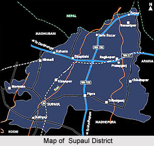
Supaul district occupies an area of 2,425 square kilometres. Supaul district is bordered by Nepal to the north, Araria district to the east, Madhepura district and Saharsa districts to the south and Madhubani district to the west. The Kosi River flows through this district, which is regularly affected by the flood caused by this river.
The district comprises of 4 sub-divisions: Supaul, Birpur, Triveniganj and Nirmali. Supaul sub-division consists 4 blocks: Supaul, Kishanpur, Saraigadh-Bhaptiyahi and Pipra. Birpur sub-division is further divided into 3 blocks: Basantpur, Raghopur and Pratapganj. Triveniganj sub-division has 2 blocks: Triveniganj and Chhatapur. Nirmali sub-division comprises 2 blocks: Nirmali and Maruna. Agriculture is the major occupation of this district and paddy is the main crop.
Demography of Supaul District
According to the 2011 census Supaul district has a population of 2,228,397. This gives it a ranking of 204th in India. The district has a population density of 919 inhabitants per square kilometer. Its population growth rate over the decade 2001-2011 was 28.62 %. Supaul has a sex ratio of 925 females for every 1000 males and a literacy rate of 59.65 %.
This article is a stub. You can enrich by adding more information to it. Send your Write Up to content@indianetzone.com


