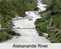
 The source of the Alakananda River is at the confluence of Satopanth Glacier and Bhagirathi Kharak Glacier at an elevation of 3,880 metres and meets the Saraswati river tributary at Mana, India, 21 km from Tibet. Satopanth is a triangular lake, which is located at a height of 4402 meters above the sea level and named after the Hindu trinity Lord Brahma, Vishnu and Shiva. The Alakananda River is considered to be one of the major rivers of Northern India.
Origin of the Alakananda River
Alakananda is one of the two headstreams of the Ganga with its source confluence being at the Bhagirathi River. It is one of the left bank tributaries of the Ganges at Devaprayag. The river is first formed at the confluence of Dhauliganga and Vishnuprayag at the base of the Joshimath mountain in the Chamoli district of Uttarakhand. Tapovan, known for its hot sulphur springs is situated at the banks of the Dhauliganga river.
Tributaries of the Alakananda River
Several rivers flowing in the Garhwal division merges with the Alakananda River at Panch Prayag, which is also referred to as the "holy confluence of rivers". Alakananda meets Dhauliganga river at Vishnuprayag, Nandikini River at Nandaprayag, Pindar River at Karnaprayag , Mandakini River at Rudraprayag, finally it meets the Bhagirathi River at Devaprayag, where it officially becomes the Ganga River. The left bank tributaries are Saraswati, Dhauliganga, Nandakini, Pindar and its right bank tributary is Mandakini.
Along the banks of the Alaknanda River within the two mountain ranges of Nar and Narayan with the Neelkanth peak on the background are the famous pilgrimage Badrinath Temple and the natural spring Tapt Kund. This picturesque panorama is a breathtaking sight and is itself an enchantment for tourists and is also known as the `Garhwal queen`. Many multi-day adventure trips including rafting and kayaking can be enjoyed here.


