Introduction
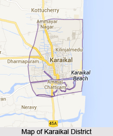 Karaikal District is one of the four administrative districts of Puducherry. Karaikal town about 16 km north of Nagappattinam and 9 km south of Tarangambadi is the regional headquarters. Karaikal region is embedded in the Nagappattinam District and Thiruvarur District of Tamil Nadu. Karaikal District lies between 10 degree 49 minutes and 11 degree 1 minute northern latitude and between 79 degree 43 minutes and 79 degree 52 minutes eastern longitude about 150 kms. Total area covered by Karaikal District is 161 sq km and has a population of 1,70,640 as per 2001 census. Karaikal region is made up of the Communes of Karaikal, Kottuchcheri, Nedungadu, Tirunallar, Niravi and Tirumalarajanpattinam.
History of Karaikal District
 Several explanations are offered for the name Karaikal. There is no doubt that it is a combination of two words, `karai` and `kal`. Both `karai` and `kal` have numerous meanings, of which the more plausible one being `a canan made of lime mixture`. According to Julien Vinson, the town is said to have been known as Karagiri in Sanskrit language. Karaikal area formed an integral part of the Pallava Dynasty in the 8th century (CE 731-796).
Geography of Karaikal District
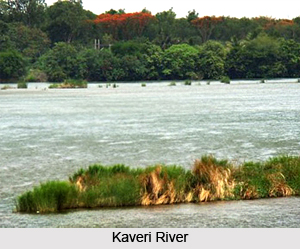
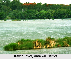 Geography of Karaikal District is forming part of the fertile Kaveri delta and the region is completely covered by the tributaries of Kaveri River. Covered completely by a thick mantle of alluvium of variable thickness, the region is basically flat having a gentle slope towards the Bay of Bengal in the east. It is limited on the north by the Nandalar and on the south-east by the Vettar. The group of rocks known as Cuddalore formations is met with in the area adjacent to Karaikal region in Nagappattinam District.
Karaikal, situated on the east coast of India, near latitude 11 degree north in the deltaic region of the Kaveri, experiences tropical maritime type of climate with small daily range of temperature and moderate rainfall. Karaikal has an annual average rainfall of about 126 cm, 68 percent of which occurs during October to December. The amount of rainfall during the south-west monsoon period is small, being less than 20 per cent of the annual rainfall. November is the rainiest month, accounting for about a third of the annual total. The range of variation of annual rainfall is wide. Variability of annual rain fall is fairly large, so that significant variations in rain fall from year to year may be expected. Drought conditions with the annual rainfall of less than 75 percent of the normal may be expected once in three years on an average. In a year there are on an average about 55 rainy days.
The level of temperatures in Karaikal is about the same as in Puducherry. December and January are the coolest months with the maximum at about 28 degree Celsius and the minimum at about 23 degree Celsius. The level of humidity and the pattern of cloudiness and surface winds are the same as in Pond cherry. Although slight variations in the month wise occurrence of depressions and storms are noticeable, thunder-storms generally occur during April to November, particularly in April, September and October.
Geography of Karaikal District includes several river system and water resources. The main branches of Kaveri below Grand Anicut are the Kodamurutti, Arasalar, Virasolanar and the Vikramanar. Although Arasalar and its branches spread through Karaikal, the waters of Kodamurutti and Virasolanar also meet the irrigation needs of the region. Arasalar having a total run of 24 kms enters Karaikal region, a little east of Akalanganni. It forms the natural boundary line separating Niravi Commune from Tirunallar on the north-west and Karaikal on the north-east.
 The Nattar, branching off from Arasalar at Sakkottai in Thanjavur District, runs a distance of 11.2 km in a south-easterly direction across Nedungadu and Kottuchcheri. The Vanjiar fed by Arasalar, takes its course along the northern boundary of Tirunallar commune, drops on a south-easterly curve towards Karaikal commune and merges with the Arasalar, south-east of Karaikal town after covering a distance of about 9 km.
The Nular, also fed by the Arasalar, runs a distance of 13.77 km before it joins Vanjiar north-east of Karaikal town. The Puravadaiyanar and the Tirumalarajanar are the branches of Kodamurutti. The flow of Tirumalarajanar which forms the natural boundary line between Niravi and Tirumalarajanpattinam communes runs a distance of 5.13 km. before it enters the sea, north of Pattanachcheri. The Nandalar takes off from Virasolan and meanders across the northern boundary of the region.
Karaikal region gets most of its water for irrigation from Kaveri and as such ground water resources in the region have not been fully developed. Here the water table lies at depths of around 3 and 4 metres below ground level and during summer declines to 6 to 7 metres below ground level. In a number of villages of Karaikal District filter point wells piercing sandy materials down to about five metres and fitted with hand-pumps supply fairly good quality water. In many cases the quality of shallow ground water is rather poor. In the past, several attempts were made to tap ground water by means of deep tube wells for drinking and agricultural purposes.
The region is occupied by alluvium consisting of sands and clays. Data of bore-holes put down in the vicinity of Karaikal indicate that the thickness of the alluvium is possibly of the order of 68 meters. The alluvium is underlain by the Karaikal beds of Pliocene age consisting of sands, gravels and clay. Further, ground water in Karaikal is developed chiefly by means of dug wells or filter-point wells piercing blown sands and alluvium. A few bore-holes not exceeding 50 metres in depth drilled in the vicinity of Karaikal were reported to have been abandoned on account of the poor quality of water in the granular zones in the alluvium.
To the south and west of Muppattankudi and towards Mathur further west, sands are met with down to depths of 8 to 12 metres below surface. About 1.6 km south-east of Nedungadu, in the western portion of the region, confined aquifers have been tapped by a tube-well. Karaikal town gets its water by means of a battery of a shallow interconnected open wells and an infiltration gallery in the bed of Arasalar. A few villages between Akalanganni and Karaikal also get their water supply from this source.
Karaikal District is an important stratigraphic horizon which indicated the prospects of `oil shows`. The Karaikal area is completely covered by a thick mantle of alluvium. Several important mineral resources such as Brick clays and Kanker are found in the district. Karaikal District is also rich in flora and fauna.
Economy of Karaikal District
Economy of Karaikal District is dependent on agriculture. Situated in the Kaveri delta, the irrigation facilities of this district permit the cultivation of rice over large areas. Sugarcane is also cultivated here but only as a subsidiary crop. The cultivation of millets is very little or practically nil. Karaikal region lies in the fag end of Kaveri Delta. Main source of irrigation is river water by canal system. Other sources are deep bore wells and filter points. In addition to paddy crop, pulses, cotton, groundnut, banana and vegetables are also encouraged. Karaikal region has 10 fishing hamlets.
Culture of Karaikal District
 This district has a very interesting language composition. This is primarily due to the scattered location of the regions. People of different religions reside in Karaikal district. Although it is not known how long and to what extent this fourfold classification was adhered to in practice in the areas that now fall under this territory, it may be assumed that the four fold division of society in accordance with the Hindu Shastra continued to be respected even during the Chola days. Many new castes found a place in the social strata of Karaikal region. Interestingly, the French having come here originally as traders did not interfere in matters of customs and practices.
Even after they established themselves as the rulers of the land they allowed the natives to maintain good relations with them.
This district has a very interesting language composition. This is primarily due to the scattered location of the regions. People of different religions reside in Karaikal district. Although it is not known how long and to what extent this fourfold classification was adhered to in practice in the areas that now fall under this territory, it may be assumed that the four fold division of society in accordance with the Hindu Shastra continued to be respected even during the Chola days. Many new castes found a place in the social strata of Karaikal region. Interestingly, the French having come here originally as traders did not interfere in matters of customs and practices.
Even after they established themselves as the rulers of the land they allowed the natives to maintain good relations with them.
People of Karaikal District
 People of Karaikal District are the regional inhabitants of country, which is present in the Indian Union Territory of Puducherry. They have been adhering to their individual customs and traditions since times ancient times. People of this Indian district belong to different religions and communicate with the aide of Tamil language, which is the most commonly used language in this area.
Demography of Karaikal District : As per the records of 2011 census, Karaikal District possesses a population of 2, 00, 314 and has been ranked 589th in the entire country. The literacy rate of this district measure 87.83% and this region boasts of a sex ratio of 1084 females for every 1000 males.
Culture of Karaikal District : Since, Karaikal District is bounded by the southern Indian state of Tamil Nadu, Tamil forms the principal language which is employed by the local residents of this district, for the purpose of conversing. The four orders of the caste system namely, `Brahmins`, `Kshatriyas`, `,Vaishyas` and `Shudras` have been observed in Karaikal District since ancient ages, as per the Hindu customs and beliefs. Historians are of the view that this particular caste structure used to be followed also during the regime of the Chola Dynasty.
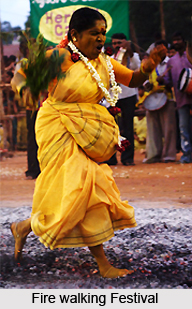
With the passage of time and the arrival of Kanarese and Telugu people into Karaikal District, several new castes were introduced in this portion of India, especially during the existence of Vijayanagar Empire. When this region was ruled by the French, they had not intervened with such caste system in this district. It is said that when the French had re-established their rule in Karaikal District during 1816, the Hindus were governed under the provisions of the French Civil Code. However, no modifications were made to the traditional social strata of Karaikal. The local people celebrate numerous festivals which include `Masimagam Festival`, `Sani Peyarchi festival`, `Kandoori festival`, and `Fire Walking festival.`
Religion of Karaikal District : Hindus, Christians and Muslims constitute the major religions in the district of Karaikal. There are about 99 temples in Karaikal, out of which 8 are supervised by private management and the remaining 91 are controlled by the Government. Devotees will find that there exist 8 Ganesha temples, 15 Vaishnavite temples, 30 Shaivite shrines and 13 other shrines which are dedicated to other religious deities.
Muslims are a predominant community residing in Karaikal District, and have been dwelling here even prior to the advent of the French in the year 1674. Arabs had shifted to this part of the nation in the earlier portion of the 7th century. This district contains two mosques, and a majority of the Muslims belonging to Karaikal District are Sunni Muslims.
Tourism in Karaikal District
 Tourism in Karaikal District includes visits to several religious sites. There are several holy temples dedicated to Lord Shiva and Vaishnava temples in Karaikal region, which are worth visiting. The places of interest in Karaikal region attract a large number of tourists every year. The Karaikal sandy beach is one of the best natural beaches in south India. The beaches of this region are easily accessible. In addition to natural sandy beach, a boat jetty in the Arasalar, children`s park, immovable sitting chairs along the roads, restaurant, and tennis court are other attractions for the tourists.
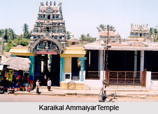
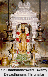
There is a small beautiful temple in the heart of the town for Karaikal Ammaiyar. `Mangani` festival is celebrated every year during the month of June or July. Mangani festival is said to be celebrated for many centuries in the Karaikal Ammaiyar temple. It is another major tourist attraction offered by Karaikal District. The traditional temple of `Lord Saneeswara` (Saturn) at Thirunallar which is just 5 kms away from Karaikal town is worth visiting. This is the only temple in the town dedicated to Lord Saturn and is well known throughout the country. Oduthurai is the annual festival celebrated in Sri Kaliamman temple and it offers a glimpse of the rich traditions of the region. Sri Uppilamaniar Temple, Sri Kailasanathar Temple, Nitya Kalyanaperumal Temple, Karaikal Ammaiyar Temple, Sri Parvatheeswaraswami Temple and Sri Kothandaramaswami temple are also very famous.
Tourism in Karaikal District also offers visits to the places mentioned below -
Ambagarattur: Second largest village of the district famous for Bhadrakaliamman temple. Twelve days annual festival celebrated during May-June attracts many thousands of devotees.
Dharmapuram: This place is popular for Sri Yazhmurinatheeswarar temple.
Karaikovilpattu: This village is referred to as Thiruthelicherry in some religious texts. Thus, it is assumed that this village must have been the abode of an important temple. This is one of the four places in Karaikal region visited by Saint Thirugnanasambandar. Surasmaharam, Vijayadasmi, Kadaimuzhukku and Thiruvadhirai festivals are celebrated here.
Karukkalacherry: 3 kms from Karaikal the main pilgrimage centres of this village are Sri Karu Mariamman temple and Sri Vellai Vinayagamurthi temple.
Kottucherry: Sri Kodeeswaramudayar temple is the principal place of worship here.
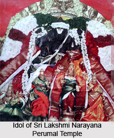
Kurumbagaram: Sri Lakshmi Narayana Perumal temple is the principal centre of worship here. This village lies at a distance of around 11 kms from Karaikal.
Niravi: This village is noted for its temple of Sri Jambunathaswamy claimed to be about 300 years old. The thiruvathirai and thirukkarthigai festivals are celebrated in this temple which is attended by several hundred people.
Jadayupureeswarar Temple is said to be the oldest. Masimagam is the most important. Scenes from Ramayana are re-enacted with the help of wooden images during masi (February-March) festival. These are some of the popular attractions of Karaikal District.


