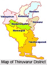
 Thiruvarur district was carved out as a different district by detaching Valangaiman taluk from Thanjavur district and Thiruvarur, Nannilam, Kudavasal, Needamangalam, Mannargudi, Thirutturaippundi taluks from the district of Nagappatinam on the 1st of January 1997. There are two revenue divisions, seven taluks, ten community development blocks, three municipalities and seven Town Panchayats in Thiruvarur District. The first district collector of the Thiruvarur district was Thiru M. R. Mohan (IAS).
History of Thiruvarur District
Thanjavur attained prominence under the Chola rulers who were paramount in South India during the 9th to the 12th centuries. They were excellent rulers and mighty builders. Many examples are found in the district which bears testimony to this. Many of these temples reflect the genius and architectural proficiency in sculpture, painting and wood-carving. The administration of Thanjavur was given over to English fully under the Treaty of 1799. The ruler of Thanjavur was allowed to retain the fort of Thanjavur with very limited powers. When the ruler died in the year 1841 without any heir, the Thanjavur fort was also annexed by the British East India Company. Thanjavur remained under the British rule until 1947 when India attained freedom. Then, on the 1st of January 1997, the new district of Thiruvarur was formed.
Geography of Thiruvarur District
The total area covered by the district of Thiruvarur is 2097.09 square kilometers. It is located between ten degree twenty minutes and eleven degree seven minutes to the North Latitude and between seventy nine degree fifteen minutes and seventy nine degree forty five minutes to the East longitude. The district is situated ten meters above the mean sea level. The maximum temperature experienced by this district is 36.9 degree Celsius and the minimum temperature is 29.8 degree Celsius. The total area under cultivation in this district is 237715 hectares and the major crops grown here include rice, sugarcane, pulses, cotton, groundnut, etc.
Administration of Thiruvarur District
The administration of the Thiruvarur district in the Tamil Nadu state is having the collector as the head and the Collector is assisted by a number of officers in his general work of administration. There are two revenue divisions in this district, seven taluks, twenty seven firkas and five hundred and seventy three villages. Apart from these, there are ten community development blocks, four municipalities, seven town panchayats, four hundred and thirty panchayat villages, eighteen district panchayat wards, one hundred and seventy six panchayat union wards and three thousand one hundred and eight village panchayat wards.
Education in Thiruvarur District
 The Educational system in the district of Thiruvarur is well-developed and there are several educational institutions in this district. There are about six hundred and ninety six primary schools, one hundred and ninety middle schools, seventy high schools, fifty six higher secondary schools, two engineering colleges, seven arts and science colleges, three technical institutions, one music school and two teacher`s training colleges.
Tourism in Thiruvarur District
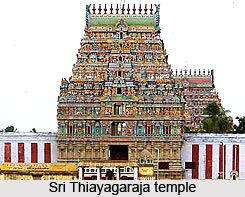
Tourism in the district of Thiruvarur is having several options including some of the famous centres of pilgrimage and natural beauties. Some of the temples in this district are Sri Thiayagaraja temple, Sri Rajagopalaswamy temple, Sri Murugan temple, Sri Kothandaramar temple, Sri Saraswathi temple, Sivan temple at Alangudi, etc. Apart from these there are various other places of interest which are like Jambavanodai Dargha, Muthupettai (Jambavanodai) Lagoon, Bird Sanctuary at Vaduvoor, Bird Sanctuary at Udayamarthandapuram, etc.
The district of Thiruvarur possesses natural resources like crude oil and natural gas. The total reserved forest area of this district is 2542 hectares which includes timber, fuel wood, bamboo, pulp wood, etc. This district of the Tamil Nadu state is one of the best centres of pilgrimage in the state where pilgrims as well as general tourists visit throughout the year.